Trail Walking Sissach - Huenersädel - Rickenbacher Fluh - Sissacher Fluh - Photo

Huenersädel - Rickenbacher Fluh - Sissacher Fluh

 muelltho
muelltho

User

© OpenStreetMap contributors
Length
Length
4.6 km
Max alt
Max alt
753 m
Uphill gradient
Uphill gradient
200 m
Km-Effort
Km-Effort  
7.3 km
Min alt
Min alt
602 m
Downhill gradient
Downhill gradient
208 m
Boucle
Boucle
Yes
Creation date :
2014-12-11 00:00:00.0
Updated on :
2014-12-11 00:00:00.0

(0 Reviews)

Walking
Walking
1h40
Difficulty : Unknown

Scan this QR Code to open this trail in the SityTrail application

FREE GPS app for hiking

Logo SityTrail SityTrail

IGN / Geographical institutes

Download SityTrail from the App Store Download SityTrail from Google Play

Logo SityTrail SityTrail World

The world is yours!

Download SityTrail from the App Store Download SityTrail from Google Play Download SityTrail on Huawei AppGallery

About

Trail Walking of 4.6 km to be discovered at Basel-Landschaft, Bezirk Sissach, Sissach. This trail is proposed by muelltho.

Description

Verpflegung auf der Sissacherfluh

Elevation profile

Positioning

Country:
Switzerland
Region :
Basel-Landschaft
Department/Province :
Bezirk Sissach
Municipality :
Sissach
Location:
Unknown
Start:(UTM)
410673 ; 5259698 (32T) N.

Trails nearby

Trail On foot Gelterkinden - Gelterkinden - Rünenberg - Photo
On foot
GUIDE+

On foot

Easy
Gelterkinden, Basel-Landschaft, Bezirk Sissach, Switzerland
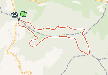
5.4 km | 8.2 km-effort
1h 51min
No
Trail On foot Gelterkinden - Gelterkinden - Wenslingen - Photo
On foot
GUIDE+

On foot

Easy
Gelterkinden, Basel-Landschaft, Bezirk Sissach, Switzerland
5.8 km | 8.5 km-effort
1h 55min
No
Trail On foot Gelterkinden - Gelterkinden - Tecknau - Photo
On foot
GUIDE+

On foot

Easy
Gelterkinden, Basel-Landschaft, Bezirk Sissach, Switzerland
3.6 km | 4.4 km-effort
59min
No
Trail On foot Liestal - Augst-Rankhof-Büchlihau- Chapf - Photo
On foot
GUIDE+

On foot

Easy
Liestal, Basel-Landschaft, Bezirk Liestal, Switzerland
6 km | 7.6 km-effort
1h 44min
No
Trail On foot Hersberg - Kaiseraugst-Hersberg - Photo
On foot
GUIDE+

On foot

Easy
Hersberg, Basel-Landschaft, Bezirk Liestal, Switzerland
10.8 km | 13.6 km-effort
3h 4min
No
Trail On foot Ormalingen - Junkerschloss - Ormalingen - Photo
On foot
GUIDE+

On foot

Easy
Ormalingen, Basel-Landschaft, Bezirk Sissach, Switzerland
3.9 km | 6.1 km-effort
1h 22min
No
Trail On foot Arisdorf - Giebenach-Hersberg - Photo
On foot
GUIDE+

On foot

Easy
Arisdorf, Basel-Landschaft, Bezirk Liestal, Switzerland
3.6 km | 5.5 km-effort
1h 15min
No
Trail On foot Tenniken - Känerkinden - Gisiberg - Photo
On foot
GUIDE+

On foot

Easy
Tenniken, Basel-Landschaft, Bezirk Sissach, Switzerland
3.7 km | 4.8 km-effort
1h 5min
No
Trail On foot Wintersingen - Rebenweg - Photo
On foot
GUIDE+

On foot

Easy
Wintersingen, Basel-Landschaft, Bezirk Sissach, Switzerland
3.3 km | 4.4 km-effort
1h 0min
No


Close
My subscriptions