Trail Other activity Gündlischwand - Schynige Platte - Faulhorn - Grosse Scheidegg Tag 1 - Photo

Schynige Platte - Faulhorn - Grosse Scheidegg Tag 1

 muelltho
muelltho

User

© OpenStreetMap contributors
Length
Length
10.8 km
Max alt
Max alt
2655 m
Uphill gradient
Uphill gradient
934 m
Km-Effort
Km-Effort  
21 km
Min alt
Min alt
1919 m
Downhill gradient
Downhill gradient
258 m
Boucle
Boucle
No
Creation date :
2014-12-11 00:00:00.0
Updated on :
2014-12-11 00:00:00.0

(0 Reviews)

Other activity
Other activity
--
Difficulty : Unknown

Scan this QR Code to open this trail in the SityTrail application

FREE GPS app for hiking

Logo SityTrail SityTrail

IGN / Geographical institutes

Download SityTrail from the App Store Download SityTrail from Google Play

Logo SityTrail SityTrail World

The world is yours!

Download SityTrail from the App Store Download SityTrail from Google Play Download SityTrail on Huawei AppGallery

About

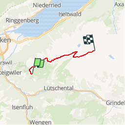
Trail Other activity of 10.8 km to be discovered at Bern, Interlaken-Oberhasli administrative district, Gündlischwand. This trail is proposed by muelltho.

Description

1. Tag Schynige Platte - Faulhorn
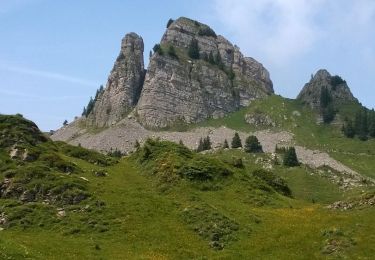
Von der Bergstation der Schynige Platte Bahn steigt der Weg gemächlich an,führt am Lauchernhorn vorbei ins Sägistal und weiter zur Männdlenen Hütte.
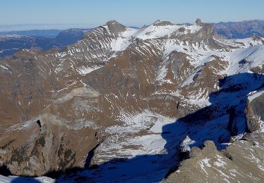
Auf der ersten Teilstrecke trifft man auf verschiedene Stein- und Fels-formationen und zwischendurch blickt man auf das Seebecken vom Brienzersee hinunter.
Bei der Männdlenen Hütte steigt der Weg etwas steiler an bis auf den Grat der Winteregg, von wo man einen wunderbaren Blick auf das Dreigestirn Eiger, Mönch und Jungfrau hat.
Die Wanderung führt nun relativ flach weiter und steigt auf den letzten Metern zum Faulhorn nochmals kurz an.

Elevation profile

Positioning

Country:
Switzerland
Region :
Bern
Department/Province :
Interlaken-Oberhasli administrative district
Municipality :
Gündlischwand
Location:
Unknown
Start:(UTM)
416684 ; 5167072 (32T) N.

Trails nearby

Trail On foot Lauterbrunnen - CH-Isenfluh - Alpweg - Photo
On foot
GUIDE+

On foot

Easy
Lauterbrunnen, Bern, Interlaken-Oberhasli administrative district, Switzerland
4.5 km | 7.5 km-effort
1h 42min
No
Trail On foot Lauterbrunnen - Sousegg - Sattel - Photo
On foot
GUIDE+

On foot

Easy
Lauterbrunnen, Bern, Interlaken-Oberhasli administrative district, Switzerland
4.2 km | 10.9 km-effort
2h 29min
No
Trail Walking Gündlischwand - Schynige Platte chemin panoramique 06.07.15 - Photo
Walking
duamerg

Walking

Medium
Gündlischwand, Bern, Interlaken-Oberhasli administrative district, Switzerland
7.4 km | 11.7 km-effort
3h 0min
Yes
Trail Other activity Grindelwald - y10_kleine_scheidegg - Photo
Other activity
GUIDE+

Other activity

Very easy
Grindelwald, Bern, Interlaken-Oberhasli administrative district, Switzerland
11.5 km | 15.6 km-effort
3h 21min
No
Trail Cycle Interlaken - st_ral_3 - Photo
Cycle
GUIDE+

Cycle

Very easy
Interlaken, Bern, Interlaken-Oberhasli administrative district, Switzerland
59 km | 69 km-effort
Unknown
No
Trail Walking Gündlischwand - Eiger, Mönch und Jungfrau im Blickfeld - Photo
Walking
GUIDE+

Walking

Very easy
Gündlischwand, Bern, Interlaken-Oberhasli administrative district, Switzerland
15.9 km | 27 km-effort
Unknown
No
Trail Cycle Interlaken - st_ral_09_05 - Photo
Cycle
GUIDE+

Cycle

Very easy
Interlaken, Bern, Interlaken-Oberhasli administrative district, Switzerland
23 km | 52 km-effort
7h 28min
No
Trail Walking Interlaken - st_mt_4 - Photo
Walking
GUIDE+

Walking

Very easy
Interlaken, Bern, Interlaken-Oberhasli administrative district, Switzerland
128 km | 182 km-effort
Unknown
No
Trail Walking Gündlischwand - Schynige Platte    First - Photo
Walking
domi68440

Walking

Difficult
Gündlischwand, Bern, Interlaken-Oberhasli administrative district, Switzerland
16.4 km | 27 km-effort
6h 59min
No


Close
My subscriptions