![](/images/other/stat-length.png)
![Trail Walking Charmes - Charmes-Sion - Photo](https://media.geolcdn.com/t/1900/400/ext.pjpeg?maxdim=2&url=https%3A%2F%2Fstatic1.geolcdn.com%2Fsiteimages%2Fupload%2Ffiles%2F1553511878bg_sport_marche.png)
Charmes-Sion
claudemoret
User
![Length](/images/other/stat-length.png)
Length
27 km
![Max alt](https://static1.geolcdn.com/siteimages/upload/files/1508320355ic_sort_altitude_max_24dp.png)
Max alt
499 m
![Uphill gradient](https://static1.geolcdn.com/siteimages/upload/files/1508320355ic_sort_den_pos_24dp.png)
Uphill gradient
612 m
![Km-Effort](/images/other/stat-length.png)
Km-Effort
34 km
![Min alt](https://static1.geolcdn.com/siteimages/upload/files/1508320355ic_sort_altitude_min_24dp.png)
Min alt
242 m
![Downhill gradient](https://static1.geolcdn.com/siteimages/upload/files/1508320355ic_sort_den_neg_24dp.png)
Downhill gradient
389 m
![Boucle](https://static1.geolcdn.com/siteimages/upload/files/16400158638029165_repeat_loop_refresh_sync_direction_icon.png)
Boucle
No
Creation date :
2014-12-10 00:00:00.0
Updated on :
2019-08-10 16:10:37.82
![Walking](https://static1.geolcdn.com/sitytour/trail-icons/101.png)
4h41
Difficulty : Unknown
![Scan this QR Code to open this trail in the SityTrail application](https://capi.geolives.com/qq0zvz2zws4bq2lad0pu/sitytour/trails/188079/qr.png?size=200)
FREE GPS app for hiking
About
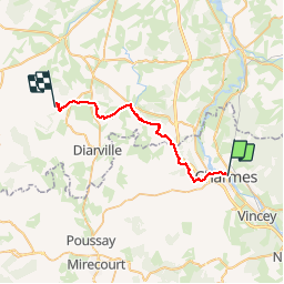
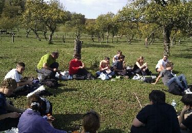
Trail Walking of 27 km to be discovered at Grand Est, Vosges, Charmes. This trail is proposed by claudemoret.
Description
Cette randonnée n'étant pas en boucle nécessite une petite organisation. Perso, j'avais déposé un vélo à Sion et suis revenu à Charmes avec. Belle campagne France profonde avec la grimpette de Sion pour finale.
Positioning
Country:
France
Region :
Grand Est
Department/Province :
Vosges
Municipality :
Charmes
Location:
Unknown
Start:(Dec)
Start:(UTM)
299695 ; 5361351 (32U) N.
Comments
Trails nearby
![Trail Walking Charmes - Charmes - Photo](https://media.geolcdn.com/t/375/260/09938933-c74a-4562-9c7f-a692c50ccf43.jpg&format=jpg&maxdim=2)
![Walking Walking](https://static1.geolcdn.com/sitytour/trail-icons/101.png)
![Trail On foot Gripport - Circuit de Viacelle - Photo](https://media.geolcdn.com/t/375/260/f4362cdc-4ce2-4be1-80fb-708f5c17064d.jpeg&format=jpg&maxdim=2)
![On foot On foot](https://static1.geolcdn.com/sitytour/trail-icons/100.png)
Circuit de Viacelle
On foot
Easy
Gripport,
Grand Est,
Meurthe-et-Moselle,
France
![](/images/other/stat-length.png)
12.6 km | 15.9 km-effort
3h 36min
![](https://static1.geolcdn.com/siteimages/upload/files/16400158638029165_repeat_loop_refresh_sync_direction_icon.png)
Yes
![Trail Walking Charmes - Charmes Île sous Essegney - Photo](https://media.geolcdn.com/t/375/260/8e8d0c8f-c1af-413e-962a-acb8a804c5c8.jpg&format=jpg&maxdim=2)
![Walking Walking](https://static1.geolcdn.com/sitytour/trail-icons/101.png)
Charmes Île sous Essegney
Walking
Charmes,
Grand Est,
Vosges,
France
![](/images/other/stat-length.png)
5.3 km | 5.9 km-effort
1h 45min
![](https://static1.geolcdn.com/siteimages/upload/files/16400158638029165_repeat_loop_refresh_sync_direction_icon.png)
Yes
![Trail Walking Charmes - charmes - Photo](https://media.geolcdn.com/t/375/260/ec135420-ff52-45f8-a92d-19b9f128f4e7.jpg&format=jpg&maxdim=2)
![Walking Walking](https://static1.geolcdn.com/sitytour/trail-icons/101.png)
![Trail Walking Charmes - tranchée loup - Photo](https://media.geolcdn.com/t/375/260/ext.jpg?maxdim=2&url=https%3A%2F%2Fstatic1.geolcdn.com%2Fsiteimages%2Fupload%2Ffiles%2F1553511878bg_sport_marche.png)
![Walking Walking](https://static1.geolcdn.com/sitytour/trail-icons/101.png)
tranchée loup
Walking
Easy
(1)
Charmes,
Grand Est,
Vosges,
France
![](/images/other/stat-length.png)
11 km | 12.4 km-effort
2h 44min
![](https://static1.geolcdn.com/siteimages/upload/files/16400158638029165_repeat_loop_refresh_sync_direction_icon.png)
Yes
![Trail Other activity Charmes - joelette - Photo](https://media.geolcdn.com/t/375/260/ext.jpg?maxdim=2&url=https%3A%2F%2Fservices.sitytrail.com%2FGeolivesWS%2FDownloadMedia.ashx%3FTrailID%3D159139%26Media%3D20121021130847.jpeg)
![Other activity Other activity](https://static1.geolcdn.com/sitytour/trail-icons/900.png)
joelette
Other activity
Very easy
Charmes,
Grand Est,
Vosges,
France
![](/images/other/stat-length.png)
12 km | 15.1 km-effort
3h 8min
![](https://static1.geolcdn.com/siteimages/upload/files/16400158638029165_repeat_loop_refresh_sync_direction_icon.png)
No
![Trail Road bike Charmes - Charmes le 29 07 2023 - Photo](https://media.geolcdn.com/t/375/260/63fde4c8-6cf7-4005-acb4-0f5d2c73424a.jpg&format=jpg&maxdim=2)
![Road bike Road bike](https://static1.geolcdn.com/sitytour/trail-icons/201.png)
Charmes le 29 07 2023
Road bike
Charmes,
Grand Est,
Vosges,
France
![](/images/other/stat-length.png)
25 km | 27 km-effort
1h 48min
![](https://static1.geolcdn.com/siteimages/upload/files/16400158638029165_repeat_loop_refresh_sync_direction_icon.png)
Yes
![Trail On foot Florémont - Variante Bois Banni - Photo](https://media.geolcdn.com/t/375/260/ext.jpg?maxdim=2&url=https%3A%2F%2Fstatic1.geolcdn.com%2Fsiteimages%2Fupload%2Ffiles%2F1545311037marcheuse_200dpi.jpg)
![On foot On foot](https://static1.geolcdn.com/sitytour/trail-icons/100.png)
Variante Bois Banni
On foot
Easy
Florémont,
Grand Est,
Vosges,
France
![](/images/other/stat-length.png)
3.5 km | 4.6 km-effort
1h 2min
![](https://static1.geolcdn.com/siteimages/upload/files/16400158638029165_repeat_loop_refresh_sync_direction_icon.png)
No
![Trail Walking Charmes - charmes - Photo](https://media.geolcdn.com/t/375/260/ext.jpg?maxdim=2&url=https%3A%2F%2Fstatic1.geolcdn.com%2Fsiteimages%2Fupload%2Ffiles%2F1553511878bg_sport_marche.png)
![Walking Walking](https://static1.geolcdn.com/sitytour/trail-icons/101.png)