Trail Walking Chambon-sur-Lac - Chaudefour - Photo
 Orage
Orage

User

© OpenStreetMap contributors
Length
Length
14.9 km
Max alt
Max alt
1844 m
Uphill gradient
Uphill gradient
893 m
Km-Effort
Km-Effort  
27 km
Min alt
Min alt
1142 m
Downhill gradient
Downhill gradient
887 m
Boucle
Boucle
Yes
Creation date :
2014-12-10 00:00:00.0
Updated on :
2014-12-10 00:00:00.0

(1 Reviews)

Walking
Walking
5h26
Difficulty : Unknown

Scan this QR Code to open this trail in the SityTrail application

FREE GPS app for hiking

Logo SityTrail SityTrail

IGN / Geographical institutes

Download SityTrail from the App Store Download SityTrail from Google Play

Logo SityTrail SityTrail World

The world is yours!

Download SityTrail from the App Store Download SityTrail from Google Play Download SityTrail on Huawei AppGallery

About

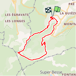
Trail Walking of 14.9 km to be discovered at Auvergne-Rhône-Alpes, Puy-de-Dôme, Chambon-sur-Lac. This trail is proposed by Orage.

Elevation profile

Positioning

Country:
France
Region :
Auvergne-Rhône-Alpes
Department/Province :
Puy-de-Dôme
Municipality :
Chambon-sur-Lac
Location:
Unknown
Start:(UTM)
488963 ; 5044862 (31T) N.

Comments

Please log in to post a review or rate the element


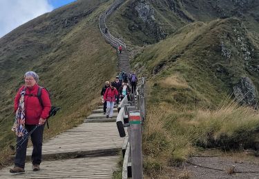
Superbe randonnée avec des paysages magnifiques. La montée à l'ombre est appréciable. Hormis le dénivelé qui peut en rebuter certains, pas de difficulté sur le parcours.


Trails nearby

Trail Walking Mont-Dore - Montée au sommet du Puy de Sancy - Photo
Walking
GUIDE
pscheven

Walking

Easy
(1)
Mont-Dore, Auvergne-Rhône-Alpes, Puy-de-Dôme, France
1.4 km | 2.7 km-effort
40min
Yes
Trail Walking Chambon-sur-Lac - Chambon_Couze_Surains - Photo
Walking
GUIDE
jagarnier

Walking

Medium
(1)
Chambon-sur-Lac, Auvergne-Rhône-Alpes, Puy-de-Dôme, France
11.4 km | 16.6 km-effort
3h 30min
Yes
Trail Walking Mont-Dore - Mont_Dore_Puy_Sancy - Photo
Walking
GUIDE
jagarnier

Walking

Difficult
(1)
Mont-Dore, Auvergne-Rhône-Alpes, Puy-de-Dôme, France
6.8 km | 13.9 km-effort
2h 0min
Yes
Trail Walking Chambon-sur-Lac - Chambon_Moneaux - Photo
Walking
GUIDE
jagarnier

Walking

Medium
(1)
Chambon-sur-Lac, Auvergne-Rhône-Alpes, Puy-de-Dôme, France
15.5 km | 22 km-effort
4h 45min
Yes
Trail Walking Chambon-sur-Lac - Chambon_Vallee_Chaudefour_2 - Photo
Walking
GUIDE
jagarnier

Walking

Difficult
(1)
Chambon-sur-Lac, Auvergne-Rhône-Alpes, Puy-de-Dôme, France
15 km | 26 km-effort
4h 30min
Yes
Trail Walking Mont-Dore - Le puy de la tache, le lacs servières et guèry par la cascade du Queureuilh depuis l'Escalidou.  - Photo
Walking
loloetienne

Walking

Difficult
(3)
Mont-Dore, Auvergne-Rhône-Alpes, Puy-de-Dôme, France
34 km | 50 km-effort
10h 16min
Yes
Trail Walking Mont-Dore - le sancy du mont dore par le côté ouest puis revenir par le côté est.  - Photo
Walking
loloetienne

Walking

Difficult
(2)
Mont-Dore, Auvergne-Rhône-Alpes, Puy-de-Dôme, France
8.2 km | 15.4 km-effort
3h 5min
Yes
Trail Walking Mont-Dore - Sentier des crêtes Puy de Sancy - Photo
Walking
tracegps

Walking

Difficult
(2)
Mont-Dore, Auvergne-Rhône-Alpes, Puy-de-Dôme, France
26 km | 46 km-effort
9h 0min
Yes
Trail Walking Chambon-sur-Lac - Puy de l'Angle 2740m 11.5.24 - Photo
Walking
GUIDE
fredetpascale

Walking

Medium
Chambon-sur-Lac, Auvergne-Rhône-Alpes, Puy-de-Dôme, France
7.8 km | 15.2 km-effort
2h 30min
Yes


Close
My subscriptions