![](/images/other/stat-length.png)
![Trail Walking Villers-sous-Saint-Leu - Le tir à l'arc de St-Leu - 5,9 km - Photo](https://media.geolcdn.com/t/1900/400/ext.pjpeg?maxdim=2&url=https%3A%2F%2Fstatic1.geolcdn.com%2Fsiteimages%2Fupload%2Ffiles%2F1553511878bg_sport_marche.png)
Le tir à l'arc de St-Leu - 5,9 km
Pousscailleux
User
![Length](/images/other/stat-length.png)
Length
5.9 km
![Max alt](https://static1.geolcdn.com/siteimages/upload/files/1508320355ic_sort_altitude_max_24dp.png)
Max alt
77 m
![Uphill gradient](https://static1.geolcdn.com/siteimages/upload/files/1508320355ic_sort_den_pos_24dp.png)
Uphill gradient
72 m
![Km-Effort](/images/other/stat-length.png)
Km-Effort
6.8 km
![Min alt](https://static1.geolcdn.com/siteimages/upload/files/1508320355ic_sort_altitude_min_24dp.png)
Min alt
32 m
![Downhill gradient](https://static1.geolcdn.com/siteimages/upload/files/1508320355ic_sort_den_neg_24dp.png)
Downhill gradient
70 m
![Boucle](https://static1.geolcdn.com/siteimages/upload/files/16400158638029165_repeat_loop_refresh_sync_direction_icon.png)
Boucle
Yes
Creation date :
2014-12-10 00:00:00.0
Updated on :
2022-11-28 13:43:48.976
![Walking](https://static1.geolcdn.com/sitytour/trail-icons/101.png)
1h12
Difficulty : Easy
![Scan this QR Code to open this trail in the SityTrail application](https://capi.geolives.com/qq0zvz2zws4bq2lad0pu/sitytour/trails/187874/qr.png?size=200)
FREE GPS app for hiking
About
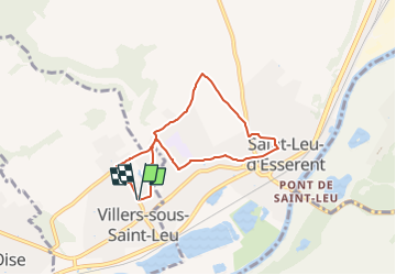
Trail Walking of 5.9 km to be discovered at Hauts-de-France, Oise, Villers-sous-Saint-Leu. This trail is proposed by Pousscailleux.
Description
Départ : Parking du Foyer Rural de Villers-sous-Saint-Leu.
Par le fosse aux Lièvres et le GR11, puis la sente Francois Villon
Positioning
Country:
France
Region :
Hauts-de-France
Department/Province :
Oise
Municipality :
Villers-sous-Saint-Leu
Location:
Unknown
Start:(Dec)
Start:(UTM)
456200 ; 5451277 (31U) N.
Comments
Trails nearby
![Trail Walking Boran-sur-Oise - randonnée abbaye de Royaumont - Photo](https://media.geolcdn.com/t/375/260/9e39e4a0-eda1-4b72-bd45-4ab1609b4c88.jpg&format=jpg&maxdim=2)
![Walking Walking](https://static1.geolcdn.com/sitytour/trail-icons/101.png)
randonnée abbaye de Royaumont
Walking
Difficult
(1)
Boran-sur-Oise,
Hauts-de-France,
Oise,
France
![](/images/other/stat-length.png)
13.2 km | 14.5 km-effort
3h 8min
![](https://static1.geolcdn.com/siteimages/upload/files/16400158638029165_repeat_loop_refresh_sync_direction_icon.png)
Yes
![Trail Mountain bike Montataire - Rando des Forges 2012 - Montataire - Photo](https://media.geolcdn.com/t/375/260/ext.jpg?maxdim=2&url=https%3A%2F%2Fstatic1.geolcdn.com%2Fsiteimages%2Fupload%2Ffiles%2F1524743154velo.jpg)
![Mountain bike Mountain bike](https://static1.geolcdn.com/sitytour/trail-icons/202.png)
Rando des Forges 2012 - Montataire
Mountain bike
Medium
(1)
Montataire,
Hauts-de-France,
Oise,
France
![](/images/other/stat-length.png)
43 km | 51 km-effort
2h 30min
![](https://static1.geolcdn.com/siteimages/upload/files/16400158638029165_repeat_loop_refresh_sync_direction_icon.png)
Yes
![Trail Walking Chantilly - chantilly Gouvieux - Photo](https://media.geolcdn.com/t/375/260/473182f7-0abd-45e5-a275-6e4137d40dac.jpg&format=jpg&maxdim=2)
![Walking Walking](https://static1.geolcdn.com/sitytour/trail-icons/101.png)
chantilly Gouvieux
Walking
Easy
Chantilly,
Hauts-de-France,
Oise,
France
![](/images/other/stat-length.png)
20 km | 0 m-effort
5h 59min
![](https://static1.geolcdn.com/siteimages/upload/files/16400158638029165_repeat_loop_refresh_sync_direction_icon.png)
Yes
![Trail Walking Boran-sur-Oise - boran Le Lys - Photo](https://media.geolcdn.com/t/375/260/4819a07e-0b5c-4197-bc24-63181ff51320.jpg&format=jpg&maxdim=2)
![Walking Walking](https://static1.geolcdn.com/sitytour/trail-icons/101.png)
boran Le Lys
Walking
Very easy
Boran-sur-Oise,
Hauts-de-France,
Oise,
France
![](/images/other/stat-length.png)
11.8 km | 12.8 km-effort
2h 58min
![](https://static1.geolcdn.com/siteimages/upload/files/16400158638029165_repeat_loop_refresh_sync_direction_icon.png)
Yes
![Trail Walking Précy-sur-Oise - randonnée de precy au bois st Michel - Photo](https://media.geolcdn.com/t/375/260/d7a9f220-2cc5-4d20-beb1-6ffb9d61217a.jpg&format=jpg&maxdim=2)
![Walking Walking](https://static1.geolcdn.com/sitytour/trail-icons/101.png)
randonnée de precy au bois st Michel
Walking
Medium
Précy-sur-Oise,
Hauts-de-France,
Oise,
France
![](/images/other/stat-length.png)
11.6 km | 14.2 km-effort
2h 47min
![](https://static1.geolcdn.com/siteimages/upload/files/16400158638029165_repeat_loop_refresh_sync_direction_icon.png)
Yes
![Trail Walking Saint-Leu-d'Esserent - CRAB : Saint Leu d'Esserent - Photo](https://media.geolcdn.com/t/375/260/ext.jpg?maxdim=2&url=https%3A%2F%2Fservices.sitytrail.com%2FGeolivesWS%2FDownloadMedia.ashx%3FTrailID%3D656888%26Media%3Dfix__20161106164744.jpg)
![Walking Walking](https://static1.geolcdn.com/sitytour/trail-icons/101.png)
CRAB : Saint Leu d'Esserent
Walking
Easy
Saint-Leu-d'Esserent,
Hauts-de-France,
Oise,
France
![](/images/other/stat-length.png)
24 km | 28 km-effort
6h 7min
![](https://static1.geolcdn.com/siteimages/upload/files/16400158638029165_repeat_loop_refresh_sync_direction_icon.png)
Yes
![Trail Walking Villers-sous-Saint-Leu - THIVERNY_12,6 km_Trace GPS - Photo](https://media.geolcdn.com/t/375/260/ext.jpg?maxdim=2&url=https%3A%2F%2Fservices.sitytrail.com%2FGeolivesWS%2FDownloadMedia.ashx%3FTrailID%3D189132%26Media%3D20130505092004.jpeg)
![Walking Walking](https://static1.geolcdn.com/sitytour/trail-icons/101.png)
THIVERNY_12,6 km_Trace GPS
Walking
Medium
Villers-sous-Saint-Leu,
Hauts-de-France,
Oise,
France
![](/images/other/stat-length.png)
12.6 km | 14.7 km-effort
2h 56min
![](https://static1.geolcdn.com/siteimages/upload/files/16400158638029165_repeat_loop_refresh_sync_direction_icon.png)
Yes
![Trail Walking Villers-sous-Saint-Leu - La Rive des Moines - 9,6 km - Photo](https://media.geolcdn.com/t/375/260/ext.jpg?maxdim=2&url=https%3A%2F%2Fstatic1.geolcdn.com%2Fsiteimages%2Fupload%2Ffiles%2F1553511878bg_sport_marche.png)
![Walking Walking](https://static1.geolcdn.com/sitytour/trail-icons/101.png)
La Rive des Moines - 9,6 km
Walking
Easy
(1)
Villers-sous-Saint-Leu,
Hauts-de-France,
Oise,
France
![](/images/other/stat-length.png)
9.6 km | 11.3 km-effort
1h 58min
![](https://static1.geolcdn.com/siteimages/upload/files/16400158638029165_repeat_loop_refresh_sync_direction_icon.png)
Yes
![Trail Walking Montataire - Montataire - Photo](https://media.geolcdn.com/t/375/260/4bd814d9-48d9-47fd-8f11-f49f7a9caae2.jpg&format=jpg&maxdim=2)
![Walking Walking](https://static1.geolcdn.com/sitytour/trail-icons/101.png)