![](/images/other/stat-length.png)
![Trail Walking Valensole - Valensole N-O - Photo](https://media.geolcdn.com/t/1900/400/ext.pjpeg?maxdim=2&url=https%3A%2F%2Fstatic1.geolcdn.com%2Fsiteimages%2Fupload%2Ffiles%2F1553511878bg_sport_marche.png)
Valensole N-O
Jacot33
User
![Length](/images/other/stat-length.png)
Length
16.9 km
![Max alt](https://static1.geolcdn.com/siteimages/upload/files/1508320355ic_sort_altitude_max_24dp.png)
Max alt
597 m
![Uphill gradient](https://static1.geolcdn.com/siteimages/upload/files/1508320355ic_sort_den_pos_24dp.png)
Uphill gradient
297 m
![Km-Effort](/images/other/stat-length.png)
Km-Effort
21 km
![Min alt](https://static1.geolcdn.com/siteimages/upload/files/1508320355ic_sort_altitude_min_24dp.png)
Min alt
531 m
![Downhill gradient](https://static1.geolcdn.com/siteimages/upload/files/1508320355ic_sort_den_neg_24dp.png)
Downhill gradient
294 m
![Boucle](https://static1.geolcdn.com/siteimages/upload/files/16400158638029165_repeat_loop_refresh_sync_direction_icon.png)
Boucle
Yes
Creation date :
2014-12-10 00:00:00.0
Updated on :
2014-12-10 00:00:00.0
![Walking](https://static1.geolcdn.com/sitytour/trail-icons/101.png)
2h00
Difficulty : Easy
![Scan this QR Code to open this trail in the SityTrail application](https://capi.geolives.com/qq0zvz2zws4bq2lad0pu/sitytour/trails/185687/qr.png?size=200)
FREE GPS app for hiking
About
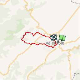
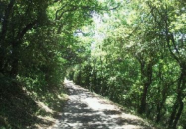
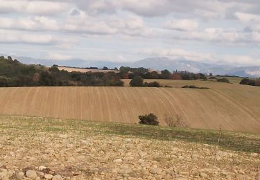
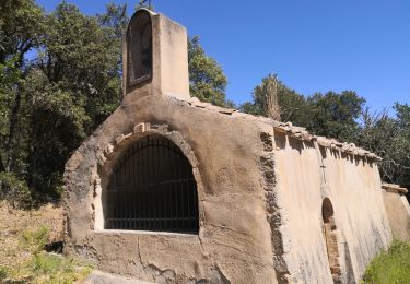
Trail Walking of 16.9 km to be discovered at Provence-Alpes-Côte d'Azur, Alpes-de-Haute-Provence, Valensole. This trail is proposed by Jacot33.
Description
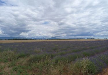
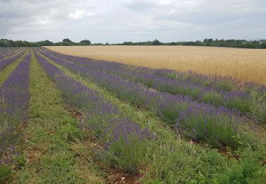
Randonnée facile sur le plateau de Valensole, au milieu des champs de lavandes. Boucle empruntant des portions de sentiers de randonnées locaux.
Points of interest
Positioning
Country:
France
Region :
Provence-Alpes-Côte d'Azur
Department/Province :
Alpes-de-Haute-Provence
Municipality :
Valensole
Location:
Unknown
Start:(Dec)
Start:(UTM)
740146 ; 4858064 (31T) N.
Comments
Trails nearby
![Trail Walking Valensole - Valensole 23.6.24 - Photo](https://media.geolcdn.com/t/375/260/c5e327a9-dd5d-45ba-9909-cbfe5f867953.jpg&format=jpg&maxdim=2)
![Walking Walking](https://static1.geolcdn.com/sitytour/trail-icons/101.png)
Valensole 23.6.24
Walking
Medium
Valensole,
Provence-Alpes-Côte d'Azur,
Alpes-de-Haute-Provence,
France
![](/images/other/stat-length.png)
15 km | 19.1 km-effort
4h 0min
![](https://static1.geolcdn.com/siteimages/upload/files/16400158638029165_repeat_loop_refresh_sync_direction_icon.png)
Yes
![Trail Walking Valensole - TOUR DESLAVANDES A VALENSOLE - Photo](https://media.geolcdn.com/t/375/260/ext.jpg?maxdim=2&url=https%3A%2F%2Fstatic1.geolcdn.com%2Fsiteimages%2Fupload%2Ffiles%2F1553511878bg_sport_marche.png)
![Walking Walking](https://static1.geolcdn.com/sitytour/trail-icons/101.png)
TOUR DESLAVANDES A VALENSOLE
Walking
Very easy
(1)
Valensole,
Provence-Alpes-Côte d'Azur,
Alpes-de-Haute-Provence,
France
![](/images/other/stat-length.png)
14.7 km | 17.5 km-effort
4h 26min
![](https://static1.geolcdn.com/siteimages/upload/files/16400158638029165_repeat_loop_refresh_sync_direction_icon.png)
Yes
![Trail Walking Valensole - nocturne du nouvel an 2025 - Photo](https://media.geolcdn.com/t/375/260/f84b02f9-f7fa-430c-9c2e-cb601163687e.jpg&format=jpg&maxdim=2)
![Walking Walking](https://static1.geolcdn.com/sitytour/trail-icons/101.png)
nocturne du nouvel an 2025
Walking
Easy
Valensole,
Provence-Alpes-Côte d'Azur,
Alpes-de-Haute-Provence,
France
![](/images/other/stat-length.png)
4.8 km | 5.8 km-effort
1h 32min
![](https://static1.geolcdn.com/siteimages/upload/files/16400158638029165_repeat_loop_refresh_sync_direction_icon.png)
Yes
![Trail Walking Valensole - plateau de valensole . ravin des cognets . ravin de la combe - Photo](https://media.geolcdn.com/t/375/260/e70e2dd7-3984-4b6a-b8f2-66f7c2ecda80.jpg&format=jpg&maxdim=2)
![Walking Walking](https://static1.geolcdn.com/sitytour/trail-icons/101.png)
plateau de valensole . ravin des cognets . ravin de la combe
Walking
Easy
Valensole,
Provence-Alpes-Côte d'Azur,
Alpes-de-Haute-Provence,
France
![](/images/other/stat-length.png)
11.2 km | 13.1 km-effort
4h 11min
![](https://static1.geolcdn.com/siteimages/upload/files/16400158638029165_repeat_loop_refresh_sync_direction_icon.png)
Yes
![Trail Walking Valensole - Valensole - L'Adret de Notre Dame - Photo](https://media.geolcdn.com/t/375/260/11a07c96-1b58-4bef-bf06-b0297f57cb83.jpg&format=jpg&maxdim=2)
![Walking Walking](https://static1.geolcdn.com/sitytour/trail-icons/101.png)
Valensole - L'Adret de Notre Dame
Walking
Medium
Valensole,
Provence-Alpes-Côte d'Azur,
Alpes-de-Haute-Provence,
France
![](/images/other/stat-length.png)
8 km | 9.6 km-effort
2h 26min
![](https://static1.geolcdn.com/siteimages/upload/files/16400158638029165_repeat_loop_refresh_sync_direction_icon.png)
Yes
![Trail Walking Valensole - Valensole - Photo](https://media.geolcdn.com/t/375/260/ext.jpg?maxdim=2&url=https%3A%2F%2Fservices.sitytrail.com%2FGeolivesWS%2FDownloadMedia.ashx%3FTrailID%3D137096%26Media%3D20120703150528.jpeg)
![Walking Walking](https://static1.geolcdn.com/sitytour/trail-icons/101.png)
Valensole
Walking
Easy
Valensole,
Provence-Alpes-Côte d'Azur,
Alpes-de-Haute-Provence,
France
![](/images/other/stat-length.png)
9.4 km | 11.5 km-effort
1h 42min
![](https://static1.geolcdn.com/siteimages/upload/files/16400158638029165_repeat_loop_refresh_sync_direction_icon.png)
Yes
![Trail Walking Valensole - valensole. la savoye - Photo](https://media.geolcdn.com/t/375/260/6dde06cf-0ff1-4b73-93f5-42d3f0a2caee.jpg&format=jpg&maxdim=2)
![Walking Walking](https://static1.geolcdn.com/sitytour/trail-icons/101.png)
valensole. la savoye
Walking
Very easy
Valensole,
Provence-Alpes-Côte d'Azur,
Alpes-de-Haute-Provence,
France
![](/images/other/stat-length.png)
6.4 km | 8 km-effort
1h 50min
![](https://static1.geolcdn.com/siteimages/upload/files/16400158638029165_repeat_loop_refresh_sync_direction_icon.png)
Yes
![Trail Walking Valensole - Ravin de la forge et chapelle de la ste Trinité - Photo](https://media.geolcdn.com/t/375/260/3f8ef10d-340b-487b-8be2-0a28a565d455.jpg&format=jpg&maxdim=2)
![Walking Walking](https://static1.geolcdn.com/sitytour/trail-icons/101.png)
Ravin de la forge et chapelle de la ste Trinité
Walking
Very easy
Valensole,
Provence-Alpes-Côte d'Azur,
Alpes-de-Haute-Provence,
France
![](/images/other/stat-length.png)
10 km | 12.3 km-effort
3h 1min
![](https://static1.geolcdn.com/siteimages/upload/files/16400158638029165_repeat_loop_refresh_sync_direction_icon.png)
Yes
![Trail Walking Valensole - Ravin de la Forge et la chapelle de la Trinité - Photo](https://media.geolcdn.com/t/375/260/ext.jpg?maxdim=2&url=https%3A%2F%2Fservices.sitytrail.com%2FGeolivesWS%2FDownloadMedia.ashx%3FTrailID%3D1130823%26Media%3Dfix__20190404155824.jpg)
![Walking Walking](https://static1.geolcdn.com/sitytour/trail-icons/101.png)
Ravin de la Forge et la chapelle de la Trinité
Walking
Medium
Valensole,
Provence-Alpes-Côte d'Azur,
Alpes-de-Haute-Provence,
France
![](/images/other/stat-length.png)
10.8 km | 13.4 km-effort
2h 54min
![](https://static1.geolcdn.com/siteimages/upload/files/16400158638029165_repeat_loop_refresh_sync_direction_icon.png)
No