Trail Other activity Sainte-Croix - Sainte-Croix - Chasseron - Noiraigue 1/2 - Photo

Sainte-Croix - Chasseron - Noiraigue 1/2

 Romrando
Romrando

User

© OpenStreetMap contributors
Length
Length
8.6 km
Max alt
Max alt
1587 m
Uphill gradient
Uphill gradient
670 m
Km-Effort
Km-Effort  
15.8 km
Min alt
Min alt
1069 m
Downhill gradient
Downhill gradient
155 m
Boucle
Boucle
No
Creation date :
2014-12-11 00:00:00.0
Updated on :
2014-12-11 00:00:00.0

(0 Reviews)

Other activity
Other activity
--
Difficulty : Unknown

Scan this QR Code to open this trail in the SityTrail application

FREE GPS app for hiking

Logo SityTrail SityTrail

IGN / Geographical institutes

Download SityTrail from the App Store Download SityTrail from Google Play

Logo SityTrail SityTrail World

The world is yours!

Download SityTrail from the App Store Download SityTrail from Google Play Download SityTrail on Huawei AppGallery

About

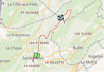
Trail Other activity of 8.6 km to be discovered at Vaud, District du Jura-Nord vaudois, Sainte-Croix. This trail is proposed by Romrando.

Description

Source:geocities.com/romrando

Superbe échappée d''un week-end quand le brouillard occulte la plaine. Terrain assez sauvage sur la 2ème partie.

1er JOUR :
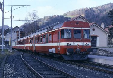
Laisser la voiture à Yverdon puis gagner Ste-Croix par le train.

De Ste-Croix par le nord on gagne à travers champs "Les Praises" puis par chemin horizontal on contourne une colline puis à une bifurcation on prend un chemin à droite qui s''élève vers "Le Sollier". (Attention : Des "Praises" ne pas s''engager à droite dans une pente qui gagne le col au SE de la colline. La pente derrière est difficilement pratiquable voire dangereuse - glissement de plaque !).

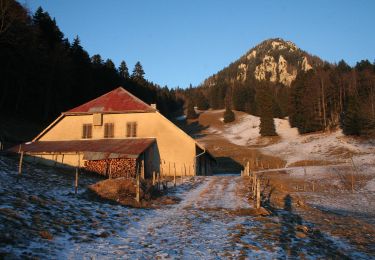
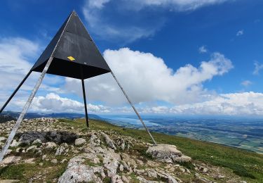
On gagne horizontalement vers le NE "La Merla" puis, toujours à flanc dans un terrain assez raide et difficile vers le NE, on gagne le "Chalet des Roches Eboulées". Monter alors vers l''E pour gagner un petit plateau (point 1''448 m). Traverser celui-ci vers le SW puis par une pente assez raide rejoindre la crête environ 500 m avant le sommet du Chasseron que l''on gagne sans difficulté.

Elevation profile

Positioning

Country:
Switzerland
Region :
Vaud
Department/Province :
District du Jura-Nord vaudois
Municipality :
Sainte-Croix
Location:
Unknown
Start:(UTM)
309373 ; 5188141 (32T) N.

Trails nearby

Trail On foot La Côte-aux-Fées - La Côte-aux-Fées - Buttes - Photo
On foot
PRO

On foot

Easy
La Côte-aux-Fées, Neuchâtel, Unknown, Switzerland
6.7 km | 8.5 km-effort
1h 55min
No
Trail On foot Sainte-Croix - La Gittaz-Col de l'Aigullon - Photo
On foot
PRO

On foot

Easy
Sainte-Croix, Vaud, District du Jura-Nord vaudois, Switzerland
4.1 km | 6.4 km-effort
1h 26min
No
Trail On foot Sainte-Croix - Sainte Croix-La Gittaz - Photo
On foot
PRO

On foot

Easy
Sainte-Croix, Vaud, District du Jura-Nord vaudois, Switzerland
5.7 km | 8.3 km-effort
1h 53min
No
Trail On foot Sainte-Croix - Chemin de la Gare - Photo
On foot
PRO

On foot

Easy
Sainte-Croix, Vaud, District du Jura-Nord vaudois, Switzerland
6.5 km | 8.6 km-effort
1h 57min
No
Trail Walking Jougne - Aiguilles de Baulmes - Suisse - Photo
Walking
albert39

Walking

Difficult
(1)
Jougne, Bourgogne-Franche-Comté, Doubs, France
16.4 km | 26 km-effort
5h 33min
Yes
Trail Walking Sainte-Croix - le Chasseron par les avattes - Photo
Walking
viam19

Walking

Medium
Sainte-Croix, Vaud, District du Jura-Nord vaudois, Switzerland
13.3 km | 20 km-effort
4h 18min
Yes
Trail Walking Jougne - aiguilles de Baulmes et retour  Suchet  - Photo
Walking
BM25

Walking

Very easy
Jougne, Bourgogne-Franche-Comté, Doubs, France
23 km | 37 km-effort
6h 31min
Yes
Trail Snowshoes Sainte-Croix - Col des Etroits Le Chasseron CAF - Photo
Snowshoes
TRIMAILLE

Snowshoes

Difficult
Sainte-Croix, Vaud, District du Jura-Nord vaudois, Switzerland
12.2 km | 19.9 km-effort
Unknown
Yes
Trail Walking Sainte-Croix - Sentier des bornes sud  - Photo
Walking
mallovon

Walking

Very easy
Sainte-Croix, Vaud, District du Jura-Nord vaudois, Switzerland
6.7 km | 8.7 km-effort
2h 46min
Yes


Close
My subscriptions