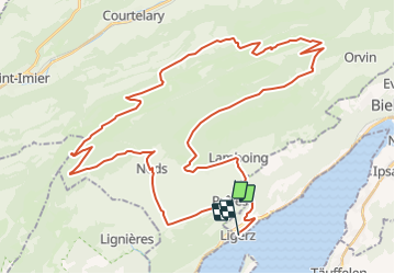
![](/images/other/stat-length.png)
![Trail Winter sports Plateau de Diesse - Chasseral - route des métairies - Photo](https://media.geolcdn.com/t/1900/400/ext.pjpeg?maxdim=2&url=https%3A%2F%2Fstatic1.geolcdn.com%2Fsiteimages%2Fupload%2Ffiles%2F1524743153ski.jpg)
Chasseral - route des métairies
Romrando
User
![Length](/images/other/stat-length.png)
![Max alt](https://static1.geolcdn.com/siteimages/upload/files/1508320355ic_sort_altitude_max_24dp.png)
![Uphill gradient](https://static1.geolcdn.com/siteimages/upload/files/1508320355ic_sort_den_pos_24dp.png)
![Km-Effort](/images/other/stat-length.png)
![Min alt](https://static1.geolcdn.com/siteimages/upload/files/1508320355ic_sort_altitude_min_24dp.png)
![Downhill gradient](https://static1.geolcdn.com/siteimages/upload/files/1508320355ic_sort_den_neg_24dp.png)
![Boucle](https://static1.geolcdn.com/siteimages/upload/files/16400158638029165_repeat_loop_refresh_sync_direction_icon.png)
![Winter sports](https://static1.geolcdn.com/sitytour/trail-icons/500.png)
--
Difficulty : Unknown
![Scan this QR Code to open this trail in the SityTrail application](https://capi.geolives.com/qq0zvz2zws4bq2lad0pu/sitytour/trails/18552/qr.png?size=200)
FREE GPS app for hiking
About
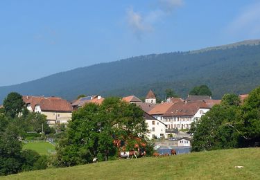
Trail Winter sports of 52 km to be discovered at Bern, Bernese Jura administrative district, Plateau de Diesse. This trail is proposed by Romrando.
Description
Source:geocities.com/romrando
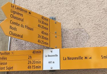
Dès la sortie du village de Prêles prendre à gauche une petite route que l''on suit sur 3 km puis à droite directement sur Nods. Suivre alors une petite route qui mène en quatre lacets au sommet du Chasseral (>> puis >>> par moments).
Passer vers l''hôtel puis avant l''immense antenne piquer à gauche et descendre dans une combe vers une ferme. Toujours vers le NE franchir la crête (>>) puis descendre vers la Métairie de Morat. Par une combe et un chemin caillouteux on rejoint une route en terre.
Prendre sur la gauche dans un vallon puis vers la droite jusqu''au Prés de Cortébert avant de gagner un défilé sur la droite pour franchir le Pont des Anabaptistes. Remonter vers la gauche et gagner la Métairie de Gléresse (Restauration en été).
Poursuivre vers l''ENE par un chemin caillouteux on passe à la Métairie de Diesse puis on arrive à la ferme "Jobert". Partir alors vers l''E, franchir la crête puis descendre en quelques lacets sur les Prés d''Orvin.
On rejoint une petite route que l''on suit en montée vers le WSW (>) puis on part à gauche vers le SW juste avant la Métairie de Prêles. On coutourne le Mont Sujet par l''W puis on rejoint Diesse et Lamboing. Descendre les gorges de Twann sur 1 km et prendre à droite un chemin qui traverse la rivière et rejoint Gléresse par la rive droite.
Positioning
Comments
Trails nearby
![Trail On foot Twann-Tüscherz - Bielersee Heidenweg - Photo](https://media.geolcdn.com/t/375/260/d073d6a0-d3fc-4691-8384-c343898e7cf3.jpeg&format=jpg&maxdim=2)
![On foot On foot](https://static1.geolcdn.com/sitytour/trail-icons/100.png)
On foot
![](/images/other/stat-length.png)
![](https://static1.geolcdn.com/siteimages/upload/files/16400158638029165_repeat_loop_refresh_sync_direction_icon.png)
![Trail On foot La Neuveville - La Neuveville - Lignières - Photo](https://media.geolcdn.com/t/375/260/8efce415-6640-430b-a3ed-8ab0638b4b45.jpeg&format=jpg&maxdim=2)
![On foot On foot](https://static1.geolcdn.com/sitytour/trail-icons/100.png)
On foot
![](/images/other/stat-length.png)
![](https://static1.geolcdn.com/siteimages/upload/files/16400158638029165_repeat_loop_refresh_sync_direction_icon.png)
![Trail On foot Evilard - Hohmatt - fixme - Photo](https://media.geolcdn.com/t/375/260/29ecf5fc-0e21-436a-97ef-7bee2bdcdbae.jpeg&format=jpg&maxdim=2)
![On foot On foot](https://static1.geolcdn.com/sitytour/trail-icons/100.png)
On foot
![](/images/other/stat-length.png)
![](https://static1.geolcdn.com/siteimages/upload/files/16400158638029165_repeat_loop_refresh_sync_direction_icon.png)
![Trail On foot Nods - Nods Pierre Grise - Chasseral Hôtel - Photo](https://media.geolcdn.com/t/375/260/d0e46239-22d1-4c02-a179-de1da09817b4.jpeg&format=jpg&maxdim=2)
![On foot On foot](https://static1.geolcdn.com/sitytour/trail-icons/100.png)
On foot
![](/images/other/stat-length.png)
![](https://static1.geolcdn.com/siteimages/upload/files/16400158638029165_repeat_loop_refresh_sync_direction_icon.png)
![Trail On foot Nods - Nods - Prés Vaillons - Photo](https://media.geolcdn.com/t/375/260/d0e46239-22d1-4c02-a179-de1da09817b4.jpeg&format=jpg&maxdim=2)
![On foot On foot](https://static1.geolcdn.com/sitytour/trail-icons/100.png)
On foot
![](/images/other/stat-length.png)
![](https://static1.geolcdn.com/siteimages/upload/files/16400158638029165_repeat_loop_refresh_sync_direction_icon.png)
![Trail On foot La Neuveville - Festi - fixme - Photo](https://media.geolcdn.com/t/375/260/1ec500ec-828b-4769-bcce-fdfd731779b5.jpeg&format=jpg&maxdim=2)
![On foot On foot](https://static1.geolcdn.com/sitytour/trail-icons/100.png)
On foot
![](/images/other/stat-length.png)
![](https://static1.geolcdn.com/siteimages/upload/files/16400158638029165_repeat_loop_refresh_sync_direction_icon.png)
![Trail Walking La Neuveville - La Neuveville-Ile de St-Pierre - Photo](https://media.geolcdn.com/t/375/260/ext.jpg?maxdim=2&url=https%3A%2F%2Fstatic1.geolcdn.com%2Fsiteimages%2Fupload%2Ffiles%2F1553511878bg_sport_marche.png)
![Walking Walking](https://static1.geolcdn.com/sitytour/trail-icons/101.png)
Walking
![](/images/other/stat-length.png)
![](https://static1.geolcdn.com/siteimages/upload/files/16400158638029165_repeat_loop_refresh_sync_direction_icon.png)
![Trail On foot Plateau de Diesse - Lamboing - Pt 1290 - Photo](https://media.geolcdn.com/t/375/260/ec5bef30-d885-47d1-b61b-5de7c329435c.jpeg&format=jpg&maxdim=2)
![On foot On foot](https://static1.geolcdn.com/sitytour/trail-icons/100.png)
On foot
![](/images/other/stat-length.png)
![](https://static1.geolcdn.com/siteimages/upload/files/16400158638029165_repeat_loop_refresh_sync_direction_icon.png)