Trail Winter sports Ballaigues - Lausanne-Yverdon (parcours inédit) - 3/4 - Photo

Lausanne-Yverdon (parcours inédit) - 3/4

 Romrando
Romrando

User

© OpenStreetMap contributors
Length
Length
18.3 km
Max alt
Max alt
1397 m
Uphill gradient
Uphill gradient
722 m
Km-Effort
Km-Effort  
27 km
Min alt
Min alt
863 m
Downhill gradient
Downhill gradient
544 m
Boucle
Boucle
No
Creation date :
2014-12-11 00:00:00.0
Updated on :
2014-12-11 00:00:00.0

(0 Reviews)

Winter sports
Winter sports
--
Difficulty : Unknown

Scan this QR Code to open this trail in the SityTrail application

FREE GPS app for hiking

Logo SityTrail SityTrail

IGN / Geographical institutes

Download SityTrail from the App Store Download SityTrail from Google Play

Logo SityTrail SityTrail World

The world is yours!

Download SityTrail from the App Store Download SityTrail from Google Play Download SityTrail on Huawei AppGallery

About

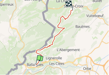
Trail Winter sports of 18.3 km to be discovered at Vaud, District du Jura-Nord vaudois, Ballaigues. This trail is proposed by Romrando.

Description

Source:geocities.com/romrando

Lausanne - Yverdon - 3/4

Partie 3 : Ballaigues - Ste-Croix

De Ballaigues remonter une petite route pour gagner "La Bessone" (>>>). Au carrefour prendre à gauche sur 400m puis à droite on rejoint l''alpage de "La Tiole". (Restauration, cadre sympa, réservation recommandée).

Rejoindre la route et continuer d''abord vers le NW par une route carrossable puis vers le NE (>>) pour monter sur le le Bel Coster (coup d''oeils magnifiques). On descend ensuite sur "La Poyette". Par le nord on contourne tout le Suchet par une succession de chemins plus ou moins bons. On atteint l''alpage de "Grange Neuve" (restauration, très fréquenté).

Descendre la route juqu''à la croisée puis prendre à gauche et franchir le col de l''Aiguillon. Redescendre vers le NE et  500 m après "La Gite Dessus" prendre à droite un chemin qui descend "La Sagne".

Elevation profile

Positioning

Country:
Switzerland
Region :
Vaud
Department/Province :
District du Jura-Nord vaudois
Municipality :
Ballaigues
Location:
Unknown
Start:(Dec)
Start:(UTM)
302557 ; 5178370 (32T) N.

Trails nearby

Trail Mountain bike Vallorbe - Le Suchet - Photo
Mountain bike
GUIDE+

Mountain bike

Very easy
(1)
Vallorbe, Vaud, District du Jura-Nord vaudois, Switzerland
35 km | 53 km-effort
14h 41min
Yes
Trail On foot Les Clées - fixme - fixme - Photo
On foot
GUIDE+

On foot

Easy
Les Clées, Vaud, District du Jura-Nord vaudois, Switzerland
4.1 km | 5.9 km-effort
1h 20min
No
Trail On foot Les Clées - Tourisme pédestre - Photo
On foot
GUIDE+

On foot

Easy
Les Clées, Vaud, District du Jura-Nord vaudois, Switzerland
3.5 km | 4.5 km-effort
1h 0min
No
Trail On foot Ballaigues - Ballaigues-Vallorbe - Photo
On foot
GUIDE+

On foot

Easy
Ballaigues, Vaud, District du Jura-Nord vaudois, Switzerland
5.1 km | 6.3 km-effort
1h 25min
No
Trail On foot Juriens - TP Mollendruz - Romainmôtie - Photo
On foot
GUIDE+

On foot

Easy
Juriens, Vaud, District du Jura-Nord vaudois, Switzerland
7.8 km | 11.6 km-effort
2h 38min
No
Trail Walking Métabief - GTJ  Metabief - Pontarlier - Photo
Walking
svp59

Walking

Medium
(1)
Métabief, Bourgogne-Franche-Comté, Doubs, France
25 km | 35 km-effort
7h 17min
No
Trail Walking Métabief - Le mont d 0r - Photo
Walking
jjjf01

Walking

Medium
Métabief, Bourgogne-Franche-Comté, Doubs, France
18.5 km | 25 km-effort
4h 38min
No
Trail Walking Jougne - La Jougnena - Photo
Walking
daniellebou

Walking

Very difficult
(1)
Jougne, Bourgogne-Franche-Comté, Doubs, France
17.7 km | 24 km-effort
5h 32min
Yes
Trail Walking Jougne - La poyette - Photo
Walking
mallovon

Walking

Medium
Jougne, Bourgogne-Franche-Comté, Doubs, France
11.8 km | 17.9 km-effort
4h 7min
Yes


Close
My subscriptions