![](/images/other/stat-length.png)
![Trail Other activity Finhaut - Cheval Blanc (2''830 m) - Photo](https://media.geolcdn.com/t/1900/400/ext.pjpeg?maxdim=2&url=https%3A%2F%2Fstatic1.geolcdn.com%2Fsiteimages%2Fupload%2Ffiles%2F1545311037marcheuse_200dpi.jpg)
Cheval Blanc (2''830 m)
Romrando
User
![Length](/images/other/stat-length.png)
![Max alt](https://static1.geolcdn.com/siteimages/upload/files/1508320355ic_sort_altitude_max_24dp.png)
![Uphill gradient](https://static1.geolcdn.com/siteimages/upload/files/1508320355ic_sort_den_pos_24dp.png)
![Km-Effort](/images/other/stat-length.png)
![Min alt](https://static1.geolcdn.com/siteimages/upload/files/1508320355ic_sort_altitude_min_24dp.png)
![Downhill gradient](https://static1.geolcdn.com/siteimages/upload/files/1508320355ic_sort_den_neg_24dp.png)
![Boucle](https://static1.geolcdn.com/siteimages/upload/files/16400158638029165_repeat_loop_refresh_sync_direction_icon.png)
![Other activity](https://static1.geolcdn.com/sitytour/trail-icons/900.png)
--
Difficulty : Unknown
![Scan this QR Code to open this trail in the SityTrail application](https://capi.geolives.com/qq0zvz2zws4bq2lad0pu/sitytour/trails/18539/qr.png?size=200)
FREE GPS app for hiking
About
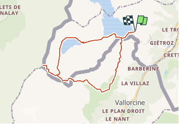
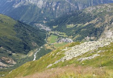
Trail Other activity of 16.2 km to be discovered at Valais/Wallis, Saint-Maurice, Finhaut. This trail is proposed by Romrando.
Description
Source:geocities.com/romrando
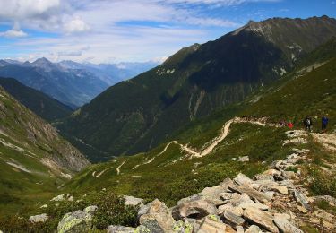
Randonnée remarquable par son ambiance et ses points de vue exceptionnels sur le massif du Mont-Blanc.
Depuis la Geulaz (barrage d''Emosson) vers le SW, on rejoint le barrage et le lac du Vieux-Emosson que l''on contourne par l''W.
On gagne le col du Vieux à l''W du site des traces des dinosaures, puis on rejoint le sommet du Cheval Blanc par un raide sentier un peu exposé sur les 50 derniers mètres mais équipé de chaînes.
Retour par le site des dinosaures puis par le franchissement du col de la Terrasse.
Par une raide descente, rejoindre les chalets de Loria. De là vers le N on suit un sentier à flanc qui ramène au barrage d''Emosson.
Positioning
Comments
Trails nearby
![Trail Touring skiing Finhaut - pointe de la terrasse - Photo](https://media.geolcdn.com/t/375/260/d4e5c913-45a8-46a0-b8c1-07b0c700d709.jpg&format=jpg&maxdim=2)
![Touring skiing Touring skiing](https://static1.geolcdn.com/sitytour/trail-icons/503.png)
Touring skiing
![](/images/other/stat-length.png)
![](https://static1.geolcdn.com/siteimages/upload/files/16400158638029165_repeat_loop_refresh_sync_direction_icon.png)
![Trail Walking Vallorcine - téléphérique Vallorcine,col de Balme,aiguillettes des Posettes Montroc - Photo](https://media.geolcdn.com/t/375/260/34060c99-f20f-4c26-93e7-06e0c904c0b9.jpg&format=jpg&maxdim=2)
![Walking Walking](https://static1.geolcdn.com/sitytour/trail-icons/101.png)
Walking
![](/images/other/stat-length.png)
![](https://static1.geolcdn.com/siteimages/upload/files/16400158638029165_repeat_loop_refresh_sync_direction_icon.png)
![Trail On foot Vallorcine - Chalet de Loriaz - Photo](https://media.geolcdn.com/t/375/260/c078a892-64c2-440e-a24a-1e74f82d7a2b.jpeg&format=jpg&maxdim=2)
![On foot On foot](https://static1.geolcdn.com/sitytour/trail-icons/100.png)
On foot
![](/images/other/stat-length.png)
![](https://static1.geolcdn.com/siteimages/upload/files/16400158638029165_repeat_loop_refresh_sync_direction_icon.png)
![Trail On foot Trient - Sentier des Alpages - Photo](https://media.geolcdn.com/t/375/260/2d94fac1-b61d-463c-b3fe-e4184ed18b6d.jpeg&format=jpg&maxdim=2)
![On foot On foot](https://static1.geolcdn.com/sitytour/trail-icons/100.png)
On foot
![](/images/other/stat-length.png)
![](https://static1.geolcdn.com/siteimages/upload/files/16400158638029165_repeat_loop_refresh_sync_direction_icon.png)
![Trail Walking Vallorcine - Vallorcine a la cascade de Barberine - Photo](https://media.geolcdn.com/t/375/260/c68a506e-06c6-4e48-ac4a-ff4c72fdab58.jpg&format=jpg&maxdim=2)
![Walking Walking](https://static1.geolcdn.com/sitytour/trail-icons/101.png)
Walking
![](/images/other/stat-length.png)
![](https://static1.geolcdn.com/siteimages/upload/files/16400158638029165_repeat_loop_refresh_sync_direction_icon.png)
![Trail Walking Trient - TMB J2 TRIENT - CHAMPEX - Photo](https://media.geolcdn.com/t/375/260/ext.jpg?maxdim=2&url=https%3A%2F%2Fservices.sitytrail.com%2FGeolivesWS%2FDownloadMedia.ashx%3FTrailID%3D594960%26Media%3Dfix__20160704115027.jpg)
![Walking Walking](https://static1.geolcdn.com/sitytour/trail-icons/101.png)
Walking
![](/images/other/stat-length.png)
![](https://static1.geolcdn.com/siteimages/upload/files/16400158638029165_repeat_loop_refresh_sync_direction_icon.png)
![Trail Walking Trient - TMB day 6 - Photo](https://media.geolcdn.com/t/375/260/ext.jpg?maxdim=2&url=https%3A%2F%2Fservices.sitytrail.com%2FGeolivesWS%2FDownloadMedia.ashx%3FTrailID%3D477617%26Media%3Dfix__20150926142604.jpg)
![Walking Walking](https://static1.geolcdn.com/sitytour/trail-icons/101.png)
Walking
![](/images/other/stat-length.png)
![](https://static1.geolcdn.com/siteimages/upload/files/16400158638029165_repeat_loop_refresh_sync_direction_icon.png)
![Trail Walking Vallorcine - Refuge de Loriaz - Photo](https://media.geolcdn.com/t/375/260/ext.jpg?maxdim=2&url=https%3A%2F%2Fstatic1.geolcdn.com%2Fsiteimages%2Fupload%2Ffiles%2F1553511878bg_sport_marche.png)
![Walking Walking](https://static1.geolcdn.com/sitytour/trail-icons/101.png)
Walking
![](/images/other/stat-length.png)
![](https://static1.geolcdn.com/siteimages/upload/files/16400158638029165_repeat_loop_refresh_sync_direction_icon.png)
![Trail Walking Vallorcine - a Albert Premier 20150721 - Photo](https://media.geolcdn.com/t/375/260/ext.jpg?maxdim=2&url=https%3A%2F%2Fservices.sitytrail.com%2FGeolivesWS%2FDownloadMedia.ashx%3FTrailID%3D448295%26Media%3Dfix__20150721135325.jpg)
![Walking Walking](https://static1.geolcdn.com/sitytour/trail-icons/101.png)
Walking
![](/images/other/stat-length.png)
![](https://static1.geolcdn.com/siteimages/upload/files/16400158638029165_repeat_loop_refresh_sync_direction_icon.png)