![](/images/other/stat-length.png)
![Trail Other activity Montreux - Cape au Moine (1''941 m) - Photo](https://media.geolcdn.com/t/1900/400/ext.pjpeg?maxdim=2&url=https%3A%2F%2Fstatic1.geolcdn.com%2Fsiteimages%2Fupload%2Ffiles%2F1545311037marcheuse_200dpi.jpg)
Cape au Moine (1''941 m)
Romrando
User
![Length](/images/other/stat-length.png)
![Max alt](https://static1.geolcdn.com/siteimages/upload/files/1508320355ic_sort_altitude_max_24dp.png)
![Uphill gradient](https://static1.geolcdn.com/siteimages/upload/files/1508320355ic_sort_den_pos_24dp.png)
![Km-Effort](/images/other/stat-length.png)
![Min alt](https://static1.geolcdn.com/siteimages/upload/files/1508320355ic_sort_altitude_min_24dp.png)
![Downhill gradient](https://static1.geolcdn.com/siteimages/upload/files/1508320355ic_sort_den_neg_24dp.png)
![Boucle](https://static1.geolcdn.com/siteimages/upload/files/16400158638029165_repeat_loop_refresh_sync_direction_icon.png)
![Other activity](https://static1.geolcdn.com/sitytour/trail-icons/900.png)
--
Difficulty : Unknown
![Scan this QR Code to open this trail in the SityTrail application](https://capi.geolives.com/qq0zvz2zws4bq2lad0pu/sitytour/trails/18528/qr.png?size=200)
FREE GPS app for hiking
About
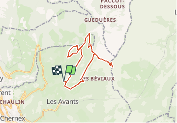
Trail Other activity of 13.3 km to be discovered at Vaud, District de la Riviera-Pays-d’Enhaut, Montreux. This trail is proposed by Romrando.
Description
Source:geocities.com/romrando - 6.8.05
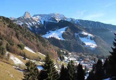
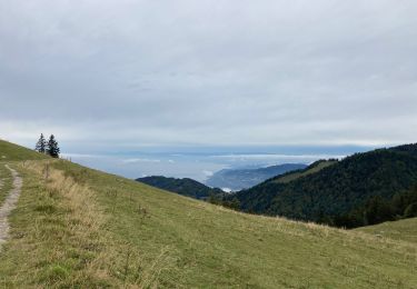
Cette randonnée offre une suite de points de vue remarquables sur toute la région.
En voiture par Blonay, Les Avants, Sonloup. Au col prendre vers le NE sur 1 km et gagner le hameau de "Cergnaule". (Parking)
Suivre sur 200 m vers l''E la route de Pleigne puis à l''épingle continuer tout droit pour remonter par un chemin carrossable tout le vallon d''Orgevaux jusqu''au Chalet détruit de "La Forcla". De là suivre horizontalement vers le SW un sentier qui contourne le Folly, ceci jusqu''à une vague arête (le chemin est tout à fait pratiquable malgré les ravages de "Lothar") où l''on rencontre les premiers arbres abattus. Suivre alors un vague sentier qui contourne par la droite les troncs couchés. L''on rejoint facilement le sommet et la crête du Folly (très beaux coup d''oeil). Par un bon chemin, on regagne "La Forcla" par l''autre versant.
De là suivre horizontalement vers le SE un bon chemin jusqu''à une vague arête que l''on suit directement vers le N jusqu''au sommet du Molard. (Très beau balcon sur toute la région).
Poursuivre par une sente vers le N et redescendre ensuite vers le chalet du "Chessy" puis directement vers une petite route carrossable. On la suit sur 100 m puis vers la gauche par un sentier on franchit une petite crête avant de descendre sur le col du Soladier.
Du col suivre par un petit sentier pratiquement le fil de l''arête vers le SE jusqu''à buter au pied de grandes parois rocheuses. Par la droite et quelques "s" puis une traversée vers le S, on rejoint le sentier du col de Jaman. Revenir vers le N pour atteindre le col de "Pierra Perchia".
De là, le chemin devient nettement plus difficile et aérien (attention au terrain gras et semelles glissantes). Une sente suit l''arête N, gazonnée, aérienne et plutôt exposée. Quelques pas faciles dans les rochers (petite chaîne pour un ressaut) permettent de gagner le sommet. La vue est très aérienne sur le bassin lémanique et toute la région.
Retour vers le Soladier par le même chemin.
Du col du Soladier vers le SW par la route puis après 150 m descendre un sentier vers le S qui rejoint une petite route carrossable que l''on suit vers le SW. A la sortie du bois elle devient goudronnée. Poursuivre cette route puis contourner la crête pour rejoindre Cergnaule.
Positioning
Comments
Trails nearby
![Trail Walking Montreux - Montreux - Villeneuve - Le Bouveret - Photo](https://media.geolcdn.com/t/375/260/ext.jpg?maxdim=2&url=https%3A%2F%2Fstatic1.geolcdn.com%2Fsiteimages%2Fupload%2Ffiles%2F1553511878bg_sport_marche.png)
![Walking Walking](https://static1.geolcdn.com/sitytour/trail-icons/101.png)
Walking
![](/images/other/stat-length.png)
![](https://static1.geolcdn.com/siteimages/upload/files/16400158638029165_repeat_loop_refresh_sync_direction_icon.png)
![Trail On foot Montreux - Sentier des Narcisses - Photo](https://media.geolcdn.com/t/375/260/9f10eb55-dea3-494b-9805-5d9bc2be0432.jpeg&format=jpg&maxdim=2)
![On foot On foot](https://static1.geolcdn.com/sitytour/trail-icons/100.png)
On foot
![](/images/other/stat-length.png)
![](https://static1.geolcdn.com/siteimages/upload/files/16400158638029165_repeat_loop_refresh_sync_direction_icon.png)
![Trail Walking Montreux - Le PACCOTA - Photo](https://media.geolcdn.com/t/375/260/ab2a8349-b8a8-4a50-b548-cf95d937a9ee.jpg&format=jpg&maxdim=2)
![Walking Walking](https://static1.geolcdn.com/sitytour/trail-icons/101.png)
Walking
![](/images/other/stat-length.png)
![](https://static1.geolcdn.com/siteimages/upload/files/16400158638029165_repeat_loop_refresh_sync_direction_icon.png)
![Trail Walking Veytaux - st_Rochers-de-Naye - Photo](https://media.geolcdn.com/t/375/260/ext.jpg?maxdim=2&url=https%3A%2F%2Fstatic1.geolcdn.com%2Fsiteimages%2Fupload%2Ffiles%2F1553511878bg_sport_marche.png)
![Walking Walking](https://static1.geolcdn.com/sitytour/trail-icons/101.png)
Walking
![](/images/other/stat-length.png)
![](https://static1.geolcdn.com/siteimages/upload/files/16400158638029165_repeat_loop_refresh_sync_direction_icon.png)
![Trail Mountain bike Blonay - Les Pléiades - Photo](https://media.geolcdn.com/t/375/260/ext.jpg?maxdim=2&url=https%3A%2F%2Fstatic1.geolcdn.com%2Fsiteimages%2Fupload%2Ffiles%2F1524743154velo.jpg)
![Mountain bike Mountain bike](https://static1.geolcdn.com/sitytour/trail-icons/202.png)
Mountain bike
![](/images/other/stat-length.png)
![](https://static1.geolcdn.com/siteimages/upload/files/16400158638029165_repeat_loop_refresh_sync_direction_icon.png)
![Trail Walking Montreux - Dent de Jaman - Rochers - de Naye - Photo](https://media.geolcdn.com/t/375/260/ext.jpg?maxdim=2&url=https%3A%2F%2Fstatic1.geolcdn.com%2Fsiteimages%2Fupload%2Ffiles%2F1553511878bg_sport_marche.png)
![Walking Walking](https://static1.geolcdn.com/sitytour/trail-icons/101.png)
Walking
![](/images/other/stat-length.png)
![](https://static1.geolcdn.com/siteimages/upload/files/16400158638029165_repeat_loop_refresh_sync_direction_icon.png)
![Trail Walking Montreux - Rando Caux Jaman Nayes - Photo](https://media.geolcdn.com/t/375/260/ext.jpg?maxdim=2&url=https%3A%2F%2Fstatic1.geolcdn.com%2Fsiteimages%2Fupload%2Ffiles%2F1553511878bg_sport_marche.png)
![Walking Walking](https://static1.geolcdn.com/sitytour/trail-icons/101.png)
Walking
![](/images/other/stat-length.png)
![](https://static1.geolcdn.com/siteimages/upload/files/16400158638029165_repeat_loop_refresh_sync_direction_icon.png)
![Trail On foot Montreux - Les Gorges du Chauderon - Photo](https://media.geolcdn.com/t/375/260/ext.jpg?maxdim=2&url=https%3A%2F%2Fstatic1.geolcdn.com%2Fsiteimages%2Fupload%2Ffiles%2F1545311037marcheuse_200dpi.jpg)
![On foot On foot](https://static1.geolcdn.com/sitytour/trail-icons/100.png)
On foot
![](/images/other/stat-length.png)
![](https://static1.geolcdn.com/siteimages/upload/files/16400158638029165_repeat_loop_refresh_sync_direction_icon.png)
![Trail On foot Montreux - Itinéraire course à pied : Boucle Hauts-de-Caux - Sonchaux - Photo](https://media.geolcdn.com/t/375/260/ext.jpg?maxdim=2&url=https%3A%2F%2Fstatic1.geolcdn.com%2Fsiteimages%2Fupload%2Ffiles%2F1545311037marcheuse_200dpi.jpg)
![On foot On foot](https://static1.geolcdn.com/sitytour/trail-icons/100.png)
On foot
![](/images/other/stat-length.png)
![](https://static1.geolcdn.com/siteimages/upload/files/16400158638029165_repeat_loop_refresh_sync_direction_icon.png)