![](/images/other/stat-length.png)
![Trail Other activity Châtel-Saint-Denis - Teysachaux (1''909 m) - Traversée - Photo](https://media.geolcdn.com/t/1900/400/ext.pjpeg?maxdim=2&url=https%3A%2F%2Fstatic1.geolcdn.com%2Fsiteimages%2Fupload%2Ffiles%2F1545311037marcheuse_200dpi.jpg)
Teysachaux (1''909 m) - Traversée
Romrando
User
![Length](/images/other/stat-length.png)
![Max alt](https://static1.geolcdn.com/siteimages/upload/files/1508320355ic_sort_altitude_max_24dp.png)
![Uphill gradient](https://static1.geolcdn.com/siteimages/upload/files/1508320355ic_sort_den_pos_24dp.png)
![Km-Effort](/images/other/stat-length.png)
![Min alt](https://static1.geolcdn.com/siteimages/upload/files/1508320355ic_sort_altitude_min_24dp.png)
![Downhill gradient](https://static1.geolcdn.com/siteimages/upload/files/1508320355ic_sort_den_neg_24dp.png)
![Boucle](https://static1.geolcdn.com/siteimages/upload/files/16400158638029165_repeat_loop_refresh_sync_direction_icon.png)
![Other activity](https://static1.geolcdn.com/sitytour/trail-icons/900.png)
--
Difficulty : Unknown
![Scan this QR Code to open this trail in the SityTrail application](https://capi.geolives.com/qq0zvz2zws4bq2lad0pu/sitytour/trails/18527/qr.png?size=200)
FREE GPS app for hiking
About
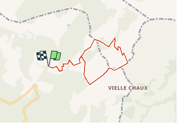
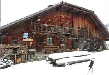
Trail Other activity of 7.4 km to be discovered at Fribourg, District de la Veveyse, Châtel-Saint-Denis. This trail is proposed by Romrando.
Description
Source:geocities.com/romrando - 6.8.05
Petite mais très belle randonnée de caractère. Point de vue splendide.
En voiture gagner les Paccots puis suivre la direction des téléskis de "Rathvel" au pied du versant E du Niremont. On peut également monter directement de Châtel par "La Frasse". Garer la voiture (petite place) environ 500 m avant les téléskis vers l''alpage de la "Pudze".
Suivre à pied une petite route goudronnée et prendre l''embranchement de droite juste après la Pudze pour remonter vers le "Chalet Incrota". Continuer vers le NE jusqu''à un petit col à l''E du chalet du "Villard" (départ variante).
Prendre une nouvelle petite route vers l''E qui s''enfonce sous le Teysachaux dans une combe un peu austère. A la deuxième épingle à cheveux on quittera celle-ci pour gagner directement au-dessus l''alpage de "Tremetta".
L''endroit est assez sauvage. Rejoindre ensuite l''arête où la vue plonge alors sur le versant E. De là le Teysachaux pourra paraître assez peu accessible à certains. Pourtant on suit le fil de l''arête d''abord horizontal pour buter au pied du sommet. Un chemin balisé très raide mais sans difficulté (mis à part le terrain très gras et toujours glissant dans cette région) vous amène directement au sommet.
Redescendre par l''arête SW (quelques ressauts faciles au début) puis rejoindre à droite l''alpage de "La Chaux". Suivre une sente 20 mètres au-dessous qui, par une descente à flanc de coteau régulière, rejoint le "Chalet Incrota". Rejoindre alors facilement la voiture.
Variante (environ 2 h de plus) :
Rejoindre le collet vers le chalet du "Villard" ci-dessus (on peut normalement s''y rendre en voiture ce qui raccourcit quelque peu le temps de marche). Descendre quelque peu puis poursuivre la route vers le NE jusqu''à rejoindre l''alpage restaurant du "Gros Plané". Remonter par le sentier vers l''E puis vers le S pour gagner une grande combe que l''on remonte jusqu''au sommet du Moléson.
De là on suit alors tout le fil de l''arête en direction du col de Tremetta. On évolue alors entre terre et ciel avec, en toile de fond, un panorama exceptionnel sur les préalpes et les alpes. Rejoindre ensuite le Teysachaux comme ci-dessus.
Positioning
Comments
Trails nearby
![Trail Snowshoes Châtel-Saint-Denis - Tour de la Cagne - Photo](https://media.geolcdn.com/t/375/260/ext.jpg?maxdim=2&url=https%3A%2F%2Fservices.sitytrail.com%2FGeolivesWS%2FDownloadMedia.ashx%3FTrailID%3D527248%26Media%3Dfix__20160218170630.jpg)
![Snowshoes Snowshoes](https://static1.geolcdn.com/sitytour/trail-icons/504.png)
Snowshoes
![](/images/other/stat-length.png)
![](https://static1.geolcdn.com/siteimages/upload/files/16400158638029165_repeat_loop_refresh_sync_direction_icon.png)
![Trail Snowshoes Châtel-Saint-Denis - Raquette 8 Le Vuipay - Photo](https://media.geolcdn.com/t/375/260/ext.jpg?maxdim=2&url=https%3A%2F%2Fservices.sitytrail.com%2FGeolivesWS%2FDownloadMedia.ashx%3FTrailID%3D1119200%26Media%3Dfix__20190306135537.jpg)
![Snowshoes Snowshoes](https://static1.geolcdn.com/sitytour/trail-icons/504.png)
Snowshoes
![](/images/other/stat-length.png)
![](https://static1.geolcdn.com/siteimages/upload/files/16400158638029165_repeat_loop_refresh_sync_direction_icon.png)
![Trail Walking Châtel-Saint-Denis - autour du Corbetta - Photo](https://media.geolcdn.com/t/375/260/ext.jpg?maxdim=2&url=https%3A%2F%2Fservices.sitytrail.com%2FGeolivesWS%2FDownloadMedia.ashx%3FTrailID%3D960115%26Media%3D20180507135802.jpg)
![Walking Walking](https://static1.geolcdn.com/sitytour/trail-icons/101.png)
Walking
![](/images/other/stat-length.png)
![](https://static1.geolcdn.com/siteimages/upload/files/16400158638029165_repeat_loop_refresh_sync_direction_icon.png)
![Trail Walking Châtel-Saint-Denis - nose - Photo](https://media.geolcdn.com/t/375/260/ext.jpg?maxdim=2&url=https%3A%2F%2Fservices.sitytrail.com%2FGeolivesWS%2FDownloadMedia.ashx%3FTrailID%3D1123242%26Media%3Dfix__20190306135537.jpg)
![Walking Walking](https://static1.geolcdn.com/sitytour/trail-icons/101.png)
Walking
![](/images/other/stat-length.png)
![](https://static1.geolcdn.com/siteimages/upload/files/16400158638029165_repeat_loop_refresh_sync_direction_icon.png)
![Trail Walking Gruyères - 2018-07-26 Plan Francey Moleson en boucle - Photo](https://media.geolcdn.com/t/375/260/ext.jpg?maxdim=2&url=https%3A%2F%2Fservices.sitytrail.com%2FGeolivesWS%2FDownloadMedia.ashx%3FTrailID%3D1011161%26Media%3Dfix__20180726124837.jpg)
![Walking Walking](https://static1.geolcdn.com/sitytour/trail-icons/101.png)
Walking
![](/images/other/stat-length.png)
![](https://static1.geolcdn.com/siteimages/upload/files/16400158638029165_repeat_loop_refresh_sync_direction_icon.png)
![Trail Snowshoes Châtel-Saint-Denis - n10 - Photo](https://media.geolcdn.com/t/375/260/ext.jpg?maxdim=2&url=https%3A%2F%2Fservices.sitytrail.com%2FGeolivesWS%2FDownloadMedia.ashx%3FTrailID%3D526815%26Media%3Dfix__20160217163833.jpg)
![Snowshoes Snowshoes](https://static1.geolcdn.com/sitytour/trail-icons/504.png)
Snowshoes
![](/images/other/stat-length.png)
![](https://static1.geolcdn.com/siteimages/upload/files/16400158638029165_repeat_loop_refresh_sync_direction_icon.png)
![Trail Other activity Gruyères - y10_gruyere - Photo](https://media.geolcdn.com/t/375/260/ext.jpg?maxdim=2&url=https%3A%2F%2Fstatic1.geolcdn.com%2Fsiteimages%2Fupload%2Ffiles%2F1545311037marcheuse_200dpi.jpg)
![Other activity Other activity](https://static1.geolcdn.com/sitytour/trail-icons/900.png)
Other activity
![](/images/other/stat-length.png)
![](https://static1.geolcdn.com/siteimages/upload/files/16400158638029165_repeat_loop_refresh_sync_direction_icon.png)
![Trail Walking Châtel-Saint-Denis - Sentiers gourmande aux Paccots - Photo](https://media.geolcdn.com/t/375/260/ext.jpg?maxdim=2&url=https%3A%2F%2Fstatic1.geolcdn.com%2Fsiteimages%2Fupload%2Ffiles%2F1553511878bg_sport_marche.png)
![Walking Walking](https://static1.geolcdn.com/sitytour/trail-icons/101.png)
Walking
![](/images/other/stat-length.png)
![](https://static1.geolcdn.com/siteimages/upload/files/16400158638029165_repeat_loop_refresh_sync_direction_icon.png)
![Trail Walking Gruyères - Käsereilehrpfad durchs Greyerzerland - Photo](https://media.geolcdn.com/t/375/260/ext.jpg?maxdim=2&url=https%3A%2F%2Fstatic1.geolcdn.com%2Fsiteimages%2Fupload%2Ffiles%2F1553511878bg_sport_marche.png)
![Walking Walking](https://static1.geolcdn.com/sitytour/trail-icons/101.png)
Walking
![](/images/other/stat-length.png)
![](https://static1.geolcdn.com/siteimages/upload/files/16400158638029165_repeat_loop_refresh_sync_direction_icon.png)