Trail Other activity Bedretto - Entre Tessin et Valais - Etape 2/4 - Photo

Entre Tessin et Valais - Etape 2/4

 Romrando
Romrando

User

© OpenStreetMap contributors
Length
Length
12.3 km
Max alt
Max alt
2695 m
Uphill gradient
Uphill gradient
846 m
Km-Effort
Km-Effort  
24 km
Min alt
Min alt
2162 m
Downhill gradient
Downhill gradient
1086 m
Boucle
Boucle
No
Creation date :
2014-12-11 00:00:00.0
Updated on :
2014-12-11 00:00:00.0

(0 Reviews)

Other activity
Other activity
--
Difficulty : Unknown

Scan this QR Code to open this trail in the SityTrail application

FREE GPS app for hiking

Logo SityTrail SityTrail

IGN / Geographical institutes

Download SityTrail from the App Store Download SityTrail from Google Play

Logo SityTrail SityTrail World

The world is yours!

Download SityTrail from the App Store Download SityTrail from Google Play Download SityTrail on Huawei AppGallery

About

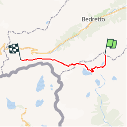
Trail Other activity of 12.3 km to be discovered at Ticino, Distretto di Leventina, Bedretto. This trail is proposed by Romrando.

Description

Source:geocities.com/romrando - 1.8.05

2ème étape

De la cabane Cristallina vers le sud longer le lac Sfundau puis vers l''W descendre pour rejoindre la route du barrage.

Par celle-ci gagner le barrage du lac de Cavagnoo, puis s''élever au-dessus de celui-ci vers le NW juqu''à une crête. On s''engage alors dans un flanc de coteau puis par une courte mais raide descendre on rejoint un grand plateau. Le chemin se poursuit alors dans un terrain morainique vers l''W avant de s''élever directement vers le col Grandinagia.

Une raide descente vous amène ensuite dans un terrain de gros blocs que l''on traverse vers l''W (peu confortable) avant de franchir une petite crête morainique. On rejoint alors facilement San Giacomo et sa chapelle.

Toujours plein ouest, par une longue traversée, on rejoint le val Corno et sa cabane de Corno Gries.

Elevation profile

Positioning

Country:
Switzerland
Region :
Ticino
Department/Province :
Distretto di Leventina
Municipality :
Bedretto
Location:
Unknown
Start:(UTM)
463628 ; 5146583 (32T) N.

Trails nearby

Trail On foot Bedretto - Alla Baita-Alpe di Cruina - Photo
On foot
GUIDE+

On foot

Easy
Bedretto, Ticino, Distretto di Leventina, Switzerland
4.8 km | 8.7 km-effort
1h 58min
No
Trail On foot Cevio - Passo Cristallina-Lielp - Photo
On foot
GUIDE+

On foot

Easy
Cevio, Ticino, Distretto di Vallemaggia, Switzerland
5.2 km | 11.9 km-effort
2h 42min
No
Trail On foot Bedretto - Alpe di Cristallina-Passo Cristallina - Photo
On foot
GUIDE+

On foot

Easy
Bedretto, Ticino, Distretto di Leventina, Switzerland
4.9 km | 7.4 km-effort
1h 41min
No
Trail Mountain bike Cevio - Wallis North 13 : Cap Basodino - Locarno - Photo
Mountain bike
ovronne

Mountain bike

Very easy
Cevio, Ticino, Distretto di Vallemaggia, Switzerland
51 km | 67 km-effort
5h 5min
No
Trail Other activity Bedretto - Wallis ins Tessin 4. Tag oder 5 A - Photo
Other activity
U106659

Other activity

Very easy
Bedretto, Ticino, Distretto di Leventina, Switzerland
15.3 km | 25 km-effort
Unknown
No
Trail Other activity Cevio - Robiei - Cavergno - Photo
Other activity
muelltho

Other activity

Very easy
Cevio, Ticino, Distretto di Vallemaggia, Switzerland
17 km | 23 km-effort
Unknown
No
Trail Walking Cevio - Robiei - Cristallina - Airolo - Photo
Walking
muelltho

Walking

Very easy
Cevio, Ticino, Distretto di Vallemaggia, Switzerland
19.9 km | 35 km-effort
6h 3min
No
Trail Other activity Bedretto - Entre Tessin et Valais - Etape 1/4 - Photo
Other activity
Romrando

Other activity

Very easy
Bedretto, Ticino, Distretto di Leventina, Switzerland
6.5 km | 19 km-effort
Unknown
No
Trail Walking Bedretto - Paso San Giacomo ch - Photo
Walking
kenleggat

Walking

Difficult
Bedretto, Ticino, Distretto di Leventina, Switzerland
13.1 km | 23 km-effort
6h 59min
Yes


Close
My subscriptions