![](/images/other/stat-length.png)
![Trail Other activity Val-de-Travers - Chasseron - Traversée (1''606 m) - Photo](https://media.geolcdn.com/t/1900/400/ext.pjpeg?maxdim=2&url=https%3A%2F%2Fstatic1.geolcdn.com%2Fsiteimages%2Fupload%2Ffiles%2F1545311037marcheuse_200dpi.jpg)
Chasseron - Traversée (1''606 m)
Romrando
User
![Length](/images/other/stat-length.png)
![Max alt](https://static1.geolcdn.com/siteimages/upload/files/1508320355ic_sort_altitude_max_24dp.png)
![Uphill gradient](https://static1.geolcdn.com/siteimages/upload/files/1508320355ic_sort_den_pos_24dp.png)
![Km-Effort](/images/other/stat-length.png)
![Min alt](https://static1.geolcdn.com/siteimages/upload/files/1508320355ic_sort_altitude_min_24dp.png)
![Downhill gradient](https://static1.geolcdn.com/siteimages/upload/files/1508320355ic_sort_den_neg_24dp.png)
![Boucle](https://static1.geolcdn.com/siteimages/upload/files/16400158638029165_repeat_loop_refresh_sync_direction_icon.png)
![Other activity](https://static1.geolcdn.com/sitytour/trail-icons/900.png)
--
Difficulty : Unknown
![Scan this QR Code to open this trail in the SityTrail application](https://capi.geolives.com/qq0zvz2zws4bq2lad0pu/sitytour/trails/18508/qr.png?size=200)
FREE GPS app for hiking
About
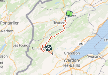
Trail Other activity of 21 km to be discovered at Neuchâtel, Unknown, Val-de-Travers. This trail is proposed by Romrando.
Description
Source:geocities.com/romrando -24.7.05
Parcours des gorges sauvages puis de crêtes jusqu''au Chasseron. Splendide !
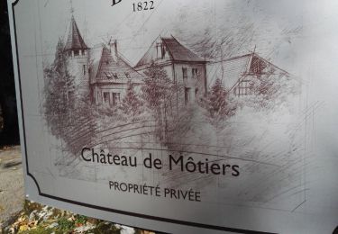
Itinéraire : Gagner Môtiers en train depuis Yverdon par Neuchâtel et le Val de Travers.
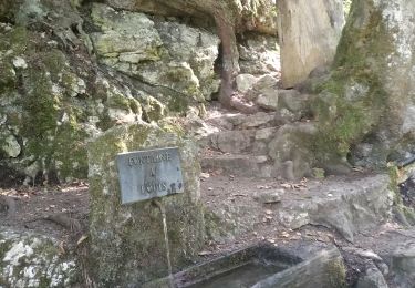
De Motiers, rejoindre le fond de la gorge que l''on remonte puis franchir différents ressauts par une succession d''escalier (très bien aménagé) et sortir par un petit défilé dans une prairie (aménagement pic-nic).
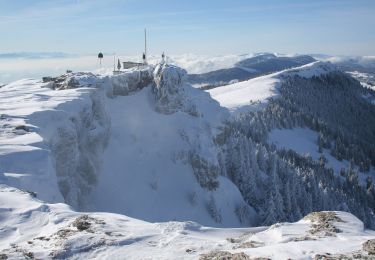
Suivre le vallon d''abord en forêt puis gagner les "Cernets" avant de rejoindre une petite route. La suivre un peu, la quitter à une épingle et rejoindre par une autre petite route la "Grandsonne-Dessus" (restauration en été). Gagner une plaine puis par la crête puis le sommet. (Hôtel-restaurant).
Du sommet poursuivre le long de la crête par les Petites Roches puis contourner le Cochet par l''est puis le sud avant de rejoindre Sainte-Croix et la gare. Poursuivre le long de la voie du train puis à gauche par les chemins on rejoint La Villette.
Par les gorges de Covatannaz on gagne Vuiteboeuf (train jusqu''à Yverdon).
Positioning
Comments
Trails nearby
![Trail On foot Val-de-Travers - Petite Robella - Hôtel du Chasseron - Photo](https://media.geolcdn.com/t/375/260/0bf4a378-a248-44d3-808c-d2ab1b2031e3.jpeg&format=jpg&maxdim=2)
![On foot On foot](https://static1.geolcdn.com/sitytour/trail-icons/100.png)
On foot
![](/images/other/stat-length.png)
![](https://static1.geolcdn.com/siteimages/upload/files/16400158638029165_repeat_loop_refresh_sync_direction_icon.png)
![Trail On foot Provence - Les Rochats-La Baronne - Photo](https://media.geolcdn.com/t/375/260/eb114c23-ff66-494e-8e4f-6d744e522ff4.jpeg&format=jpg&maxdim=2)
![On foot On foot](https://static1.geolcdn.com/sitytour/trail-icons/100.png)
On foot
![](/images/other/stat-length.png)
![](https://static1.geolcdn.com/siteimages/upload/files/16400158638029165_repeat_loop_refresh_sync_direction_icon.png)
![Trail On foot Val-de-Travers - Ferme du Soliat - La Banderette - Photo](https://media.geolcdn.com/t/375/260/592b5f1a-c4f5-43de-8e09-4f7fd6995df5.jpeg&format=jpg&maxdim=2)
![On foot On foot](https://static1.geolcdn.com/sitytour/trail-icons/100.png)
On foot
![](/images/other/stat-length.png)
![](https://static1.geolcdn.com/siteimages/upload/files/16400158638029165_repeat_loop_refresh_sync_direction_icon.png)
![Trail On foot Val-de-Travers - Pouetta Raisse-Môtiers - Photo](https://media.geolcdn.com/t/375/260/dev_7178d45b-3807-4ad5-a6c4-160045aad4be.jpeg&format=jpg&maxdim=2)
![On foot On foot](https://static1.geolcdn.com/sitytour/trail-icons/100.png)
On foot
![](/images/other/stat-length.png)
![](https://static1.geolcdn.com/siteimages/upload/files/16400158638029165_repeat_loop_refresh_sync_direction_icon.png)
![Trail Walking Val-de-Travers - Môtiert Gorges de la Poetta Raisse Le Chasseron 17 sept 2020 CAF - Photo](https://media.geolcdn.com/t/375/260/622f7812-5563-496b-8727-813df172fc9a.jpg&format=jpg&maxdim=2)
![Walking Walking](https://static1.geolcdn.com/sitytour/trail-icons/101.png)
Walking
![](/images/other/stat-length.png)
![](https://static1.geolcdn.com/siteimages/upload/files/16400158638029165_repeat_loop_refresh_sync_direction_icon.png)
![Trail Walking Val-de-Travers - Môtiers - gorges de Pouetta Raisse circuit 16.10.17 - Photo](https://media.geolcdn.com/t/375/260/ext.jpg?maxdim=2&url=https%3A%2F%2Fservices.sitytrail.com%2FGeolivesWS%2FDownloadMedia.ashx%3FTrailID%3D847333%26Media%3D56d94813-d5c2-4320-b75e-59bea3163cf8.jpg)
![Walking Walking](https://static1.geolcdn.com/sitytour/trail-icons/101.png)
Walking
![](/images/other/stat-length.png)
![](https://static1.geolcdn.com/siteimages/upload/files/16400158638029165_repeat_loop_refresh_sync_direction_icon.png)
![Trail On foot Tévenon - La Combaz-Les Rochats - Photo](https://media.geolcdn.com/t/375/260/ext.jpg?maxdim=2&url=https%3A%2F%2Fstatic1.geolcdn.com%2Fsiteimages%2Fupload%2Ffiles%2F1545311037marcheuse_200dpi.jpg)
![On foot On foot](https://static1.geolcdn.com/sitytour/trail-icons/100.png)
On foot
![](/images/other/stat-length.png)
![](https://static1.geolcdn.com/siteimages/upload/files/16400158638029165_repeat_loop_refresh_sync_direction_icon.png)
![Trail On foot Provence - Les Rochats-Le Couvent - Photo](https://media.geolcdn.com/t/375/260/ext.jpg?maxdim=2&url=https%3A%2F%2Fstatic1.geolcdn.com%2Fsiteimages%2Fupload%2Ffiles%2F1545311037marcheuse_200dpi.jpg)
![On foot On foot](https://static1.geolcdn.com/sitytour/trail-icons/100.png)
On foot
![](/images/other/stat-length.png)
![](https://static1.geolcdn.com/siteimages/upload/files/16400158638029165_repeat_loop_refresh_sync_direction_icon.png)