![](/images/other/stat-length.png)
![Trail Other activity Gersau - Rigi-Hochflue - Photo](https://media.geolcdn.com/t/1900/400/ext.pjpeg?maxdim=2&url=https%3A%2F%2Fstatic1.geolcdn.com%2Fsiteimages%2Fupload%2Ffiles%2F1545311037marcheuse_200dpi.jpg)
Rigi-Hochflue
Pfenniger
User
![Length](/images/other/stat-length.png)
Length
5.2 km
![Max alt](https://static1.geolcdn.com/siteimages/upload/files/1508320355ic_sort_altitude_max_24dp.png)
Max alt
1715 m
![Uphill gradient](https://static1.geolcdn.com/siteimages/upload/files/1508320355ic_sort_den_pos_24dp.png)
Uphill gradient
573 m
![Km-Effort](/images/other/stat-length.png)
Km-Effort
12.9 km
![Min alt](https://static1.geolcdn.com/siteimages/upload/files/1508320355ic_sort_altitude_min_24dp.png)
Min alt
1139 m
![Downhill gradient](https://static1.geolcdn.com/siteimages/upload/files/1508320355ic_sort_den_neg_24dp.png)
Downhill gradient
586 m
![Boucle](https://static1.geolcdn.com/siteimages/upload/files/16400158638029165_repeat_loop_refresh_sync_direction_icon.png)
Boucle
Yes
Creation date :
2014-12-11 00:00:00.0
Updated on :
2014-12-11 00:00:00.0
![Other activity](https://static1.geolcdn.com/sitytour/trail-icons/900.png)
--
Difficulty : Unknown
![Scan this QR Code to open this trail in the SityTrail application](https://capi.geolives.com/qq0zvz2zws4bq2lad0pu/sitytour/trails/18447/qr.png?size=200)
FREE GPS app for hiking
About
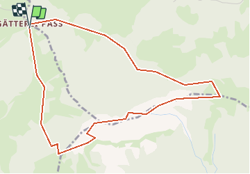
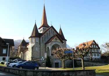
Trail Other activity of 5.2 km to be discovered at Schwyz, Gersau, Gersau. This trail is proposed by Pfenniger.
Description
Vom Gätterlipass über Scharteggli,Chälewald,Südflanke zum Gipfel.
Abstieg über Ostgrat,Nordflanke,Spitz,Egg,Bsetzibann,Rohrboden zurück zum Gätterlipass.
Positioning
Country:
Switzerland
Region :
Schwyz
Department/Province :
Gersau
Municipality :
Gersau
Location:
Unknown
Start:(Dec)
Start:(UTM)
465894 ; 5207279 (32T) N.
Comments
Trails nearby
![Trail On foot Arth - Rigi Kulm - Dächli - Photo](https://media.geolcdn.com/t/375/260/3c2cb0ab-5605-4529-8e72-77b21225ace2.jpeg&format=jpg&maxdim=2)
![On foot On foot](https://static1.geolcdn.com/sitytour/trail-icons/100.png)
![Trail On foot Arth - Hinder Dossen - Rigi Klösterli - Photo](https://media.geolcdn.com/t/375/260/3727fee8-a543-4af1-8e32-f04c5bf3c90a.jpeg&format=jpg&maxdim=2)
![On foot On foot](https://static1.geolcdn.com/sitytour/trail-icons/100.png)
Hinder Dossen - Rigi Klösterli
On foot
Easy
Arth,
Schwyz,
Schwyz,
Switzerland
![](/images/other/stat-length.png)
4.1 km | 6.8 km-effort
1h 32min
![](https://static1.geolcdn.com/siteimages/upload/files/16400158638029165_repeat_loop_refresh_sync_direction_icon.png)
No
![Trail On foot Arth - Goldau-Dächli - Photo](https://media.geolcdn.com/t/375/260/dev_a4792a56-aed8-4c53-a0a6-82e5ae078d7c.jpeg&format=jpg&maxdim=2)
![On foot On foot](https://static1.geolcdn.com/sitytour/trail-icons/100.png)
![Trail On foot Arth - Parkplatz A4 - Ochsenchneu - Photo](https://media.geolcdn.com/t/375/260/b696f0f2-2153-4a62-8662-61950384350f.jpeg&format=jpg&maxdim=2)
![On foot On foot](https://static1.geolcdn.com/sitytour/trail-icons/100.png)
Parkplatz A4 - Ochsenchneu
On foot
Easy
Arth,
Schwyz,
Schwyz,
Switzerland
![](/images/other/stat-length.png)
3.1 km | 7 km-effort
1h 35min
![](https://static1.geolcdn.com/siteimages/upload/files/16400158638029165_repeat_loop_refresh_sync_direction_icon.png)
No
![Trail Mountain bike Ingenbohl - Mythen - Photo](https://media.geolcdn.com/t/375/260/ext.jpg?maxdim=2&url=https%3A%2F%2Fstatic1.geolcdn.com%2Fsiteimages%2Fupload%2Ffiles%2F1524743154velo.jpg)
![Mountain bike Mountain bike](https://static1.geolcdn.com/sitytour/trail-icons/202.png)
Mythen
Mountain bike
Very easy
Ingenbohl,
Schwyz,
Schwyz,
Switzerland
![](/images/other/stat-length.png)
37 km | 57 km-effort
13h 26min
![](https://static1.geolcdn.com/siteimages/upload/files/16400158638029165_repeat_loop_refresh_sync_direction_icon.png)
Yes
![Trail Mountain bike Arth - Rigi - Photo](https://media.geolcdn.com/t/375/260/ext.jpg?maxdim=2&url=https%3A%2F%2Fstatic1.geolcdn.com%2Fsiteimages%2Fupload%2Ffiles%2F1524743154velo.jpg)
![Mountain bike Mountain bike](https://static1.geolcdn.com/sitytour/trail-icons/202.png)
![Trail Walking Ingenbohl - sf09_e5d - Photo](https://media.geolcdn.com/t/375/260/ext.jpg?maxdim=2&url=https%3A%2F%2Fstatic1.geolcdn.com%2Fsiteimages%2Fupload%2Ffiles%2F1553511878bg_sport_marche.png)
![Walking Walking](https://static1.geolcdn.com/sitytour/trail-icons/101.png)
sf09_e5d
Walking
Very easy
Ingenbohl,
Schwyz,
Schwyz,
Switzerland
![](/images/other/stat-length.png)
15.1 km | 26 km-effort
4h 40min
![](https://static1.geolcdn.com/siteimages/upload/files/16400158638029165_repeat_loop_refresh_sync_direction_icon.png)
No
![Trail Walking Gersau - sf09_e5c - Photo](https://media.geolcdn.com/t/375/260/ext.jpg?maxdim=2&url=https%3A%2F%2Fstatic1.geolcdn.com%2Fsiteimages%2Fupload%2Ffiles%2F1553511878bg_sport_marche.png)
![Walking Walking](https://static1.geolcdn.com/sitytour/trail-icons/101.png)
![Trail Walking Gersau - Rigi - Panorama - Photo](https://media.geolcdn.com/t/375/260/ext.jpg?maxdim=2&url=https%3A%2F%2Fstatic1.geolcdn.com%2Fsiteimages%2Fupload%2Ffiles%2F1553511878bg_sport_marche.png)
![Walking Walking](https://static1.geolcdn.com/sitytour/trail-icons/101.png)
Rigi - Panorama
Walking
Medium
Gersau,
Schwyz,
Gersau,
Switzerland
![](/images/other/stat-length.png)
9.3 km | 14.9 km-effort
3h 15min
![](https://static1.geolcdn.com/siteimages/upload/files/16400158638029165_repeat_loop_refresh_sync_direction_icon.png)
No