Trail Walking Realp - YHH036 Realp - Göscheneralp (2e jour) - Photo

YHH036 Realp - Göscheneralp (2e jour)

© OpenStreetMap contributors
Length
Length
12.2 km
Max alt
Max alt
2821 m
Uphill gradient
Uphill gradient
1032 m
Km-Effort
Km-Effort  
27 km
Min alt
Min alt
1806 m
Downhill gradient
Downhill gradient
1239 m
Boucle
Boucle
No
Creation date :
2015-04-15 00:00:00.0
Updated on :
2015-04-15 00:00:00.0

(0 Reviews)

Walking
Walking
8h20
Difficulty : Very difficult

Scan this QR Code to open this trail in the SityTrail application

FREE GPS app for hiking

Logo SityTrail SityTrail

IGN / Geographical institutes

Download SityTrail from the App Store Download SityTrail from Google Play

Logo SityTrail SityTrail World

The world is yours!

Download SityTrail from the App Store Download SityTrail from Google Play Download SityTrail on Huawei AppGallery

About

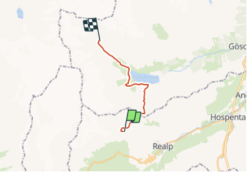
Trail Walking of 12.2 km to be discovered at Uri, Korporation Ursern, Realp. This trail is proposed by yveshumbert.

Description

Cette deuxième étape est beaucoup plus sportive que  la première.
L?itinéraire est classé T4  par le CAS. Nous l?avons fait en 9h00 (incluant quelques courtes pauses pour manger et boire).
On commence par redescendre sur le sentier d?accès à Realp. Le chemin tourne alors à gauche (P. 2381) et commence à monter. Il n?y pas de difficultés majeures pour vous rendre au col de Lochberglücke (P.2815). La descente est plus rude. Au début il n?y a pas de chemin, il faut suivre le balisage et les cairns, qui slaloment entre les rochers. Depuis l? Alpergensee (P.2511), le chemin est un peu plus facile. Vous arriverez au P.1927 avec une jolie vue sur le Göscheneralpsee. Depuis là le chemin est beaucoup plus facile. Vous suivrez la rive droite du lac par un chemin un peu vallonné pour finalement traverser sur un pont le Dammareuss (P.1967). En continuant vous arriverez au bout du lac (P.1813) et vous remontez le Chelenreuss par la rive gauche. Pour vous rendre à la cabane Chelenalphütte, il vous faudra fournir encore un petit effort, car la dernière partie du chemin monte bien

Elevation profile

Positioning

Country:
Switzerland
Region :
Uri
Department/Province :
Korporation Ursern
Municipality :
Realp
Location:
Unknown
Start:(UTM)
458931 ; 5161823 (32T) N.

Trails nearby

Trail On foot Göschenen - Göscheneralp - Horwen - Photo
On foot
PRO

On foot

Easy
Göschenen, Uri, Unknown, Switzerland
4.5 km | 6.2 km-effort
1h 23min
No
Trail On foot Göschenen - Göscheneralpsee Rundwanderung - Photo
On foot
PRO

On foot

Easy
Göschenen, Uri, Unknown, Switzerland
8.8 km | 14.4 km-effort
3h 16min
Yes
Trail On foot Göschenen - Göscheneralp-Bergsee - Photo
On foot
PRO

On foot

Easy
Göschenen, Uri, Unknown, Switzerland
3.5 km | 9.3 km-effort
2h 6min
No
Trail Walking Göschenen - Göscheneralp Tal - Photo
Walking
GUIDE+

Walking

Very easy
Göschenen, Uri, Unknown, Switzerland
18.3 km | 29 km-effort
Unknown
No
Trail Walking Realp - sf_e8c - Photo
Walking
GUIDE+

Walking

Very easy
Realp, Uri, Korporation Ursern, Switzerland
23 km | 39 km-effort
6h 52min
No
Trail Walking Realp - sf_e8b - Photo
Walking
GUIDE+

Walking

Very easy
Realp, Uri, Korporation Ursern, Switzerland
11.2 km | 21 km-effort
3h 36min
Yes
Trail Walking Göschenen - sf_e7b - Photo
Walking
GUIDE+

Walking

Very easy
Göschenen, Uri, Unknown, Switzerland
12.6 km | 22 km-effort
3h 50min
No
Trail Walking Realp - Realp - Tiefenbach 2012  - Photo
Walking
micol

Walking

Very easy
Realp, Uri, Korporation Ursern, Switzerland
5.3 km | 11.4 km-effort
3h 6min
No
Trail Other activity Göschenen - Chelenalp - Photo
Other activity
alternatives-wandern

Other activity

Very easy
Göschenen, Uri, Unknown, Switzerland
13.6 km | 29 km-effort
Unknown
Yes


Close
My subscriptions