![](/images/other/stat-length.png)
![Trail Winter sports Pontresina - YHH026 Pontresina à Roseg - Photo](https://media.geolcdn.com/t/1900/400/ext.pjpeg?maxdim=2&url=https%3A%2F%2Fstatic1.geolcdn.com%2Fsiteimages%2Fupload%2Ffiles%2F1524743153ski.jpg)
YHH026 Pontresina à Roseg
yveshumbert
User
![Length](/images/other/stat-length.png)
![Max alt](https://static1.geolcdn.com/siteimages/upload/files/1508320355ic_sort_altitude_max_24dp.png)
![Uphill gradient](https://static1.geolcdn.com/siteimages/upload/files/1508320355ic_sort_den_pos_24dp.png)
![Km-Effort](/images/other/stat-length.png)
![Min alt](https://static1.geolcdn.com/siteimages/upload/files/1508320355ic_sort_altitude_min_24dp.png)
![Downhill gradient](https://static1.geolcdn.com/siteimages/upload/files/1508320355ic_sort_den_neg_24dp.png)
![Boucle](https://static1.geolcdn.com/siteimages/upload/files/16400158638029165_repeat_loop_refresh_sync_direction_icon.png)
![Winter sports](https://static1.geolcdn.com/sitytour/trail-icons/500.png)
3h00
Difficulty : Difficult
![Scan this QR Code to open this trail in the SityTrail application](https://capi.geolives.com/qq0zvz2zws4bq2lad0pu/sitytour/trails/18385/qr.png?size=200)
FREE GPS app for hiking
About
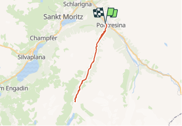
Trail Winter sports of 19 km to be discovered at Grisons, Maloja, Pontresina. This trail is proposed by yveshumbert.
Description
Ballade à ski de fond (seulement en traditionnel) sur les pistes balisées
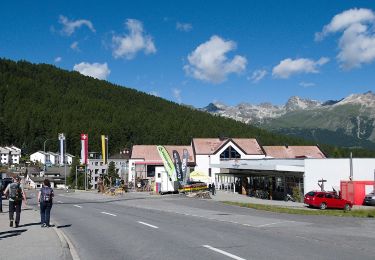
Départ de la gare de Pontresina. Avec cet itinéraire on remonte tout le val Roseg.
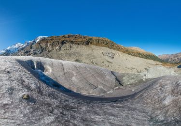
La montée est régulière et pas trop difficile. Une fois arrivé au restaurant du Roseg (restauration possible), la vue est beaucoup plus dégagée. Vous pouvez pratiquement continuer jusqu?à la fin du vallon. Le retour se fait par le même itinéraire.
Positioning
Comments
Trails nearby
![Trail On foot Sankt Moritz - SEERUNDGANG - Photo](https://media.geolcdn.com/t/375/260/fb476387-3b2e-4236-b860-c8f411416028.jpeg&format=jpg&maxdim=2)
![On foot On foot](https://static1.geolcdn.com/sitytour/trail-icons/100.png)
On foot
![](/images/other/stat-length.png)
![](https://static1.geolcdn.com/siteimages/upload/files/16400158638029165_repeat_loop_refresh_sync_direction_icon.png)
![Trail On foot Pontresina - Muottas Muragl - Unterer Schafberg - Photo](https://media.geolcdn.com/t/375/260/fdb48e21-1399-4e12-aef6-21c111ae9825.jpeg&format=jpg&maxdim=2)
![On foot On foot](https://static1.geolcdn.com/sitytour/trail-icons/100.png)
On foot
![](/images/other/stat-length.png)
![](https://static1.geolcdn.com/siteimages/upload/files/16400158638029165_repeat_loop_refresh_sync_direction_icon.png)
![Trail On foot Samedan - Muottas Muragl - Chna. Segantini - Photo](https://media.geolcdn.com/t/375/260/d84cc500-2aaa-4cb6-8029-493b05a6f4f0.jpeg&format=jpg&maxdim=2)
![On foot On foot](https://static1.geolcdn.com/sitytour/trail-icons/100.png)
On foot
![](/images/other/stat-length.png)
![](https://static1.geolcdn.com/siteimages/upload/files/16400158638029165_repeat_loop_refresh_sync_direction_icon.png)
![Trail On foot Pontresina - Puntraschigna - Roseg - Photo](https://media.geolcdn.com/t/375/260/228522e8-b30d-4ac8-8507-135e9cf1526f.jpeg&format=jpg&maxdim=2)
![On foot On foot](https://static1.geolcdn.com/sitytour/trail-icons/100.png)
On foot
![](/images/other/stat-length.png)
![](https://static1.geolcdn.com/siteimages/upload/files/16400158638029165_repeat_loop_refresh_sync_direction_icon.png)
![Trail On foot Pontresina - Morteratsch-Pontresina - Photo](https://media.geolcdn.com/t/375/260/94324081-6d23-45ff-8174-b20d5cceabc3.jpeg&format=jpg&maxdim=2)
![On foot On foot](https://static1.geolcdn.com/sitytour/trail-icons/100.png)
On foot
![](/images/other/stat-length.png)
![](https://static1.geolcdn.com/siteimages/upload/files/16400158638029165_repeat_loop_refresh_sync_direction_icon.png)
![Trail On foot Pontresina - Morteratsch-chamanna da Boval - Photo](https://media.geolcdn.com/t/375/260/c22691e5-109a-463b-9df6-1a1d7b81abf6.jpeg&format=jpg&maxdim=2)
![On foot On foot](https://static1.geolcdn.com/sitytour/trail-icons/100.png)
On foot
![](/images/other/stat-length.png)
![](https://static1.geolcdn.com/siteimages/upload/files/16400158638029165_repeat_loop_refresh_sync_direction_icon.png)
![Trail sport Pontresina - 2024 02 21 - Photo](https://media.geolcdn.com/t/375/260/ed0f1d78-ef2c-464c-8c70-b0956e5ece8b.jpg&format=jpg&maxdim=2)
sport
![](/images/other/stat-length.png)
![](https://static1.geolcdn.com/siteimages/upload/files/16400158638029165_repeat_loop_refresh_sync_direction_icon.png)
![Trail Other activity Pontresina - y10_muottas_muragl - Photo](https://media.geolcdn.com/t/375/260/ext.jpg?maxdim=2&url=https%3A%2F%2Fstatic1.geolcdn.com%2Fsiteimages%2Fupload%2Ffiles%2F1545311037marcheuse_200dpi.jpg)
![Other activity Other activity](https://static1.geolcdn.com/sitytour/trail-icons/900.png)
Other activity
![](/images/other/stat-length.png)
![](https://static1.geolcdn.com/siteimages/upload/files/16400158638029165_repeat_loop_refresh_sync_direction_icon.png)
![Trail Walking Sankt Moritz - mtb04 - Photo](https://media.geolcdn.com/t/375/260/ext.jpg?maxdim=2&url=https%3A%2F%2Fstatic1.geolcdn.com%2Fsiteimages%2Fupload%2Ffiles%2F1553511878bg_sport_marche.png)
![Walking Walking](https://static1.geolcdn.com/sitytour/trail-icons/101.png)