Trail Snowshoes Bex - YHH008 Anxeindaz- Plan du Sex - Photo

YHH008 Anxeindaz- Plan du Sex

© OpenStreetMap contributors
Length
Length
6.2 km
Max alt
Max alt
2098 m
Uphill gradient
Uphill gradient
308 m
Km-Effort
Km-Effort  
10.3 km
Min alt
Min alt
1890 m
Downhill gradient
Downhill gradient
304 m
Boucle
Boucle
Yes
Creation date :
2014-12-11 00:00:00.0
Updated on :
2014-12-11 00:00:00.0

(0 Reviews)

Snowshoes
Snowshoes
2h00
Difficulty : Unknown

Scan this QR Code to open this trail in the SityTrail application

FREE GPS app for hiking

Logo SityTrail SityTrail

IGN / Geographical institutes

Download SityTrail from the App Store Download SityTrail from Google Play

Logo SityTrail SityTrail World

The world is yours!

Download SityTrail from the App Store Download SityTrail from Google Play Download SityTrail on Huawei AppGallery

About

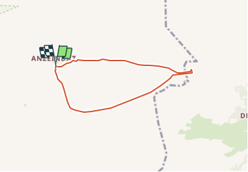
Trail Snowshoes of 6.2 km to be discovered at Vaud, District d'Aigle, Bex. This trail is proposed by yveshumbert.

Description

C’est un joli petit tour de 2 heures avec peu de dénivelé. Depuis le refuge Giacomini on commence à monter en direction de la cabane Barraud et ensuite on contourne dans le sens contraire des aiguilles d’une montre le Roc de la Vache. On monte pour atteindre le plateau pour finalement redescendre sur le Plan de Sex. Le retour se fait en ligne droite pratiquement à plat par le Pas de Cheville.

Elevation profile

Positioning

Country:
Switzerland
Region :
Vaud
Department/Province :
District d'Aigle
Municipality :
Bex
Location:
Unknown
Start:(UTM)
358402 ; 5127691 (32T) N.

Trails nearby

Trail Walking Bex - Tour du miroir d'Argentine - Photo
Walking
perenhout

Walking

Very difficult
Bex, Vaud, District d'Aigle, Switzerland
16.8 km | 30 km-effort
7h 5min
Yes
Trail Walking Bex - Bex (Genferseegebiet) - Photo
Walking
GUIDE+

Walking

Very easy
Bex, Vaud, District d'Aigle, Switzerland
10.5 km | 18.6 km-effort
5h 55min
Yes
Trail Walking Conthey - huetten_02 - Photo
Walking
GUIDE+

Walking

Very easy
Conthey, Valais/Wallis, Conthey, Switzerland
50 km | 102 km-effort
16h 52min
Yes
Trail Walking Ormont-Dessus - w10_24_diable - Photo
Walking
GUIDE+

Walking

Very easy
Ormont-Dessus, Vaud, District d'Aigle, Switzerland
12.9 km | 17.3 km-effort
3h 38min
No
Trail Walking Ollon - Circuit Col de la Croix - les lacs - Bretaye 13.07.17 - Photo
Walking
duamerg

Walking

Medium
Ollon, Vaud, District d'Aigle, Switzerland
13.8 km | 21 km-effort
4h 27min
Yes
Trail Walking Conthey - Lac Forcla - Photo
Walking
jipi2

Walking

Medium
Conthey, Valais/Wallis, Conthey, Switzerland
16.8 km | 33 km-effort
8h 1min
Yes
Trail Walking Ollon - Col de la Croix - Photo
Walking
danihz

Walking

Medium
Ollon, Vaud, District d'Aigle, Switzerland
11.9 km | 18.1 km-effort
3h 51min
Yes
Trail Walking Conthey - Martigny-Kandersteg (3) Hotel du Sanetsch - Photo
Walking
rpf

Walking

Very easy
Conthey, Valais/Wallis, Conthey, Switzerland
14.8 km | 28 km-effort
6h 45min
No
Trail Walking Conthey - Derborence, Pas de Cheville - Photo
Walking
rpf

Walking

Very easy
Conthey, Valais/Wallis, Conthey, Switzerland
8.8 km | 18.1 km-effort
5h 30min
Yes


Close
My subscriptions