Trail Walking Rousset - La Viste - Vières - Photo
 jlv05
jlv05

User

© OpenStreetMap contributors
Length
Length
17.3 km
Max alt
Max alt
1434 m
Uphill gradient
Uphill gradient
846 m
Km-Effort
Km-Effort  
29 km
Min alt
Min alt
692 m
Downhill gradient
Downhill gradient
847 m
Boucle
Boucle
Yes
Creation date :
2014-12-10 00:00:00.0
Updated on :
2014-12-10 00:00:00.0

(1 Reviews)

Walking
Walking
5h00
Difficulty : Medium

Scan this QR Code to open this trail in the SityTrail application

FREE GPS app for hiking

Logo SityTrail SityTrail

IGN / Geographical institutes

Download SityTrail from the App Store Download SityTrail from Google Play

Logo SityTrail SityTrail World

The world is yours!

Download SityTrail from the App Store Download SityTrail from Google Play Download SityTrail on Huawei AppGallery

About

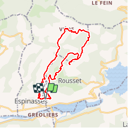
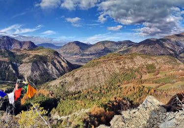
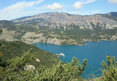
Trail Walking of 17.3 km to be discovered at Provence-Alpes-Côte d'Azur, Hautes-Alpes, Rousset. This trail is proposed by jlv05.

Elevation profile

Positioning

Country:
France
Region :
Provence-Alpes-Côte d'Azur
Department/Province :
Hautes-Alpes
Municipality :
Rousset
Location:
Unknown
Start:(UTM)
279845 ; 4927667 (32T) N.

Comments

Please log in to post a review or rate the element


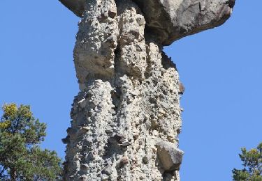
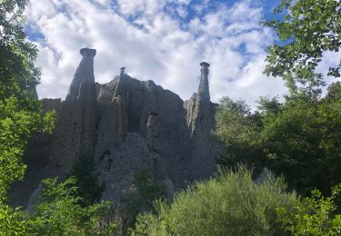
fait le 30 nov 2017 a partir du col de laus , avons pris la première montée très raide .la haut et les crêtes super beau.merci .gilou440


Trails nearby

Trail Walking Théus - R47   Les Demoiselles Coiffees - Photo
Walking
GUIDE+

Walking

Very easy
(2)
Théus, Provence-Alpes-Côte d'Azur, Hautes-Alpes, France
6.7 km | 13.4 km-effort
2h 31min
Yes
Trail Walking Théus - Les demoiselles coiffées  - Photo
Walking
Fabichette

Walking

Difficult
(1)
Théus, Provence-Alpes-Côte d'Azur, Hautes-Alpes, France
7.5 km | 14.2 km-effort
3h 13min
Yes
Trail Walking Ubaye-Serre-Ponçon - Circuit de l'Escoubaye 25 -12- 2014 - Photo
Walking
Dervalmarc

Walking

Easy
(1)
Ubaye-Serre-Ponçon, Provence-Alpes-Côte d'Azur, Alpes-de-Haute-Provence, France
6.9 km | 10.1 km-effort
2h 32min
Yes
Trail Walking Chorges - clôt c l'avais sur fein - Photo
Walking
Didier.kiehl

Walking

Very easy
(2)
Chorges, Provence-Alpes-Côte d'Azur, Hautes-Alpes, France
8 km | 12.6 km-effort
2h 24min
Yes
Trail Walking Rochebrune - Chapelle Saint-Sixte Via Rochebrune - Photo
Walking
PapouBertrand

Walking

Medium
(1)
Rochebrune, Provence-Alpes-Côte d'Azur, Hautes-Alpes, France
3.9 km | 7.4 km-effort
1h 52min
Yes
Trail Walking Ubaye-Serre-Ponçon - L'Escoubaye - Photo
Walking
FERAUD

Walking

Medium
(1)
Ubaye-Serre-Ponçon, Provence-Alpes-Côte d'Azur, Alpes-de-Haute-Provence, France
6 km | 9 km-effort
1h 22min
Yes
Trail Walking Ubaye-Serre-Ponçon - L'Escoubaye - Photo
Walking
saintherant

Walking

Easy
(1)
Ubaye-Serre-Ponçon, Provence-Alpes-Côte d'Azur, Alpes-de-Haute-Provence, France
4.5 km | 7.4 km-effort
2h 0min
Yes
Trail Walking Ubaye-Serre-Ponçon - Circuit de Costebelle - Photo
Walking
saintherant

Walking

Medium
(2)
Ubaye-Serre-Ponçon, Provence-Alpes-Côte d'Azur, Alpes-de-Haute-Provence, France
8.2 km | 12.8 km-effort
2h 30min
Yes
Trail Walking Chorges - Clôt Clavary 3.9.23 - Photo
Walking
GUIDE
fredetpascale

Walking

Easy
Chorges, Provence-Alpes-Côte d'Azur, Hautes-Alpes, France
7.1 km | 11.6 km-effort
2h 0min
Yes


Close
My subscriptions