![](/images/other/stat-length.png)
![Trail Mountain bike Le Crotoy - Chemin des Bergers - Photo](https://media.geolcdn.com/t/1900/400/ext.pjpeg?maxdim=2&url=https%3A%2F%2Fstatic1.geolcdn.com%2Fsiteimages%2Fupload%2Ffiles%2F1524743154velo.jpg)
Chemin des Bergers
© OpenStreetMap contributors
![Mountain bike](https://static1.geolcdn.com/sitytour/trail-icons/202.png)
Mountain bike
1h11
Difficulty : Medium
![Length](/images/other/stat-length.png)
Length
16.6 km
![Max alt](https://static1.geolcdn.com/siteimages/upload/files/1508320355ic_sort_altitude_max_24dp.png)
Max alt
12 m
![Uphill gradient](https://static1.geolcdn.com/siteimages/upload/files/1508320355ic_sort_den_pos_24dp.png)
Uphill gradient
57 m
![Km-Effort](/images/other/stat-length.png)
Km-Effort
17.4 km
![Min alt](https://static1.geolcdn.com/siteimages/upload/files/1508320355ic_sort_altitude_min_24dp.png)
Min alt
2 m
![Downhill gradient](https://static1.geolcdn.com/siteimages/upload/files/1508320355ic_sort_den_neg_24dp.png)
Downhill gradient
58 m
![Boucle](https://static1.geolcdn.com/siteimages/upload/files/16400158638029165_repeat_loop_refresh_sync_direction_icon.png)
Boucle
Yes
Creation date :
2014-12-10 00:00:00.0
Updated on :
2014-12-10 00:00:00.0
![Mountain bike](https://static1.geolcdn.com/sitytour/trail-icons/202.png)
1h11
Difficulty : Medium
![Scan this QR Code to open this trail in the SityTrail application](https://capi.geolives.com/qq0zvz2zws4bq2lad0pu/sitytour/trails/183082/qr.png?size=200)
FREE GPS app for hiking
About
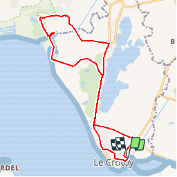
Trail Mountain bike of 16.6 km to be discovered at Hauts-de-France, Somme, Le Crotoy. This trail is proposed by jacques.moulin@hotmail.com.
Description
Au départ du Crotoy, on rejoint la rue des Mouettes jusqu'à l'entrée de St Firmin. Au centre Nautique, on prend à gauche la rue de la Maye jusqu'à la baie. Parcours du combattant jusqu'au pont sur la Maye. On longe alors le Parc du Marquenterre par le sentier des bergers. Retour par l'enclave du Champ Neuf, l'écluse de Férolles. ATTENTION : dans le sable : à pied....
Positioning
Country:
France
Region :
Hauts-de-France
Department/Province :
Somme
Municipality :
Le Crotoy
Location:
Unknown
Start:(Dec)
Start:(UTM)
402355 ; 5563720 (31U) N.
Comments
Trails nearby
![Trail Walking Saint-Valery-sur-Somme - Balade à Saint-Valéry-sur-Somme - Photo](https://media.geolcdn.com/t/375/260/ext.jpg?maxdim=2&url=https%3A%2F%2Fservices.sitytrail.com%2FGeolivesWS%2FDownloadMedia.ashx%3FTrailID%3D438142%26Media%3Dfed88654-3b60-4043-bb2e-e5c8c6773117.JPG)
![Walking Walking](https://static1.geolcdn.com/sitytour/trail-icons/101.png)
Balade à Saint-Valéry-sur-Somme
Walking
Easy
(4)
Saint-Valery-sur-Somme,
Hauts-de-France,
Somme,
France
![](/images/other/stat-length.png)
10.4 km | 12.2 km-effort
2h 41min
![](https://static1.geolcdn.com/siteimages/upload/files/16400158638029165_repeat_loop_refresh_sync_direction_icon.png)
Yes
![Trail Walking Le Crotoy - CDT80-3 - Photo](https://media.geolcdn.com/t/375/260/cef91e86-689f-4bd7-8591-33e387b29cb5.jpg&format=jpg&maxdim=2)
![Walking Walking](https://static1.geolcdn.com/sitytour/trail-icons/101.png)
CDT80-3
Walking
Medium
(2)
Le Crotoy,
Hauts-de-France,
Somme,
France
![](/images/other/stat-length.png)
6 km | 6.1 km-effort
1h 23min
![](https://static1.geolcdn.com/siteimages/upload/files/16400158638029165_repeat_loop_refresh_sync_direction_icon.png)
Yes
![Trail Walking Cayeux-sur-Mer - Le Hourdel V2 - Photo](https://media.geolcdn.com/t/375/260/ext.jpg?maxdim=2&url=https%3A%2F%2Fservices.sitytrail.com%2FGeolivesWS%2FDownloadMedia.ashx%3FTrailID%3D108609%26Media%3D1517_1.jpg)
![Walking Walking](https://static1.geolcdn.com/sitytour/trail-icons/101.png)
Le Hourdel V2
Walking
Difficult
(1)
Cayeux-sur-Mer,
Hauts-de-France,
Somme,
France
![](/images/other/stat-length.png)
8 km | 8.4 km-effort
2h 30min
![](https://static1.geolcdn.com/siteimages/upload/files/16400158638029165_repeat_loop_refresh_sync_direction_icon.png)
Yes
![Trail Walking Saint-Valery-sur-Somme - Balade à Saint-Valery sur Somme - Photo](https://media.geolcdn.com/t/375/260/ext.jpg?maxdim=2&url=https%3A%2F%2Fservices.sitytrail.com%2FGeolivesWS%2FDownloadMedia.ashx%3FTrailID%3D108607%26Media%3D1515_1.jpg)
![Walking Walking](https://static1.geolcdn.com/sitytour/trail-icons/101.png)
Balade à Saint-Valery sur Somme
Walking
Medium
(3)
Saint-Valery-sur-Somme,
Hauts-de-France,
Somme,
France
![](/images/other/stat-length.png)
7.1 km | 8.6 km-effort
2h 19min
![](https://static1.geolcdn.com/siteimages/upload/files/16400158638029165_repeat_loop_refresh_sync_direction_icon.png)
Yes
![Trail Walking Favières - Circuit de Morlay - Photo](https://media.geolcdn.com/t/375/260/ext.jpg?maxdim=2&url=https%3A%2F%2Fservices.sitytrail.com%2FGeolivesWS%2FDownloadMedia.ashx%3FTrailID%3D108602%26Media%3D1510_1.jpg)
![Walking Walking](https://static1.geolcdn.com/sitytour/trail-icons/101.png)
Circuit de Morlay
Walking
Difficult
(1)
Favières,
Hauts-de-France,
Somme,
France
![](/images/other/stat-length.png)
12.4 km | 12.8 km-effort
4h 0min
![](https://static1.geolcdn.com/siteimages/upload/files/16400158638029165_repeat_loop_refresh_sync_direction_icon.png)
Yes
![Trail Walking Saint-Valery-sur-Somme - Traversée Baie de Somme 11/08/2021 - Photo](https://media.geolcdn.com/t/375/260/486a482e-6345-45f3-b041-b66bc4ab348e.jpg&format=jpg&maxdim=2)
![Walking Walking](https://static1.geolcdn.com/sitytour/trail-icons/101.png)
Traversée Baie de Somme 11/08/2021
Walking
Medium
Saint-Valery-sur-Somme,
Hauts-de-France,
Somme,
France
![](/images/other/stat-length.png)
8.5 km | 8.8 km-effort
2h 0min
![](https://static1.geolcdn.com/siteimages/upload/files/16400158638029165_repeat_loop_refresh_sync_direction_icon.png)
No
![Trail Walking Saint-Valery-sur-Somme - w-frankrijk-over-dijken-en-kwelders - Photo](https://media.geolcdn.com/t/375/260/ext.jpg?maxdim=2&url=https%3A%2F%2Fstatic1.geolcdn.com%2Fsiteimages%2Fupload%2Ffiles%2F1553511878bg_sport_marche.png)
![Walking Walking](https://static1.geolcdn.com/sitytour/trail-icons/101.png)
w-frankrijk-over-dijken-en-kwelders
Walking
Very easy
(2)
Saint-Valery-sur-Somme,
Hauts-de-France,
Somme,
France
![](/images/other/stat-length.png)
13.8 km | 14.9 km-effort
Unknown
![](https://static1.geolcdn.com/siteimages/upload/files/16400158638029165_repeat_loop_refresh_sync_direction_icon.png)
Yes
![Trail Mountain bike Saint-Valery-sur-Somme - Gravelot Baie de sommes - Photo](https://media.geolcdn.com/t/375/260/ext.jpg?maxdim=2&url=https%3A%2F%2Fstatic1.geolcdn.com%2Fsiteimages%2Fupload%2Ffiles%2F1524743154velo.jpg)
![Mountain bike Mountain bike](https://static1.geolcdn.com/sitytour/trail-icons/202.png)
Gravelot Baie de sommes
Mountain bike
Easy
(1)
Saint-Valery-sur-Somme,
Hauts-de-France,
Somme,
France
![](/images/other/stat-length.png)
44 km | 47 km-effort
4h 56min
![](https://static1.geolcdn.com/siteimages/upload/files/16400158638029165_repeat_loop_refresh_sync_direction_icon.png)
Yes
![Trail Equestrian Le Crotoy - de la Maye vers marquenterre - Photo](https://media.geolcdn.com/t/375/260/ext.jpg?maxdim=2&url=https%3A%2F%2Fstatic1.geolcdn.com%2Fsiteimages%2Fupload%2Ffiles%2F1524743154cheval.jpg)
![Equestrian Equestrian](https://static1.geolcdn.com/sitytour/trail-icons/300.png)
de la Maye vers marquenterre
Equestrian
Very easy
(4)
Le Crotoy,
Hauts-de-France,
Somme,
France
![](/images/other/stat-length.png)
20 km | 21 km-effort
2h 43min
![](https://static1.geolcdn.com/siteimages/upload/files/16400158638029165_repeat_loop_refresh_sync_direction_icon.png)
No