![](/images/other/stat-length.png)
![Trail Other activity Andermatt - SCA-00-Sentier culturel des Alpes - Est - Photo](https://media.geolcdn.com/t/1900/400/ext.pjpeg?maxdim=2&url=https%3A%2F%2Fstatic1.geolcdn.com%2Fsiteimages%2Fupload%2Ffiles%2F1545311037marcheuse_200dpi.jpg)
SCA-00-Sentier culturel des Alpes - Est
Dgubler
User
![Length](/images/other/stat-length.png)
Length
214 km
![Max alt](https://static1.geolcdn.com/siteimages/upload/files/1508320355ic_sort_altitude_max_24dp.png)
Max alt
2764 m
![Uphill gradient](https://static1.geolcdn.com/siteimages/upload/files/1508320355ic_sort_den_pos_24dp.png)
Uphill gradient
21709 m
![Km-Effort](/images/other/stat-length.png)
Km-Effort
504 km
![Min alt](https://static1.geolcdn.com/siteimages/upload/files/1508320355ic_sort_altitude_min_24dp.png)
Min alt
560 m
![Downhill gradient](https://static1.geolcdn.com/siteimages/upload/files/1508320355ic_sort_den_neg_24dp.png)
Downhill gradient
21969 m
![Boucle](https://static1.geolcdn.com/siteimages/upload/files/16400158638029165_repeat_loop_refresh_sync_direction_icon.png)
Boucle
No
Creation date :
2014-12-11 00:00:00.0
Updated on :
2014-12-11 00:00:00.0
![Other activity](https://static1.geolcdn.com/sitytour/trail-icons/900.png)
--
Difficulty : Unknown
![Scan this QR Code to open this trail in the SityTrail application](https://capi.geolives.com/qq0zvz2zws4bq2lad0pu/sitytour/trails/18123/qr.png?size=200)
FREE GPS app for hiking
About
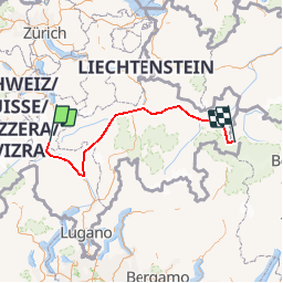
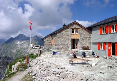
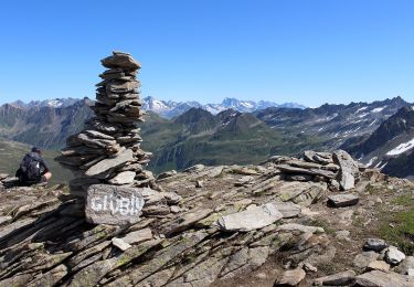
Trail Other activity of 214 km to be discovered at Uri, Korporation Ursern, Andermatt. This trail is proposed by Dgubler.
Description
Le Sentier culturel des Alpes (une initiative des Amis de la Nature, www.amisdelanature.ch), moitié orientale, d''Andermatt à Müstair.
The Eastern half of the Swiss Alps Cultural Trail, from Andermatt to Müstair.
Positioning
Country:
Switzerland
Region :
Uri
Department/Province :
Korporation Ursern
Municipality :
Andermatt
Location:
Unknown
Start:(Dec)
Start:(UTM)
469298 ; 5164430 (32T) N.
Comments
Trails nearby
![Trail On foot Andermatt - Kräuterlehrpfad Mur - Photo](https://media.geolcdn.com/t/375/260/23ebdf3d-6550-42a3-bdcb-791aa1e419ea.jpeg&format=jpg&maxdim=2)
![On foot On foot](https://static1.geolcdn.com/sitytour/trail-icons/100.png)
Kräuterlehrpfad Mur
On foot
Easy
Andermatt,
Uri,
Korporation Ursern,
Switzerland
![](/images/other/stat-length.png)
7.6 km | 10.5 km-effort
2h 23min
![](https://static1.geolcdn.com/siteimages/upload/files/16400158638029165_repeat_loop_refresh_sync_direction_icon.png)
No
![Trail On foot Andermatt - Blumen- und Lawinenlehrpfad Chilchenberg - Photo](https://media.geolcdn.com/t/375/260/23ebdf3d-6550-42a3-bdcb-791aa1e419ea.jpeg&format=jpg&maxdim=2)
![On foot On foot](https://static1.geolcdn.com/sitytour/trail-icons/100.png)
Blumen- und Lawinenlehrpfad Chilchenberg
On foot
Easy
Andermatt,
Uri,
Korporation Ursern,
Switzerland
![](/images/other/stat-length.png)
3.9 km | 8.4 km-effort
1h 54min
![](https://static1.geolcdn.com/siteimages/upload/files/16400158638029165_repeat_loop_refresh_sync_direction_icon.png)
No
![Trail On foot Andermatt - Schöni - Pazolalücke - Photo](https://media.geolcdn.com/t/375/260/d1617093-8655-46c4-9467-a0f549651cea.jpeg&format=jpg&maxdim=2)
![On foot On foot](https://static1.geolcdn.com/sitytour/trail-icons/100.png)
Schöni - Pazolalücke
On foot
Easy
Andermatt,
Uri,
Korporation Ursern,
Switzerland
![](/images/other/stat-length.png)
3.7 km | 10.3 km-effort
2h 20min
![](https://static1.geolcdn.com/siteimages/upload/files/16400158638029165_repeat_loop_refresh_sync_direction_icon.png)
No
![Trail On foot Andermatt - Stöckli - Steglaui Riental - Photo](https://media.geolcdn.com/t/375/260/18a6a89b-b2db-4bc5-bdbd-b09a3baf89d4.jpeg&format=jpg&maxdim=2)
![On foot On foot](https://static1.geolcdn.com/sitytour/trail-icons/100.png)
Stöckli - Steglaui Riental
On foot
Easy
Andermatt,
Uri,
Korporation Ursern,
Switzerland
![](/images/other/stat-length.png)
6.7 km | 11.2 km-effort
2h 33min
![](https://static1.geolcdn.com/siteimages/upload/files/16400158638029165_repeat_loop_refresh_sync_direction_icon.png)
No
![Trail On foot Andermatt - Golfrundweg - Photo](https://media.geolcdn.com/t/375/260/89334e40-d25e-499c-90c6-7d30e1b20946.jpeg&format=jpg&maxdim=2)
![On foot On foot](https://static1.geolcdn.com/sitytour/trail-icons/100.png)
Golfrundweg
On foot
Easy
Andermatt,
Uri,
Korporation Ursern,
Switzerland
![](/images/other/stat-length.png)
5.6 km | 7.2 km-effort
1h 38min
![](https://static1.geolcdn.com/siteimages/upload/files/16400158638029165_repeat_loop_refresh_sync_direction_icon.png)
Yes
![Trail On foot Andermatt - Vermigel - Capanna Cadlimo - Photo](https://media.geolcdn.com/t/375/260/55e4726d-a963-4121-9825-2227d492a520.jpeg&format=jpg&maxdim=2)
![On foot On foot](https://static1.geolcdn.com/sitytour/trail-icons/100.png)
Vermigel - Capanna Cadlimo
On foot
Easy
Andermatt,
Uri,
Korporation Ursern,
Switzerland
![](/images/other/stat-length.png)
7.4 km | 17.6 km-effort
4h 0min
![](https://static1.geolcdn.com/siteimages/upload/files/16400158638029165_repeat_loop_refresh_sync_direction_icon.png)
No
![Trail On foot Andermatt - Lago della Sella - Sunnsbühl - Photo](https://media.geolcdn.com/t/375/260/8dfbce18-3c5b-4b83-9802-71ce5e04d009.jpeg&format=jpg&maxdim=2)
![On foot On foot](https://static1.geolcdn.com/sitytour/trail-icons/100.png)
Lago della Sella - Sunnsbühl
On foot
Easy
Andermatt,
Uri,
Korporation Ursern,
Switzerland
![](/images/other/stat-length.png)
5 km | 12.4 km-effort
2h 48min
![](https://static1.geolcdn.com/siteimages/upload/files/16400158638029165_repeat_loop_refresh_sync_direction_icon.png)
No
![Trail On foot Andermatt - Ursener Höhenweg - Photo](https://media.geolcdn.com/t/375/260/f7b36a6e-ed2a-4f4f-9e56-9c6f30267693.jpeg&format=jpg&maxdim=2)
![On foot On foot](https://static1.geolcdn.com/sitytour/trail-icons/100.png)
Ursener Höhenweg
On foot
Medium
Andermatt,
Uri,
Korporation Ursern,
Switzerland
![](/images/other/stat-length.png)
13.9 km | 26 km-effort
5h 49min
![](https://static1.geolcdn.com/siteimages/upload/files/16400158638029165_repeat_loop_refresh_sync_direction_icon.png)
No
![Trail On foot Andermatt - Andermatt - Vermigel - Photo](https://media.geolcdn.com/t/375/260/ext.jpg?maxdim=2&url=https%3A%2F%2Fstatic1.geolcdn.com%2Fsiteimages%2Fupload%2Ffiles%2F1545311037marcheuse_200dpi.jpg)
![On foot On foot](https://static1.geolcdn.com/sitytour/trail-icons/100.png)
Andermatt - Vermigel
On foot
Easy
Andermatt,
Uri,
Korporation Ursern,
Switzerland
![](/images/other/stat-length.png)
5.5 km | 10.1 km-effort
2h 17min
![](https://static1.geolcdn.com/siteimages/upload/files/16400158638029165_repeat_loop_refresh_sync_direction_icon.png)
No