![](/images/other/stat-length.png)
![Trail Mountain bike Herbeumont - herbeumont vers St Cécile - Photo](https://media.geolcdn.com/t/1900/400/ext.pjpeg?maxdim=2&url=https%3A%2F%2Fstatic1.geolcdn.com%2Fsiteimages%2Fupload%2Ffiles%2F1524743154velo.jpg)
herbeumont vers St Cécile
pascaldaiche
User
![Length](/images/other/stat-length.png)
Length
20 km
![Max alt](https://static1.geolcdn.com/siteimages/upload/files/1508320355ic_sort_altitude_max_24dp.png)
Max alt
443 m
![Uphill gradient](https://static1.geolcdn.com/siteimages/upload/files/1508320355ic_sort_den_pos_24dp.png)
Uphill gradient
475 m
![Km-Effort](/images/other/stat-length.png)
Km-Effort
27 km
![Min alt](https://static1.geolcdn.com/siteimages/upload/files/1508320355ic_sort_altitude_min_24dp.png)
Min alt
264 m
![Downhill gradient](https://static1.geolcdn.com/siteimages/upload/files/1508320355ic_sort_den_neg_24dp.png)
Downhill gradient
475 m
![Boucle](https://static1.geolcdn.com/siteimages/upload/files/16400158638029165_repeat_loop_refresh_sync_direction_icon.png)
Boucle
Yes
Creation date :
2014-12-10 00:00:00.0
Updated on :
2014-12-10 00:00:00.0
![Mountain bike](https://static1.geolcdn.com/sitytour/trail-icons/202.png)
1h44
Difficulty : Medium
![Scan this QR Code to open this trail in the SityTrail application](https://capi.geolives.com/qq0zvz2zws4bq2lad0pu/sitytour/trails/179276/qr.png?size=200)
FREE GPS app for hiking
About
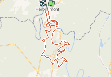
Trail Mountain bike of 20 km to be discovered at Wallonia, Luxembourg, Herbeumont. This trail is proposed by pascaldaiche.
Description
Traversée du viaduc ,points de vue magnifiques sur la semois,vanne des moines,les étangs de conques,vanne de conques,20km de bonheur !
Positioning
Country:
Belgium
Region :
Wallonia
Department/Province :
Luxembourg
Municipality :
Herbeumont
Location:
Herbeumont
Start:(Dec)
Start:(UTM)
661096 ; 5516654 (31U) N.
Comments
Trails nearby
![Trail Other activity Bertrix - BX08 - Photo](https://media.geolcdn.com/t/375/260/ext.jpg?maxdim=2&url=https%3A%2F%2Fstatic1.geolcdn.com%2Fsiteimages%2Fupload%2Ffiles%2F1545311037marcheuse_200dpi.jpg)
![Other activity Other activity](https://static1.geolcdn.com/sitytour/trail-icons/900.png)
BX08
Other activity
Very easy
(9)
Bertrix,
Wallonia,
Luxembourg,
Belgium
![](/images/other/stat-length.png)
7.3 km | 10 km-effort
2h 30min
![](https://static1.geolcdn.com/siteimages/upload/files/16400158638029165_repeat_loop_refresh_sync_direction_icon.png)
Yes
![Walking Walking](https://static1.geolcdn.com/sitytour/trail-icons/101.png)
RB-Lu-23_Herbeumont_via-racc-1-et-var
Walking
Very difficult
(4)
Herbeumont,
Wallonia,
Luxembourg,
Belgium
![](/images/other/stat-length.png)
18.6 km | 25 km-effort
5h 44min
![](https://static1.geolcdn.com/siteimages/upload/files/16400158638029165_repeat_loop_refresh_sync_direction_icon.png)
Yes
![Walking Walking](https://static1.geolcdn.com/sitytour/trail-icons/101.png)
RB-Lu-23_Herbeumont
Walking
Difficult
(2)
Herbeumont,
Wallonia,
Luxembourg,
Belgium
![](/images/other/stat-length.png)
26 km | 35 km-effort
7h 26min
![](https://static1.geolcdn.com/siteimages/upload/files/16400158638029165_repeat_loop_refresh_sync_direction_icon.png)
Yes
![Walking Walking](https://static1.geolcdn.com/sitytour/trail-icons/101.png)
Marche Adeps 10 km
Walking
Difficult
(6)
Herbeumont,
Wallonia,
Luxembourg,
Belgium
![](/images/other/stat-length.png)
9.1 km | 12.6 km-effort
2h 51min
![](https://static1.geolcdn.com/siteimages/upload/files/16400158638029165_repeat_loop_refresh_sync_direction_icon.png)
Yes
![Trail Walking Florenville - rando les epioux 15/09/2020 - Photo](https://media.geolcdn.com/t/375/260/f418135f-9d94-414f-b063-7d7f558c9ced.jpg&format=jpg&maxdim=2)
![Walking Walking](https://static1.geolcdn.com/sitytour/trail-icons/101.png)
rando les epioux 15/09/2020
Walking
Very easy
(1)
Florenville,
Wallonia,
Luxembourg,
Belgium
![](/images/other/stat-length.png)
18.1 km | 23 km-effort
4h 7min
![](https://static1.geolcdn.com/siteimages/upload/files/16400158638029165_repeat_loop_refresh_sync_direction_icon.png)
Yes
![Trail Walking Florenville - 14km St Cécile vers Herbeumont - Photo](https://media.geolcdn.com/t/375/260/ext.jpg?maxdim=2&url=https%3A%2F%2Fservices.sitytrail.com%2FGeolivesWS%2FDownloadMedia.ashx%3FTrailID%3D1023598%26Media%3Dfix__20180817123348.jpg)
![Walking Walking](https://static1.geolcdn.com/sitytour/trail-icons/101.png)
14km St Cécile vers Herbeumont
Walking
Medium
(1)
Florenville,
Wallonia,
Luxembourg,
Belgium
![](/images/other/stat-length.png)
14 km | 18.1 km-effort
2h 56min
![](https://static1.geolcdn.com/siteimages/upload/files/16400158638029165_repeat_loop_refresh_sync_direction_icon.png)
Yes
![Trail Walking Herbeumont - RSIH - Herbeumont - Les Épioux - Photo](https://media.geolcdn.com/t/375/260/ca0e741e-0f45-4c3d-9414-5f2e5834b9ce.jpg&format=jpg&maxdim=2)
![Walking Walking](https://static1.geolcdn.com/sitytour/trail-icons/101.png)
RSIH - Herbeumont - Les Épioux
Walking
Difficult
(1)
Herbeumont,
Wallonia,
Luxembourg,
Belgium
![](/images/other/stat-length.png)
14.8 km | 19.2 km-effort
4h 21min
![](https://static1.geolcdn.com/siteimages/upload/files/16400158638029165_repeat_loop_refresh_sync_direction_icon.png)
Yes
![Trail Walking Herbeumont - Les Burzais - départ du gite Le bout des bois - Photo](https://media.geolcdn.com/t/375/260/ext.jpg?maxdim=2&url=https%3A%2F%2Fservices.sitytrail.com%2FGeolivesWS%2FDownloadMedia.ashx%3FTrailID%3D419104%26Media%3Dfix__20140609121902.jpg)
![Walking Walking](https://static1.geolcdn.com/sitytour/trail-icons/101.png)
Les Burzais - départ du gite Le bout des bois
Walking
Medium
(3)
Herbeumont,
Wallonia,
Luxembourg,
Belgium
![](/images/other/stat-length.png)
4.2 km | 5.9 km-effort
1h 30min
![](https://static1.geolcdn.com/siteimages/upload/files/16400158638029165_repeat_loop_refresh_sync_direction_icon.png)
Yes
![Trail Running Herbeumont - herbeumont libaipire - Photo](https://media.geolcdn.com/t/375/260/ext.jpg?maxdim=2&url=https%3A%2F%2Fservices.sitytrail.com%2FGeolivesWS%2FDownloadMedia.ashx%3FTrailID%3D356345%26Media%3Dfix__20141022103733.jpg)
![Running Running](https://static1.geolcdn.com/sitytour/trail-icons/103.png)
herbeumont libaipire
Running
Medium
(1)
Herbeumont,
Wallonia,
Luxembourg,
Belgium
![](/images/other/stat-length.png)
15.5 km | 22 km-effort
1h 46min
![](https://static1.geolcdn.com/siteimages/upload/files/16400158638029165_repeat_loop_refresh_sync_direction_icon.png)
No