![](/images/other/stat-length.png)
![Trail Walking Montanay - A_MONTANAY 69270 Grange Durand - Fontaine Camille - Photo](https://media.geolcdn.com/t/1900/400/ext.pjpeg?maxdim=2&url=https%3A%2F%2Fstatic1.geolcdn.com%2Fsiteimages%2Fupload%2Ffiles%2F1553511878bg_sport_marche.png)
A_MONTANAY 69270 Grange Durand - Fontaine Camille
ANDREJAC
User
![Length](/images/other/stat-length.png)
Length
10.4 km
![Max alt](https://static1.geolcdn.com/siteimages/upload/files/1508320355ic_sort_altitude_max_24dp.png)
Max alt
310 m
![Uphill gradient](https://static1.geolcdn.com/siteimages/upload/files/1508320355ic_sort_den_pos_24dp.png)
Uphill gradient
182 m
![Km-Effort](/images/other/stat-length.png)
Km-Effort
12.8 km
![Min alt](https://static1.geolcdn.com/siteimages/upload/files/1508320355ic_sort_altitude_min_24dp.png)
Min alt
188 m
![Downhill gradient](https://static1.geolcdn.com/siteimages/upload/files/1508320355ic_sort_den_neg_24dp.png)
Downhill gradient
183 m
![Boucle](https://static1.geolcdn.com/siteimages/upload/files/16400158638029165_repeat_loop_refresh_sync_direction_icon.png)
Boucle
Yes
Creation date :
2014-12-10 00:00:00.0
Updated on :
2014-12-10 00:00:00.0
![Walking](https://static1.geolcdn.com/sitytour/trail-icons/101.png)
3h00
Difficulty : Easy
![Scan this QR Code to open this trail in the SityTrail application](https://capi.geolives.com/qq0zvz2zws4bq2lad0pu/sitytour/trails/178744/qr.png?size=200)
FREE GPS app for hiking
About
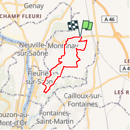
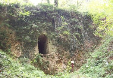
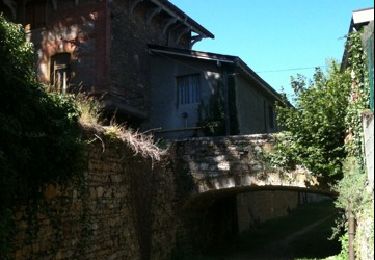
Trail Walking of 10.4 km to be discovered at Auvergne-Rhône-Alpes, Métropole de Lyon, Montanay. This trail is proposed by ANDREJAC.
Description
Départ Complexe Sportif ; Grange Durand, Le Bourg, Le Villard, La Verchère, Jabouret, Réservoir, Champ Blanc, La Grande Charrière, La Fontaine Guibaud, Les Fromenteaux, retour Complexe Sportif.
Positioning
Country:
France
Region :
Auvergne-Rhône-Alpes
Department/Province :
Métropole de Lyon
Municipality :
Montanay
Location:
Unknown
Start:(Dec)
Start:(UTM)
645274 ; 5082656 (31T) N.
Comments
Trails nearby
![Trail Walking Couzon-au-Mont-d'Or - Tour de Couzon par les crêtes - Photo](https://media.geolcdn.com/t/375/260/ext.jpg?maxdim=2&url=https%3A%2F%2Fservices.sitytrail.com%2FGeolivesWS%2FDownloadMedia.ashx%3FTrailID%3D626228%26Media%3D20160904183041.jpg)
![Walking Walking](https://static1.geolcdn.com/sitytour/trail-icons/101.png)
Tour de Couzon par les crêtes
Walking
Difficult
(2)
Couzon-au-Mont-d'Or,
Auvergne-Rhône-Alpes,
Métropole de Lyon,
France
![](/images/other/stat-length.png)
6.5 km | 10.7 km-effort
2h 5min
![](https://static1.geolcdn.com/siteimages/upload/files/16400158638029165_repeat_loop_refresh_sync_direction_icon.png)
Yes
![Trail Walking Couzon-au-Mont-d'Or - A_COUZON AU MT D'OR 69270 Croix Vitaise - Mont Thoux - Photo](https://media.geolcdn.com/t/375/260/ext.jpg?maxdim=2&url=https%3A%2F%2Fstatic1.geolcdn.com%2Fsiteimages%2Fupload%2Ffiles%2F1553511878bg_sport_marche.png)
![Walking Walking](https://static1.geolcdn.com/sitytour/trail-icons/101.png)
A_COUZON AU MT D'OR 69270 Croix Vitaise - Mont Thoux
Walking
Medium
(2)
Couzon-au-Mont-d'Or,
Auvergne-Rhône-Alpes,
Métropole de Lyon,
France
![](/images/other/stat-length.png)
8.5 km | 13.6 km-effort
3h 0min
![](https://static1.geolcdn.com/siteimages/upload/files/16400158638029165_repeat_loop_refresh_sync_direction_icon.png)
Yes
![Trail Mountain bike Fontaines-sur-Saône - Rando de la Madone de Fleurieu sur Saône - Photo](https://media.geolcdn.com/t/375/260/ext.jpg?maxdim=2&url=https%3A%2F%2Fstatic1.geolcdn.com%2Fsiteimages%2Fupload%2Ffiles%2F1524743154velo.jpg)
![Mountain bike Mountain bike](https://static1.geolcdn.com/sitytour/trail-icons/202.png)
Rando de la Madone de Fleurieu sur Saône
Mountain bike
Medium
(1)
Fontaines-sur-Saône,
Auvergne-Rhône-Alpes,
Métropole de Lyon,
France
![](/images/other/stat-length.png)
24 km | 30 km-effort
2h 30min
![](https://static1.geolcdn.com/siteimages/upload/files/16400158638029165_repeat_loop_refresh_sync_direction_icon.png)
Yes
![Trail Walking Civrieux - Et si ca mord pas... Civrieux en Dombres - Photo](https://media.geolcdn.com/t/375/260/ext.jpg?maxdim=2&url=https%3A%2F%2Fstatic1.geolcdn.com%2Fsiteimages%2Fupload%2Ffiles%2F1553511878bg_sport_marche.png)
![Walking Walking](https://static1.geolcdn.com/sitytour/trail-icons/101.png)
Et si ca mord pas... Civrieux en Dombres
Walking
Easy
(1)
Civrieux,
Auvergne-Rhône-Alpes,
Ain,
France
![](/images/other/stat-length.png)
3.4 km | 4 km-effort
1h 30min
![](https://static1.geolcdn.com/siteimages/upload/files/16400158638029165_repeat_loop_refresh_sync_direction_icon.png)
Yes
![Trail Walking Couzon-au-Mont-d'Or - Couzon au Mont d’Or - Photo](https://media.geolcdn.com/t/375/260/ffb75b1e-3c23-4b27-9cc0-36458a9af4a3.jpg&format=jpg&maxdim=2)
![Walking Walking](https://static1.geolcdn.com/sitytour/trail-icons/101.png)
Couzon au Mont d’Or
Walking
Medium
Couzon-au-Mont-d'Or,
Auvergne-Rhône-Alpes,
Métropole de Lyon,
France
![](/images/other/stat-length.png)
10.7 km | 15.9 km-effort
3h 26min
![](https://static1.geolcdn.com/siteimages/upload/files/16400158638029165_repeat_loop_refresh_sync_direction_icon.png)
Yes
![Trail Walking Couzon-au-Mont-d'Or - Cousin au Montd'Or - Photo](https://media.geolcdn.com/t/375/260/337e495a-7504-4516-acf9-9553d219a322.jpg&format=jpg&maxdim=2)
![Walking Walking](https://static1.geolcdn.com/sitytour/trail-icons/101.png)
Cousin au Montd'Or
Walking
Easy
Couzon-au-Mont-d'Or,
Auvergne-Rhône-Alpes,
Métropole de Lyon,
France
![](/images/other/stat-length.png)
10.7 km | 15.8 km-effort
4h 15min
![](https://static1.geolcdn.com/siteimages/upload/files/16400158638029165_repeat_loop_refresh_sync_direction_icon.png)
Yes
![Trail Horseback riding Couzon-au-Mont-d'Or - 15 km croix rampau Curis-au-Mont-d’Or - Photo](https://media.geolcdn.com/t/375/260/3baeeb7b-fc8f-45ee-a97e-6988c52c408f.jpg&format=jpg&maxdim=2)
![Horseback riding Horseback riding](https://static1.geolcdn.com/sitytour/trail-icons/301.png)
15 km croix rampau Curis-au-Mont-d’Or
Horseback riding
Medium
Couzon-au-Mont-d'Or,
Auvergne-Rhône-Alpes,
Métropole de Lyon,
France
![](/images/other/stat-length.png)
15.5 km | 23 km-effort
3h 11min
![](https://static1.geolcdn.com/siteimages/upload/files/16400158638029165_repeat_loop_refresh_sync_direction_icon.png)
Yes
![Trail Walking Montanay - Le Val de Saône - Montanay - Photo](https://media.geolcdn.com/t/375/260/ext.jpg?maxdim=2&url=https%3A%2F%2Fservices.sitytrail.com%2FGeolivesWS%2FDownloadMedia.ashx%3FTrailID%3D103989%26Media%3D6901_3.jpg)
![Walking Walking](https://static1.geolcdn.com/sitytour/trail-icons/101.png)
Le Val de Saône - Montanay
Walking
Medium
Montanay,
Auvergne-Rhône-Alpes,
Métropole de Lyon,
France
![](/images/other/stat-length.png)
9.2 km | 11.1 km-effort
2h 0min
![](https://static1.geolcdn.com/siteimages/upload/files/16400158638029165_repeat_loop_refresh_sync_direction_icon.png)
Yes
![Trail Walking Saint-Romain-au-Mont-d'Or - Saint Romain hauteurs 2010-07-18 - Photo](https://media.geolcdn.com/t/375/260/ext.jpg?maxdim=2&url=https%3A%2F%2Fservices.sitytrail.com%2FGeolivesWS%2FDownloadMedia.ashx%3FTrailID%3D41470%26Media%3Dimage10.jpg)
![Walking Walking](https://static1.geolcdn.com/sitytour/trail-icons/101.png)
Saint Romain hauteurs 2010-07-18
Walking
Very easy
Saint-Romain-au-Mont-d'Or,
Auvergne-Rhône-Alpes,
Métropole de Lyon,
France
![](/images/other/stat-length.png)
4.8 km | 8.1 km-effort
1h 30min
![](https://static1.geolcdn.com/siteimages/upload/files/16400158638029165_repeat_loop_refresh_sync_direction_icon.png)
Yes