Trail Walking Ensigné - Ensigné - Photo
 olaze
olaze

User

© OpenStreetMap contributors
Length
Length
11.1 km
Max alt
Max alt
102 m
Uphill gradient
Uphill gradient
75 m
Km-Effort
Km-Effort  
12.1 km
Min alt
Min alt
62 m
Downhill gradient
Downhill gradient
77 m
Boucle
Boucle
Yes
Creation date :
2014-12-10 00:00:00.0
Updated on :
2014-12-10 00:00:00.0

(0 Reviews)

Walking
Walking
2h42
Difficulty : Easy

Scan this QR Code to open this trail in the SityTrail application

FREE GPS app for hiking

Logo SityTrail SityTrail

IGN / Geographical institutes

Download SityTrail from the App Store Download SityTrail from Google Play

Logo SityTrail SityTrail World

The world is yours!

Download SityTrail from the App Store Download SityTrail from Google Play Download SityTrail on Huawei AppGallery

About

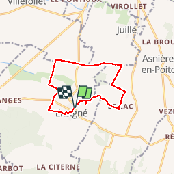
Trail Walking of 11.1 km to be discovered at New Aquitaine, Deux-Sèvres, Ensigné. This trail is proposed by olaze.

Description

Agréable promenade dans la campagne.
Départ & retour d'Ensigné.
Club rando ATSCAF 79 03/13
         

Elevation profile

Photos

Positioning

Country:
France
Region :
New Aquitaine
Department/Province :
Deux-Sèvres
Municipality :
Ensigné
Location:
Unknown
Start:(UTM)
713221 ; 5107553 (30T) N.

Trails nearby

Trail Walking Villiers-sur-Chizé - Camino 2 04-2-2019 - Photo
Walking
bene_dictus77

Walking

Medium
Villiers-sur-Chizé, New Aquitaine, Deux-Sèvres, France
12.3 km | 13.8 km-effort
2h 52min
No


Close
My subscriptions