![](/images/other/stat-length.png)
![Trail Walking Sulniac - Le sentier du Lavoir (Jaune) 3.3 kms - Photo](https://media.geolcdn.com/t/1900/400/ext.pjpeg?maxdim=2&url=https%3A%2F%2Fstatic1.geolcdn.com%2Fsiteimages%2Fupload%2Ffiles%2F1553511878bg_sport_marche.png)
Le sentier du Lavoir (Jaune) 3.3 kms
gooogor
User
![Length](/images/other/stat-length.png)
Length
3.3 km
![Max alt](https://static1.geolcdn.com/siteimages/upload/files/1508320355ic_sort_altitude_max_24dp.png)
Max alt
135 m
![Uphill gradient](https://static1.geolcdn.com/siteimages/upload/files/1508320355ic_sort_den_pos_24dp.png)
Uphill gradient
28 m
![Km-Effort](/images/other/stat-length.png)
Km-Effort
3.7 km
![Min alt](https://static1.geolcdn.com/siteimages/upload/files/1508320355ic_sort_altitude_min_24dp.png)
Min alt
109 m
![Downhill gradient](https://static1.geolcdn.com/siteimages/upload/files/1508320355ic_sort_den_neg_24dp.png)
Downhill gradient
30 m
![Boucle](https://static1.geolcdn.com/siteimages/upload/files/16400158638029165_repeat_loop_refresh_sync_direction_icon.png)
Boucle
Yes
Creation date :
2014-12-10 00:00:00.0
Updated on :
2014-12-10 00:00:00.0
![Walking](https://static1.geolcdn.com/sitytour/trail-icons/101.png)
49m
Difficulty : Very easy
![Scan this QR Code to open this trail in the SityTrail application](https://capi.geolives.com/qq0zvz2zws4bq2lad0pu/sitytour/trails/177703/qr.png?size=200)
FREE GPS app for hiking
About
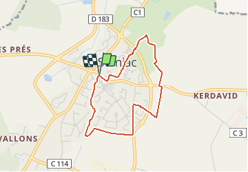
Trail Walking of 3.3 km to be discovered at Brittany, Morbihan, Sulniac. This trail is proposed by gooogor.
Description
Départ Mairie de Sulniac (parking église ou inter).
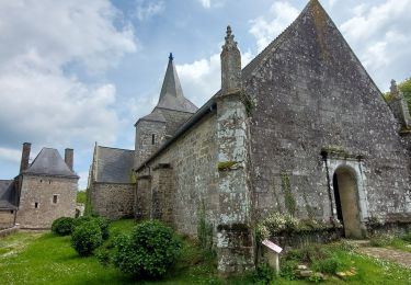
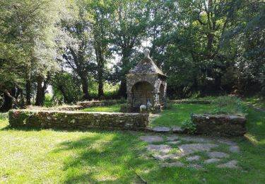
Découvrez la pommeraie (conservatoire), la mini-ferme associative de Ker Avalen, le calvaire en forme de croix bannière du XVIème siècle.
Positioning
Country:
France
Region :
Brittany
Department/Province :
Morbihan
Municipality :
Sulniac
Location:
Unknown
Start:(Dec)
Start:(UTM)
532227 ; 5280325 (30T) N.
Comments
Trails nearby
![Trail Walking Berric - Berric - Circuit des Vertus - Photo](https://media.geolcdn.com/t/375/260/ext.jpg?maxdim=2&url=https%3A%2F%2Fservices.sitytrail.com%2FGeolivesWS%2FDownloadMedia.ashx%3FTrailID%3D178624%26Media%3Da047e8b5-5cf9-4545-b7b7-9961e79ce05d.jpg)
![Walking Walking](https://static1.geolcdn.com/sitytour/trail-icons/101.png)
Berric - Circuit des Vertus
Walking
Easy
(1)
Berric,
Brittany,
Morbihan,
France
![](/images/other/stat-length.png)
11.8 km | 13.7 km-effort
3h 1min
![](https://static1.geolcdn.com/siteimages/upload/files/16400158638029165_repeat_loop_refresh_sync_direction_icon.png)
Yes
![Trail Walking Sulniac - Sulniac_01_LePontQuil_SteMarguerite_20170822 - Photo](https://media.geolcdn.com/t/375/260/ext.jpg?maxdim=2&url=https%3A%2F%2Fstatic1.geolcdn.com%2Fsiteimages%2Fupload%2Ffiles%2F1553511878bg_sport_marche.png)
![Walking Walking](https://static1.geolcdn.com/sitytour/trail-icons/101.png)
Sulniac_01_LePontQuil_SteMarguerite_20170822
Walking
Easy
(1)
Sulniac,
Brittany,
Morbihan,
France
![](/images/other/stat-length.png)
21 km | 25 km-effort
5h 24min
![](https://static1.geolcdn.com/siteimages/upload/files/16400158638029165_repeat_loop_refresh_sync_direction_icon.png)
Yes
![Trail Mountain bike Sulniac - VTT Sulniac Larré Lostihuel Sulniac 01.04.13 - Photo](https://media.geolcdn.com/t/375/260/ext.jpg?maxdim=2&url=https%3A%2F%2Fstatic1.geolcdn.com%2Fsiteimages%2Fupload%2Ffiles%2F1524743154velo.jpg)
![Mountain bike Mountain bike](https://static1.geolcdn.com/sitytour/trail-icons/202.png)
VTT Sulniac Larré Lostihuel Sulniac 01.04.13
Mountain bike
Very easy
(1)
Sulniac,
Brittany,
Morbihan,
France
![](/images/other/stat-length.png)
38 km | 45 km-effort
3h 14min
![](https://static1.geolcdn.com/siteimages/upload/files/16400158638029165_repeat_loop_refresh_sync_direction_icon.png)
Yes
![Trail Walking Treffléan - PR_56_Trefflean_BA_02_Circuit1b_Chemin-De-Cran_20240507 - Photo](https://media.geolcdn.com/t/375/260/ext.jpg?maxdim=2&url=https%3A%2F%2Fmedia.geolcdn.com%2Ff%2Fb832eb83-9ae2-4127-a1d1-f2e6e6666b1a.jpg)
![Walking Walking](https://static1.geolcdn.com/sitytour/trail-icons/101.png)
PR_56_Trefflean_BA_02_Circuit1b_Chemin-De-Cran_20240507
Walking
Easy
Treffléan,
Brittany,
Morbihan,
France
![](/images/other/stat-length.png)
5.4 km | 6.5 km-effort
1h 12min
![](https://static1.geolcdn.com/siteimages/upload/files/16400158638029165_repeat_loop_refresh_sync_direction_icon.png)
Yes
![Trail Walking Sulniac - PR_56_Sulniac_AA_01_Circuit1b_De-Ste-Marguerite_20221111 - Photo](https://media.geolcdn.com/t/375/260/ext.jpg?maxdim=2&url=https%3A%2F%2Fmedia.geolcdn.com%2Ff%2Fabd23342-4330-4c39-959c-ca1d9fbd45b2.jpg)
![Walking Walking](https://static1.geolcdn.com/sitytour/trail-icons/101.png)
PR_56_Sulniac_AA_01_Circuit1b_De-Ste-Marguerite_20221111
Walking
Easy
Sulniac,
Brittany,
Morbihan,
France
![](/images/other/stat-length.png)
7.5 km | 8.8 km-effort
1h 40min
![](https://static1.geolcdn.com/siteimages/upload/files/16400158638029165_repeat_loop_refresh_sync_direction_icon.png)
Yes
![Trail Walking La Vraie-Croix - PR_56_La-Vraie-Croix_AA_01_Circuit1b_De-Langroez_20210808 - Photo](https://media.geolcdn.com/t/375/260/ext.jpg?maxdim=2&url=https%3A%2F%2Fmedia.geolcdn.com%2Ff%2Fe57815d5-9c20-492e-9aa1-a75529639bce.jpg)
![Walking Walking](https://static1.geolcdn.com/sitytour/trail-icons/101.png)
PR_56_La-Vraie-Croix_AA_01_Circuit1b_De-Langroez_20210808
Walking
Easy
La Vraie-Croix,
Brittany,
Morbihan,
France
![](/images/other/stat-length.png)
9 km | 10.8 km-effort
2h 23min
![](https://static1.geolcdn.com/siteimages/upload/files/16400158638029165_repeat_loop_refresh_sync_direction_icon.png)
Yes
![Trail Walking Theix-Noyalo - GRP_Lanvaux_AK_11_Theix_St-Nolf_20210615 - Photo](https://media.geolcdn.com/t/375/260/ext.jpg?maxdim=2&url=https%3A%2F%2Fmedia.geolcdn.com%2Ff%2Fb7d9e276-6ec7-442e-9d5d-291058f86d11.jpg)
![Walking Walking](https://static1.geolcdn.com/sitytour/trail-icons/101.png)
GRP_Lanvaux_AK_11_Theix_St-Nolf_20210615
Walking
Easy
Theix-Noyalo,
Brittany,
Morbihan,
France
![](/images/other/stat-length.png)
17.1 km | 21 km-effort
4h 42min
![](https://static1.geolcdn.com/siteimages/upload/files/16400158638029165_repeat_loop_refresh_sync_direction_icon.png)
No
![Trail Walking Berric - GRP_Lanvaux_AJ_10_Berric_Theix_20210608 - Photo](https://media.geolcdn.com/t/375/260/ext.jpg?maxdim=2&url=https%3A%2F%2Fmedia.geolcdn.com%2Ff%2Fde084bea-3302-489e-8149-e594a415d03e.jpg)
![Walking Walking](https://static1.geolcdn.com/sitytour/trail-icons/101.png)
GRP_Lanvaux_AJ_10_Berric_Theix_20210608
Walking
Easy
Berric,
Brittany,
Morbihan,
France
![](/images/other/stat-length.png)
16.2 km | 19 km-effort
4h 10min
![](https://static1.geolcdn.com/siteimages/upload/files/16400158638029165_repeat_loop_refresh_sync_direction_icon.png)
No
![Trail Walking Sulniac - 215- Boucle Le Gorvello Theix - Photo](https://media.geolcdn.com/t/375/260/ext.jpg?maxdim=2&url=https%3A%2F%2Fmedia.geolcdn.com%2Ff%2F70c6538d-d3f2-405b-adce-eea4c8c52a77.jpg)
![Walking Walking](https://static1.geolcdn.com/sitytour/trail-icons/101.png)
215- Boucle Le Gorvello Theix
Walking
Easy
Sulniac,
Brittany,
Morbihan,
France
![](/images/other/stat-length.png)
14.5 km | 16.5 km-effort
3h 18min
![](https://static1.geolcdn.com/siteimages/upload/files/16400158638029165_repeat_loop_refresh_sync_direction_icon.png)
Yes
Un parcours pour toute la famille, en passant par le chemin de la pomme.