Trail Walking Tecoma - Dandenong - Photo
 phidge
phidge

User

© OpenStreetMap contributors
Length
Length
15.2 km
Max alt
Max alt
477 m
Uphill gradient
Uphill gradient
623 m
Km-Effort
Km-Effort  
23 km
Min alt
Min alt
213 m
Downhill gradient
Downhill gradient
598 m
Boucle
Boucle
No
Creation date :
2019-01-20 16:37:27.984
Updated on :
2019-01-20 16:37:28.044

(0 Reviews)

Walking
Walking
4h51
Difficulty : Unknown

Scan this QR Code to open this trail in the SityTrail application

FREE GPS app for hiking

Logo SityTrail SityTrail

IGN / Geographical institutes

Download SityTrail from the App Store Download SityTrail from Google Play

Logo SityTrail SityTrail World

The world is yours!

Download SityTrail from the App Store Download SityTrail from Google Play Download SityTrail on Huawei AppGallery

About

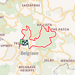
Trail Walking of 15.2 km to be discovered at Victoria, Shire of Yarra Ranges. This trail is proposed by phidge.

Description

copie sur everytrail

Elevation profile

Positioning

Country:
Australia
Region :
Victoria
Department/Province :
Shire of Yarra Ranges
Municipality :
Tecoma
Location:
Unknown
Start:(UTM)
354346 ; 5803082 (55H) S.

Trails nearby

Trail Walking  - park - Photo
Walking
ARPF

Walking

Easy
, Victoria, City of Manningham, Australia
3.7 km | 4.4 km-effort
1h 28min
Yes
Trail Horseback riding  - 13th January 2020 - Photo
Horseback riding
MIA??

Horseback riding

Difficult
, Victoria, Shire of Yarra Ranges, Australia
8 km | 10.3 km-effort
1h 27min
No
Trail Walking  - lysterfield - Photo
Walking
ARPF

Walking

Medium
, Victoria, City of Casey, Australia
6.1 km | 7.3 km-effort
2h 27min
No
Trail Walking  - Mt-Dandenong-Fire-Trail.gpx - Photo
Walking
phidge

Walking

Very easy
, Victoria, Shire of Yarra Ranges, Australia
4 km | 9.2 km-effort
4h 51min
Yes


Close
My subscriptions