![](/images/other/stat-length.png)
![Trail Walking Sanilhac-Sagriès - Sanilhac Chapelle St Veredème - Photo](https://media.geolcdn.com/t/1900/400/ext.pjpeg?maxdim=2&url=https%3A%2F%2Fservices.sitytrail.com%2FGeolivesWS%2FDownloadMedia.ashx%3FTrailID%3D174434%26Media%3D6a95b336-bc10-4ac2-a675-171ea7ce36f5.jpg)
Sanilhac Chapelle St Veredème
CAMBON
User
![Length](/images/other/stat-length.png)
Length
9.5 km
![Max alt](https://static1.geolcdn.com/siteimages/upload/files/1508320355ic_sort_altitude_max_24dp.png)
Max alt
180 m
![Uphill gradient](https://static1.geolcdn.com/siteimages/upload/files/1508320355ic_sort_den_pos_24dp.png)
Uphill gradient
243 m
![Km-Effort](/images/other/stat-length.png)
Km-Effort
12.7 km
![Min alt](https://static1.geolcdn.com/siteimages/upload/files/1508320355ic_sort_altitude_min_24dp.png)
Min alt
42 m
![Downhill gradient](https://static1.geolcdn.com/siteimages/upload/files/1508320355ic_sort_den_neg_24dp.png)
Downhill gradient
243 m
![Boucle](https://static1.geolcdn.com/siteimages/upload/files/16400158638029165_repeat_loop_refresh_sync_direction_icon.png)
Boucle
Yes
Creation date :
2014-12-10 00:00:00.0
Updated on :
2014-12-10 00:00:00.0
![Walking](https://static1.geolcdn.com/sitytour/trail-icons/101.png)
3h00
Difficulty : Medium
![Scan this QR Code to open this trail in the SityTrail application](https://capi.geolives.com/qq0zvz2zws4bq2lad0pu/sitytour/trails/174434/qr.png?size=200)
FREE GPS app for hiking
About
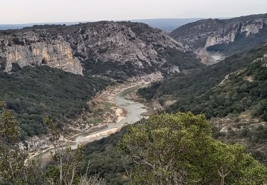
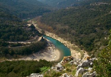
Trail Walking of 9.5 km to be discovered at Occitania, Gard, Sanilhac-Sagriès. This trail is proposed by CAMBON.
Description
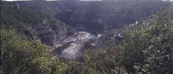
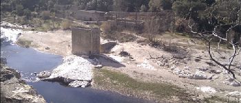
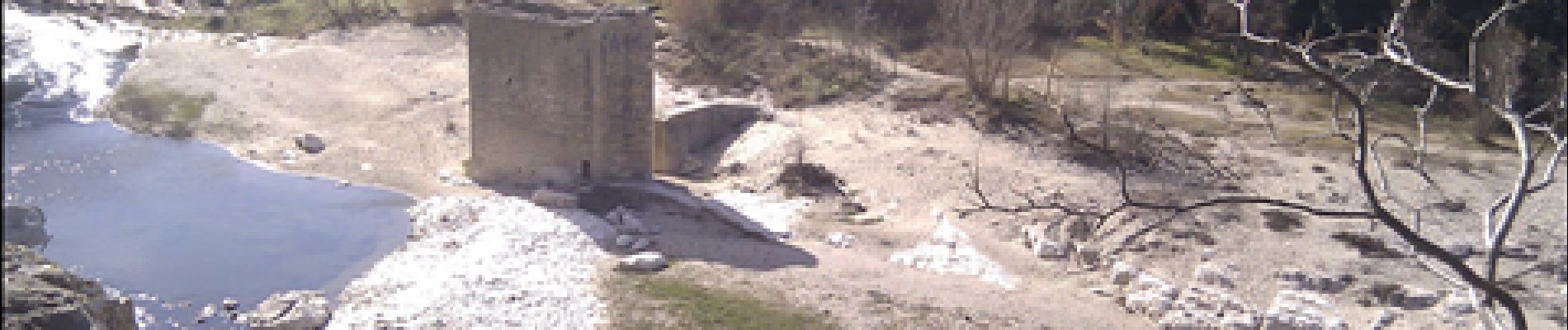
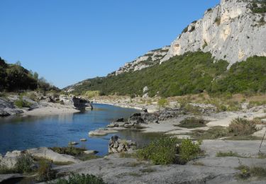
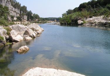
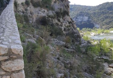
Découverte des Gorges du Gardon
et de la chapelle st Vérédème
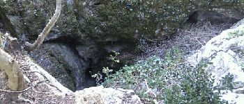
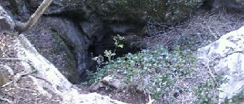
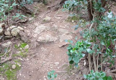
Descente caillouteuse. la remonté peut se faire par le tunnel (fermé du 15/11 au 15/03 et du 01/05 au 15/08) si non remonter par le sentier qui part après le moulin au raz de la falaise. La remonté est abrupte
Positioning
Country:
France
Region :
Occitania
Department/Province :
Gard
Municipality :
Sanilhac-Sagriès
Location:
Unknown
Start:(Dec)
Start:(UTM)
614360 ; 4867706 (31T) N.
Comments
Trails nearby
![Walking Walking](https://static1.geolcdn.com/sitytour/trail-icons/101.png)
PF-Collias - Les Gorges du Gardon
Walking
Easy
(1)
Collias,
Occitania,
Gard,
France
![](/images/other/stat-length.png)
12.9 km | 16.4 km-effort
3h 39min
![](https://static1.geolcdn.com/siteimages/upload/files/16400158638029165_repeat_loop_refresh_sync_direction_icon.png)
Yes
![Trail Running Saint-Maximin - St-Maximin et la vallée d'Eure - Photo](https://media.geolcdn.com/t/375/260/ext.jpg?maxdim=2&url=https%3A%2F%2Fservices.sitytrail.com%2FGeolivesWS%2FDownloadMedia.ashx%3FTrailID%3D173131%26Media%3D14685_6.jpg)
![Running Running](https://static1.geolcdn.com/sitytour/trail-icons/103.png)
St-Maximin et la vallée d'Eure
Running
Medium
(1)
Saint-Maximin,
Occitania,
Gard,
France
![](/images/other/stat-length.png)
18 km | 23 km-effort
2h 0min
![](https://static1.geolcdn.com/siteimages/upload/files/16400158638029165_repeat_loop_refresh_sync_direction_icon.png)
Yes
![Trail Walking Collias - La Baume par Collias - Photo](https://media.geolcdn.com/t/375/260/ext.jpg?maxdim=2&url=https%3A%2F%2Fservices.sitytrail.com%2FGeolivesWS%2FDownloadMedia.ashx%3FTrailID%3D104695%26Media%3D8102_6.jpg)
![Walking Walking](https://static1.geolcdn.com/sitytour/trail-icons/101.png)
La Baume par Collias
Walking
Medium
(3)
Collias,
Occitania,
Gard,
France
![](/images/other/stat-length.png)
13.3 km | 18.1 km-effort
4h 0min
![](https://static1.geolcdn.com/siteimages/upload/files/16400158638029165_repeat_loop_refresh_sync_direction_icon.png)
Yes
![Trail Walking Poulx - Balcon sur Gorges du Gardon - Photo](https://media.geolcdn.com/t/375/260/b4f466dc-2d62-4b2c-95b4-3708a6ba2370.jpg&format=jpg&maxdim=2)
![Walking Walking](https://static1.geolcdn.com/sitytour/trail-icons/101.png)
Balcon sur Gorges du Gardon
Walking
Medium
Poulx,
Occitania,
Gard,
France
![](/images/other/stat-length.png)
17.2 km | 22 km-effort
5h 16min
![](https://static1.geolcdn.com/siteimages/upload/files/16400158638029165_repeat_loop_refresh_sync_direction_icon.png)
Yes
![Trail On foot Collias - L'Ermitage de Collias - Photo](https://media.geolcdn.com/t/375/260/c473495e-e6e8-4c81-b296-56e817ace246.jpeg&format=jpg&maxdim=2)
![On foot On foot](https://static1.geolcdn.com/sitytour/trail-icons/100.png)
L'Ermitage de Collias
On foot
Easy
Collias,
Occitania,
Gard,
France
![](/images/other/stat-length.png)
5.3 km | 7 km-effort
1h 35min
![](https://static1.geolcdn.com/siteimages/upload/files/16400158638029165_repeat_loop_refresh_sync_direction_icon.png)
No
![Trail Walking Cabrières - 30 gardon bois des coufines - Photo](https://media.geolcdn.com/t/375/260/2e1df956-cd25-48f9-b572-2f56a2c48a3c.jpg&format=jpg&maxdim=2)
![Walking Walking](https://static1.geolcdn.com/sitytour/trail-icons/101.png)
30 gardon bois des coufines
Walking
Easy
Cabrières,
Occitania,
Gard,
France
![](/images/other/stat-length.png)
11.4 km | 15.6 km-effort
4h 30min
![](https://static1.geolcdn.com/siteimages/upload/files/16400158638029165_repeat_loop_refresh_sync_direction_icon.png)
No
![Trail Walking Collias - 30 collias - Photo](https://media.geolcdn.com/t/375/260/db6c66c4-7bc5-4df3-945c-25bb4b8058c2.jpg&format=jpg&maxdim=2)
![Walking Walking](https://static1.geolcdn.com/sitytour/trail-icons/101.png)
![Trail Mountain bike Uzès - GARD VTT 2017 J3 - Photo](https://media.geolcdn.com/t/375/260/ext.jpg?maxdim=2&url=https%3A%2F%2Fstatic1.geolcdn.com%2Fsiteimages%2Fupload%2Ffiles%2F1524743154velo.jpg)
![Mountain bike Mountain bike](https://static1.geolcdn.com/sitytour/trail-icons/202.png)
GARD VTT 2017 J3
Mountain bike
Medium
(2)
Uzès,
Occitania,
Gard,
France
![](/images/other/stat-length.png)
48 km | 60 km-effort
3h 53min
![](https://static1.geolcdn.com/siteimages/upload/files/16400158638029165_repeat_loop_refresh_sync_direction_icon.png)
No
![Trail Walking Sanilhac-Sagriès - la baume - Photo](https://media.geolcdn.com/t/375/260/ext.jpg?maxdim=2&url=https%3A%2F%2Fservices.sitytrail.com%2FGeolivesWS%2FDownloadMedia.ashx%3FTrailID%3D393706%26Media%3Dfix__20150308134945.jpg)
![Walking Walking](https://static1.geolcdn.com/sitytour/trail-icons/101.png)
la baume
Walking
Easy
(1)
Sanilhac-Sagriès,
Occitania,
Gard,
France
![](/images/other/stat-length.png)
10.5 km | 14 km-effort
4h 25min
![](https://static1.geolcdn.com/siteimages/upload/files/16400158638029165_repeat_loop_refresh_sync_direction_icon.png)
Yes