![](/images/other/stat-length.png)
![Trail Walking Saint-Marcel-lès-Valence - Balade VSM N°2 Etrau-petits Eynard-Mirabeaux - Photo](https://media.geolcdn.com/t/1900/400/ext.pjpeg?maxdim=2&url=https%3A%2F%2Fstatic1.geolcdn.com%2Fsiteimages%2Fupload%2Ffiles%2F1553511878bg_sport_marche.png)
Balade VSM N°2 Etrau-petits Eynard-Mirabeaux
michelguilhou
User
![Length](/images/other/stat-length.png)
![Max alt](https://static1.geolcdn.com/siteimages/upload/files/1508320355ic_sort_altitude_max_24dp.png)
![Uphill gradient](https://static1.geolcdn.com/siteimages/upload/files/1508320355ic_sort_den_pos_24dp.png)
![Km-Effort](/images/other/stat-length.png)
![Min alt](https://static1.geolcdn.com/siteimages/upload/files/1508320355ic_sort_altitude_min_24dp.png)
![Downhill gradient](https://static1.geolcdn.com/siteimages/upload/files/1508320355ic_sort_den_neg_24dp.png)
![Boucle](https://static1.geolcdn.com/siteimages/upload/files/16400158638029165_repeat_loop_refresh_sync_direction_icon.png)
![Walking](https://static1.geolcdn.com/sitytour/trail-icons/101.png)
1h45
Difficulty : Easy
![Scan this QR Code to open this trail in the SityTrail application](https://capi.geolives.com/qq0zvz2zws4bq2lad0pu/sitytour/trails/174065/qr.png?size=200)
FREE GPS app for hiking
About
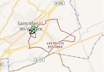
Trail Walking of 7 km to be discovered at Auvergne-Rhône-Alpes, Drôme, Saint-Marcel-lès-Valence. This trail is proposed by michelguilhou.
Description
)Remonter la rue des monts du matin vers le village et Prendre à gauche,la rue des Bois jusqu’au pont sur la déviation (10 minutes)
2) En face de la maison Géry (rénovée en jaune), prendre le chemin à Gauche et marcher 20’( on peut allonger en prenant le chemin à Droite en face de la haie de cerisiers, puis sur la Gauche, et encore à Gauche quand on arrive au pont sur la Barberolle)
3) On arrive sur une petite route en face de la station de pompage, la prendre à Gauche vers les Petits-Eynards. Au rond-point prendre tout droit vers « Les Barris ».
4) A 300m, 10’, des Petits-Eynards, prendre à Droite sur la digue le long de la Barberolle.
5) Après ¼ d’h, au niveau de la balise « céder le passage », prendre la route sur la Gauche
6) Au lieu dit « Les Barris », prendre tout droit en direction des Mirabeaux, la route suit une haie d’arbres, la suivre jusqu’aux Mirabeaux (20’)
7) Dans le hameau « Les Mirabeaux », prendre à Droite sur 30m, puis à Gauche « rue des Mirabeaux », continuer sur la Gauche jusqu’au pont sur la déviation.
8) Après le pont, tourner à Gauche rue des Charmilles puis, en face du stade, rue Pierre de Coubertin, tourner à Droite sur 100m, et prendre sur la Gauche, l’allée du Chênevert . Dans l’allée du Chênevert, prendre le passage à Gauche entre deux maisons jusqu’à la rue des Petits-Eynards.
9) Traverser (sur le passage piéton !) et prendre le chemin des Chênes, puis le chemin des Sauges et rejoindre la MJC puis le gymnase
Points of interest
Positioning
Comments
Trails nearby
![Trail Walking Saint-Marcel-lès-Valence - Balade VSM N° 5 - pour rejoindre le Guimand - Photo](https://media.geolcdn.com/t/375/260/ext.jpg?maxdim=2&url=https%3A%2F%2Fstatic1.geolcdn.com%2Fsiteimages%2Fupload%2Ffiles%2F1553511878bg_sport_marche.png)
![Walking Walking](https://static1.geolcdn.com/sitytour/trail-icons/101.png)
Walking
![](/images/other/stat-length.png)
![](https://static1.geolcdn.com/siteimages/upload/files/16400158638029165_repeat_loop_refresh_sync_direction_icon.png)
![Trail Walking Saint-Marcel-lès-Valence - Vers le Guimand - Photo](https://media.geolcdn.com/t/375/260/57b98d48-2046-42f0-8662-00caa40854e6.jpg&format=jpg&maxdim=2)
![Walking Walking](https://static1.geolcdn.com/sitytour/trail-icons/101.png)
Walking
![](/images/other/stat-length.png)
![](https://static1.geolcdn.com/siteimages/upload/files/16400158638029165_repeat_loop_refresh_sync_direction_icon.png)
![Trail Mountain bike Valence - Grande Traversée des PréAlpes à VTT : Valence - Gap - Sisteron - Photo](https://media.geolcdn.com/t/375/260/ext.jpg?maxdim=2&url=https%3A%2F%2Fservices.sitytrail.com%2FGeolivesWS%2FDownloadMedia.ashx%3FTrailID%3D102172%26Media%3D2562_2.jpg)
![Mountain bike Mountain bike](https://static1.geolcdn.com/sitytour/trail-icons/202.png)
Mountain bike
![](/images/other/stat-length.png)
![](https://static1.geolcdn.com/siteimages/upload/files/16400158638029165_repeat_loop_refresh_sync_direction_icon.png)
![Trail Mountain bike Valence - Grande Traversée des PréAlpes à VTT : Valence - Livron sur Drôme - Photo](https://media.geolcdn.com/t/375/260/ext.jpg?maxdim=2&url=https%3A%2F%2Fservices.sitytrail.com%2FGeolivesWS%2FDownloadMedia.ashx%3FTrailID%3D102153%26Media%3D2543_2.jpg)
![Mountain bike Mountain bike](https://static1.geolcdn.com/sitytour/trail-icons/202.png)
Mountain bike
![](/images/other/stat-length.png)
![](https://static1.geolcdn.com/siteimages/upload/files/16400158638029165_repeat_loop_refresh_sync_direction_icon.png)
![Trail Horseback riding Bourg-lès-Valence - Télégraphe - Photo](https://media.geolcdn.com/t/375/260/6c4e2012-89e1-424c-b59b-88fe72cd426c.jpg&format=jpg&maxdim=2)
![Horseback riding Horseback riding](https://static1.geolcdn.com/sitytour/trail-icons/301.png)
Horseback riding
![](/images/other/stat-length.png)
![](https://static1.geolcdn.com/siteimages/upload/files/16400158638029165_repeat_loop_refresh_sync_direction_icon.png)
![Trail Horseback riding Bourg-lès-Valence - balade 1 - Photo](https://media.geolcdn.com/t/375/260/ext.jpg?maxdim=2&url=https%3A%2F%2Fstatic1.geolcdn.com%2Fsiteimages%2Fupload%2Ffiles%2F1524743154cheval.jpg)
![Horseback riding Horseback riding](https://static1.geolcdn.com/sitytour/trail-icons/301.png)
Horseback riding
![](/images/other/stat-length.png)
![](https://static1.geolcdn.com/siteimages/upload/files/16400158638029165_repeat_loop_refresh_sync_direction_icon.png)
![Trail Walking Valence - Valence 2 - Photo](https://media.geolcdn.com/t/375/260/ext.jpg?maxdim=2&url=https%3A%2F%2Fstatic1.geolcdn.com%2Fsiteimages%2Fupload%2Ffiles%2F1553511878bg_sport_marche.png)
![Walking Walking](https://static1.geolcdn.com/sitytour/trail-icons/101.png)
Walking
![](/images/other/stat-length.png)
![](https://static1.geolcdn.com/siteimages/upload/files/16400158638029165_repeat_loop_refresh_sync_direction_icon.png)
![Trail Road bike Valence - 10 km](https://media.geolcdn.com/t/375/260/ext.jpg?maxdim=2&url=https%3A%2F%2Fstatic1.geolcdn.com%2Fsiteimages%2Fupload%2Ffiles%2F1524743154velo.jpg)
![Road bike Road bike](https://static1.geolcdn.com/sitytour/trail-icons/201.png)
Road bike
![](/images/other/stat-length.png)
![](https://static1.geolcdn.com/siteimages/upload/files/16400158638029165_repeat_loop_refresh_sync_direction_icon.png)
![Trail Road bike Montélier - montelier - Photo](https://media.geolcdn.com/t/375/260/ext.jpg?maxdim=2&url=https%3A%2F%2Fstatic1.geolcdn.com%2Fsiteimages%2Fupload%2Ffiles%2F1524743154velo.jpg)
![Road bike Road bike](https://static1.geolcdn.com/sitytour/trail-icons/201.png)
Road bike
![](/images/other/stat-length.png)
![](https://static1.geolcdn.com/siteimages/upload/files/16400158638029165_repeat_loop_refresh_sync_direction_icon.png)