![](/images/other/stat-length.png)
![Trail Walking Vauvenargues - Pic des mouches (est) - Photo](https://media.geolcdn.com/t/1900/400/ext.pjpeg?maxdim=2&url=https%3A%2F%2Fstatic1.geolcdn.com%2Fsiteimages%2Fupload%2Ffiles%2F1553511878bg_sport_marche.png)
Pic des mouches (est)
lhags
User
![Length](/images/other/stat-length.png)
Length
7.1 km
![Max alt](https://static1.geolcdn.com/siteimages/upload/files/1508320355ic_sort_altitude_max_24dp.png)
Max alt
998 m
![Uphill gradient](https://static1.geolcdn.com/siteimages/upload/files/1508320355ic_sort_den_pos_24dp.png)
Uphill gradient
418 m
![Km-Effort](/images/other/stat-length.png)
Km-Effort
12.6 km
![Min alt](https://static1.geolcdn.com/siteimages/upload/files/1508320355ic_sort_altitude_min_24dp.png)
Min alt
580 m
![Downhill gradient](https://static1.geolcdn.com/siteimages/upload/files/1508320355ic_sort_den_neg_24dp.png)
Downhill gradient
414 m
![Boucle](https://static1.geolcdn.com/siteimages/upload/files/16400158638029165_repeat_loop_refresh_sync_direction_icon.png)
Boucle
Yes
Creation date :
2014-12-10 00:00:00.0
Updated on :
2014-12-10 00:00:00.0
![Walking](https://static1.geolcdn.com/sitytour/trail-icons/101.png)
2h50
Difficulty : Easy
![Scan this QR Code to open this trail in the SityTrail application](https://capi.geolives.com/qq0zvz2zws4bq2lad0pu/sitytour/trails/173431/qr.png?size=200)
FREE GPS app for hiking
About
Trail Walking of 7.1 km to be discovered at Provence-Alpes-Côte d'Azur, Bouches-du-Rhône, Vauvenargues. This trail is proposed by lhags.
Description
Coeff : 11
Fait en février 2013 par -10°, avec 10cm de neige et des pointes à 80km/h de vent.
A refaire par temps plus clément... mais la ballade reste très sympa.
Positioning
Country:
France
Region :
Provence-Alpes-Côte d'Azur
Department/Province :
Bouches-du-Rhône
Municipality :
Vauvenargues
Location:
Unknown
Start:(Dec)
Start:(UTM)
715892 ; 4825421 (31T) N.
Comments
Trails nearby
![Trail Walking Puyloubier - 2023-02-03 Sainte Victoire - Le Pic des Mouches - Photo](https://media.geolcdn.com/t/375/260/485b71fb-d444-48f0-93df-e93d563947c5.jpg&format=jpg&maxdim=2)
![Walking Walking](https://static1.geolcdn.com/sitytour/trail-icons/101.png)
2023-02-03 Sainte Victoire - Le Pic des Mouches
Walking
Difficult
Puyloubier,
Provence-Alpes-Côte d'Azur,
Bouches-du-Rhône,
France
![](/images/other/stat-length.png)
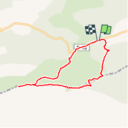
10 km | 19 km-effort
3h 10min
![](https://static1.geolcdn.com/siteimages/upload/files/16400158638029165_repeat_loop_refresh_sync_direction_icon.png)
Yes
![Trail Walking Puyloubier - Pic dès mouches puyloubier - Photo](https://media.geolcdn.com/t/375/260/7c244ec8-1dfe-4d0a-987a-96248fbf499f.jpg&format=jpg&maxdim=2)
![Walking Walking](https://static1.geolcdn.com/sitytour/trail-icons/101.png)
Pic dès mouches puyloubier
Walking
Easy
Puyloubier,
Provence-Alpes-Côte d'Azur,
Bouches-du-Rhône,
France
![](/images/other/stat-length.png)
6.8 km | 15.2 km-effort
4h 52min
![](https://static1.geolcdn.com/siteimages/upload/files/16400158638029165_repeat_loop_refresh_sync_direction_icon.png)
Yes
![Trail Walking Jouques - le Concors - Photo](https://media.geolcdn.com/t/375/260/ext.jpg?maxdim=2&url=https%3A%2F%2Fservices.sitytrail.com%2FGeolivesWS%2FDownloadMedia.ashx%3FTrailID%3D701216%26Media%3Dfix__20170219144003.jpg)
![Walking Walking](https://static1.geolcdn.com/sitytour/trail-icons/101.png)
le Concors
Walking
Easy
Jouques,
Provence-Alpes-Côte d'Azur,
Bouches-du-Rhône,
France
![](/images/other/stat-length.png)
8.5 km | 14.4 km-effort
3h 31min
![](https://static1.geolcdn.com/siteimages/upload/files/16400158638029165_repeat_loop_refresh_sync_direction_icon.png)
Yes
![Trail Walking Puyloubier - traversée St Ser, le pic des Mouches, Puyloubier - Photo](https://media.geolcdn.com/t/375/260/ext.jpg?maxdim=2&url=https%3A%2F%2Fservices.sitytrail.com%2FGeolivesWS%2FDownloadMedia.ashx%3FTrailID%3D544432%26Media%3Dfix__20160326141759.jpg)
![Walking Walking](https://static1.geolcdn.com/sitytour/trail-icons/101.png)
traversée St Ser, le pic des Mouches, Puyloubier
Walking
Difficult
(1)
Puyloubier,
Provence-Alpes-Côte d'Azur,
Bouches-du-Rhône,
France
![](/images/other/stat-length.png)
8.4 km | 16.5 km-effort
5h 47min
![](https://static1.geolcdn.com/siteimages/upload/files/16400158638029165_repeat_loop_refresh_sync_direction_icon.png)
No
![Trail Walking Puyloubier - Le pic des Mouches par le col de St Ser - Photo](https://media.geolcdn.com/t/375/260/ext.jpg?maxdim=2&url=https%3A%2F%2Fservices.sitytrail.com%2FGeolivesWS%2FDownloadMedia.ashx%3FTrailID%3D413729%26Media%3Dfix__20150429115113.jpg)
![Walking Walking](https://static1.geolcdn.com/sitytour/trail-icons/101.png)
Le pic des Mouches par le col de St Ser
Walking
Difficult
Puyloubier,
Provence-Alpes-Côte d'Azur,
Bouches-du-Rhône,
France
![](/images/other/stat-length.png)
6.5 km | 14.7 km-effort
3h 40min
![](https://static1.geolcdn.com/siteimages/upload/files/16400158638029165_repeat_loop_refresh_sync_direction_icon.png)
Yes
![On foot On foot](https://static1.geolcdn.com/sitytour/trail-icons/100.png)
Garagaï de Cagoloup- Ste Victoire-11-12-24
On foot
Medium
Puyloubier,
Provence-Alpes-Côte d'Azur,
Bouches-du-Rhône,
France
![](/images/other/stat-length.png)
17.7 km | 27 km-effort
6h 12min
![](https://static1.geolcdn.com/siteimages/upload/files/16400158638029165_repeat_loop_refresh_sync_direction_icon.png)
Yes
![Trail Walking Puyloubier - Puyloubier : St Ser-col des Portes - Photo](https://media.geolcdn.com/t/375/260/0b56fcca-8759-4413-9017-b9e823aea0a6.jpg&format=jpg&maxdim=2)
![Walking Walking](https://static1.geolcdn.com/sitytour/trail-icons/101.png)
Puyloubier : St Ser-col des Portes
Walking
Difficult
Puyloubier,
Provence-Alpes-Côte d'Azur,
Bouches-du-Rhône,
France
![](/images/other/stat-length.png)
21 km | 34 km-effort
7h 42min
![](https://static1.geolcdn.com/siteimages/upload/files/16400158638029165_repeat_loop_refresh_sync_direction_icon.png)
Yes
![Trail Walking Jouques - Le Concors 21.1.24 - Photo](https://media.geolcdn.com/t/375/260/467ccc2e-fb0d-4f54-a56a-703dc9d45a81.jpg&format=jpg&maxdim=2)
![Walking Walking](https://static1.geolcdn.com/sitytour/trail-icons/101.png)
Le Concors 21.1.24
Walking
Easy
Jouques,
Provence-Alpes-Côte d'Azur,
Bouches-du-Rhône,
France
![](/images/other/stat-length.png)
8.5 km | 14.3 km-effort
2h 30min
![](https://static1.geolcdn.com/siteimages/upload/files/16400158638029165_repeat_loop_refresh_sync_direction_icon.png)
Yes
![Trail Walking Jouques - Mont Concors Taulisson - Photo](https://media.geolcdn.com/t/375/260/3a637119-730f-4246-8f19-4fa752af5ec2.jpg&format=jpg&maxdim=2)
![Walking Walking](https://static1.geolcdn.com/sitytour/trail-icons/101.png)
Mont Concors Taulisson
Walking
Easy
Jouques,
Provence-Alpes-Côte d'Azur,
Bouches-du-Rhône,
France
![](/images/other/stat-length.png)
8.4 km | 13.3 km-effort
2h 45min
![](https://static1.geolcdn.com/siteimages/upload/files/16400158638029165_repeat_loop_refresh_sync_direction_icon.png)
Yes