![](/images/other/stat-length.png)
![Trail Walking Saint-Chef - Randonnée autour de Saint Chef - Photo](https://media.geolcdn.com/t/1900/400/ext.pjpeg?maxdim=2&url=https%3A%2F%2Fservices.sitytrail.com%2FGeolivesWS%2FDownloadMedia.ashx%3FTrailID%3D173262%26Media%3D14880_2.jpg)
Randonnée autour de Saint Chef
tracegps
User
![Length](/images/other/stat-length.png)
Length
10.3 km
![Max alt](https://static1.geolcdn.com/siteimages/upload/files/1508320355ic_sort_altitude_max_24dp.png)
Max alt
427 m
![Uphill gradient](https://static1.geolcdn.com/siteimages/upload/files/1508320355ic_sort_den_pos_24dp.png)
Uphill gradient
158 m
![Km-Effort](/images/other/stat-length.png)
Km-Effort
12.4 km
![Min alt](https://static1.geolcdn.com/siteimages/upload/files/1508320355ic_sort_altitude_min_24dp.png)
Min alt
321 m
![Downhill gradient](https://static1.geolcdn.com/siteimages/upload/files/1508320355ic_sort_den_neg_24dp.png)
Downhill gradient
151 m
![Boucle](https://static1.geolcdn.com/siteimages/upload/files/16400158638029165_repeat_loop_refresh_sync_direction_icon.png)
Boucle
Yes
Creation date :
2014-12-10 00:00:00.0
Updated on :
2014-12-10 00:00:00.0
![Walking](https://static1.geolcdn.com/sitytour/trail-icons/101.png)
3h45
Difficulty : Easy
![Scan this QR Code to open this trail in the SityTrail application](https://capi.geolives.com/qq0zvz2zws4bq2lad0pu/sitytour/trails/173262/qr.png?size=200)
FREE GPS app for hiking
About
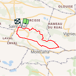
Trail Walking of 10.3 km to be discovered at Auvergne-Rhône-Alpes, Isère, Saint-Chef. This trail is proposed by tracegps.
Description
Il s'agit du circuit "bleu" tracé par le Syndicat d'Initiative de la commune de Saint Chef. Distance théorique: 12 km. Distance réelle 10.3 km et dénivelée de 215m.
Positioning
Country:
France
Region :
Auvergne-Rhône-Alpes
Department/Province :
Isère
Municipality :
Saint-Chef
Location:
Unknown
Start:(Dec)
Start:(UTM)
684703 ; 5055972 (31T) N.
Comments
Trails nearby
![Trail Walking Saint-Chef - Promenade 2022/02/13 - Photo](https://media.geolcdn.com/t/375/260/a2501420-db13-4b70-96e9-ad6164180d66.jpg&format=jpg&maxdim=2)
![Walking Walking](https://static1.geolcdn.com/sitytour/trail-icons/101.png)
Promenade 2022/02/13
Walking
Medium
Saint-Chef,
Auvergne-Rhône-Alpes,
Isère,
France
![](/images/other/stat-length.png)
6.9 km | 8.9 km-effort
1h 23min
![](https://static1.geolcdn.com/siteimages/upload/files/16400158638029165_repeat_loop_refresh_sync_direction_icon.png)
Yes
![Trail Walking Vignieu - Vignieu - Saint Chef - Canal des moines - Photo](https://media.geolcdn.com/t/375/260/ext.jpg?maxdim=2&url=https%3A%2F%2Fstatic1.geolcdn.com%2Fsiteimages%2Fupload%2Ffiles%2F1553511878bg_sport_marche.png)
![Walking Walking](https://static1.geolcdn.com/sitytour/trail-icons/101.png)
Vignieu - Saint Chef - Canal des moines
Walking
Very difficult
Vignieu,
Auvergne-Rhône-Alpes,
Isère,
France
![](/images/other/stat-length.png)
15.6 km | 20 km-effort
4h 34min
![](https://static1.geolcdn.com/siteimages/upload/files/16400158638029165_repeat_loop_refresh_sync_direction_icon.png)
Yes
![Trail Walking Saint-Chef - Courses Saint-Chef - 20220222 - Photo](https://media.geolcdn.com/t/375/260/ext.jpg?maxdim=2&url=https%3A%2F%2Fstatic1.geolcdn.com%2Fsiteimages%2Fupload%2Ffiles%2F1553511878bg_sport_marche.png)
![Walking Walking](https://static1.geolcdn.com/sitytour/trail-icons/101.png)
Courses Saint-Chef - 20220222
Walking
Easy
Saint-Chef,
Auvergne-Rhône-Alpes,
Isère,
France
![](/images/other/stat-length.png)
4.4 km | 5 km-effort
45min
![](https://static1.geolcdn.com/siteimages/upload/files/16400158638029165_repeat_loop_refresh_sync_direction_icon.png)
Yes
![Trail Walking Saint-Chef - Saint chef 2 - Photo](https://media.geolcdn.com/t/375/260/ext.jpg?maxdim=2&url=https%3A%2F%2Fstatic1.geolcdn.com%2Fsiteimages%2Fupload%2Ffiles%2F1553511878bg_sport_marche.png)
![Walking Walking](https://static1.geolcdn.com/sitytour/trail-icons/101.png)
Saint chef 2
Walking
Very easy
(1)
Saint-Chef,
Auvergne-Rhône-Alpes,
Isère,
France
![](/images/other/stat-length.png)
9.6 km | 12.5 km-effort
3h 3min
![](https://static1.geolcdn.com/siteimages/upload/files/16400158638029165_repeat_loop_refresh_sync_direction_icon.png)
Yes
![Trail Walking Montcarra - Sur les hauteurs de Montcarra - Photo](https://media.geolcdn.com/t/375/260/ext.jpg?maxdim=2&url=https%3A%2F%2Fstatic1.geolcdn.com%2Fsiteimages%2Fupload%2Ffiles%2F1553511878bg_sport_marche.png)
![Walking Walking](https://static1.geolcdn.com/sitytour/trail-icons/101.png)
Sur les hauteurs de Montcarra
Walking
Easy
(1)
Montcarra,
Auvergne-Rhône-Alpes,
Isère,
France
![](/images/other/stat-length.png)
6.8 km | 8 km-effort
1h 44min
![](https://static1.geolcdn.com/siteimages/upload/files/16400158638029165_repeat_loop_refresh_sync_direction_icon.png)
Yes
![Trail Walking Saint-Savin - st savin - Photo](https://media.geolcdn.com/t/375/260/ext.jpg?maxdim=2&url=https%3A%2F%2Fstatic1.geolcdn.com%2Fsiteimages%2Fupload%2Ffiles%2F1553511878bg_sport_marche.png)
![Walking Walking](https://static1.geolcdn.com/sitytour/trail-icons/101.png)
st savin
Walking
Very easy
Saint-Savin,
Auvergne-Rhône-Alpes,
Isère,
France
![](/images/other/stat-length.png)
9.9 km | 13.4 km-effort
2h 16min
![](https://static1.geolcdn.com/siteimages/upload/files/16400158638029165_repeat_loop_refresh_sync_direction_icon.png)
No
![Trail sport Saint-Chef - Rando saint chef - Photo](https://media.geolcdn.com/t/375/260/ext.jpg?maxdim=2&url=https%3A%2F%2Fsecurestorage.geolives.com%2Fsitytour%2Ftrail-bg%2Fdefault.jpg)
Rando saint chef
sport
Very easy
Saint-Chef,
Auvergne-Rhône-Alpes,
Isère,
France
![](/images/other/stat-length.png)
10.4 km | 12.6 km-effort
Unknown
![](https://static1.geolcdn.com/siteimages/upload/files/16400158638029165_repeat_loop_refresh_sync_direction_icon.png)
No
![Trail Walking Vignieu - vigneu chevaux - Photo](https://media.geolcdn.com/t/375/260/ext.jpg?maxdim=2&url=https%3A%2F%2Fstatic1.geolcdn.com%2Fsiteimages%2Fupload%2Ffiles%2F1553511878bg_sport_marche.png)
![Walking Walking](https://static1.geolcdn.com/sitytour/trail-icons/101.png)
vigneu chevaux
Walking
Very easy
Vignieu,
Auvergne-Rhône-Alpes,
Isère,
France
![](/images/other/stat-length.png)
3.6 km | 4.3 km-effort
1h 26min
![](https://static1.geolcdn.com/siteimages/upload/files/16400158638029165_repeat_loop_refresh_sync_direction_icon.png)
Yes
![Trail Mountain bike Saint-Savin - st savin - Photo](https://media.geolcdn.com/t/375/260/ext.jpg?maxdim=2&url=https%3A%2F%2Fstatic1.geolcdn.com%2Fsiteimages%2Fupload%2Ffiles%2F1524743154velo.jpg)
![Mountain bike Mountain bike](https://static1.geolcdn.com/sitytour/trail-icons/202.png)
st savin
Mountain bike
Difficult
Saint-Savin,
Auvergne-Rhône-Alpes,
Isère,
France
![](/images/other/stat-length.png)
51 km | 65 km-effort
3h 32min
![](https://static1.geolcdn.com/siteimages/upload/files/16400158638029165_repeat_loop_refresh_sync_direction_icon.png)
Yes
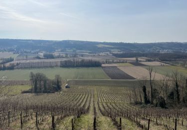
Tres joli paysages. Randonnée accessible.