Trail Walking Val-de-Vière - Boucle à travers les vignes - Val de Vière - Photo

Boucle à travers les vignes - Val de Vière

 tracegps
tracegps

User

© OpenStreetMap contributors
Length
Length
6.9 km
Max alt
Max alt
213 m
Uphill gradient
Uphill gradient
140 m
Km-Effort
Km-Effort  
8.8 km
Min alt
Min alt
147 m
Downhill gradient
Downhill gradient
138 m
Boucle
Boucle
Yes
Creation date :
2014-12-10 00:00:00.0
Updated on :
2014-12-10 00:00:00.0

(0 Reviews)

Walking
Walking
1h45
Difficulty : Easy

Scan this QR Code to open this trail in the SityTrail application

FREE GPS app for hiking

Logo SityTrail SityTrail

IGN / Geographical institutes

Download SityTrail from the App Store Download SityTrail from Google Play

Logo SityTrail SityTrail World

The world is yours!

Download SityTrail from the App Store Download SityTrail from Google Play Download SityTrail on Huawei AppGallery

About

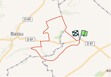
Trail Walking of 6.9 km to be discovered at Grand Est, Marne, Val-de-Vière. This trail is proposed by tracegps.

Description

Boucle depuis le bas des Vignes de Val de Vière. On passe près de Bassu. Rando facile, un peu vallonnée.

Elevation profile

Photos

Positioning

Country:
France
Region :
Grand Est
Department/Province :
Marne
Municipality :
Val-de-Vière
Location:
Unknown
Start:(UTM)
626840 ; 5409951 (31U) N.

Trails nearby

Trail Walking Bassuet - Circuit de Bassuet. - Photo
Walking
tracegps

Walking

Difficult
Bassuet, Grand Est, Marne, France
14 km | 16.8 km-effort
3h 30min
Yes


Close
My subscriptions