![](/images/other/stat-length.png)
![Trail Mountain bike La Neuville-en-Hez - Du mont Volant aux Ployes - La Neuville en Hez - Photo](https://media.geolcdn.com/t/1900/400/ext.pjpeg?maxdim=2&url=https%3A%2F%2Fservices.sitytrail.com%2FGeolivesWS%2FDownloadMedia.ashx%3FTrailID%3D173239%26Media%3D14847_6.jpg)
Du mont Volant aux Ployes - La Neuville en Hez
tracegps
User
![Length](/images/other/stat-length.png)
Length
21 km
![Max alt](https://static1.geolcdn.com/siteimages/upload/files/1508320355ic_sort_altitude_max_24dp.png)
Max alt
168 m
![Uphill gradient](https://static1.geolcdn.com/siteimages/upload/files/1508320355ic_sort_den_pos_24dp.png)
Uphill gradient
376 m
![Km-Effort](/images/other/stat-length.png)
Km-Effort
26 km
![Min alt](https://static1.geolcdn.com/siteimages/upload/files/1508320355ic_sort_altitude_min_24dp.png)
Min alt
59 m
![Downhill gradient](https://static1.geolcdn.com/siteimages/upload/files/1508320355ic_sort_den_neg_24dp.png)
Downhill gradient
376 m
![Boucle](https://static1.geolcdn.com/siteimages/upload/files/16400158638029165_repeat_loop_refresh_sync_direction_icon.png)
Boucle
Yes
Creation date :
2014-12-10 00:00:00.0
Updated on :
2014-12-10 00:00:00.0
![Mountain bike](https://static1.geolcdn.com/sitytour/trail-icons/202.png)
2h45
Difficulty : Difficult
![Scan this QR Code to open this trail in the SityTrail application](https://capi.geolives.com/qq0zvz2zws4bq2lad0pu/sitytour/trails/173239/qr.png?size=200)
FREE GPS app for hiking
About
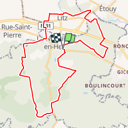
Trail Mountain bike of 21 km to be discovered at Hauts-de-France, Oise, La Neuville-en-Hez. This trail is proposed by tracegps.
Description
Circuit vtt balisé FFC n° 7 au départ du stade de La Neuville en Hez. Retrouvez le circuit sur le site du Comité Départemental du tourisme de l'Oise.
Positioning
Country:
France
Region :
Hauts-de-France
Department/Province :
Oise
Municipality :
La Neuville-en-Hez
Location:
Unknown
Start:(Dec)
Start:(UTM)
451489 ; 5472325 (31U) N.
Comments
Trails nearby
![Trail Walking La Neuville-en-Hez - circuit en Forêt de Hez - Photo](https://media.geolcdn.com/t/375/260/ext.jpg?maxdim=2&url=https%3A%2F%2Fservices.sitytrail.com%2FGeolivesWS%2FDownloadMedia.ashx%3FTrailID%3D180485%26Media%3D20130222145456.jpg)
![Walking Walking](https://static1.geolcdn.com/sitytour/trail-icons/101.png)
circuit en Forêt de Hez
Walking
Medium
La Neuville-en-Hez,
Hauts-de-France,
Oise,
France
![](/images/other/stat-length.png)
8.1 km | 10 km-effort
2h 9min
![](https://static1.geolcdn.com/siteimages/upload/files/16400158638029165_repeat_loop_refresh_sync_direction_icon.png)
Yes
![Trail Walking La Neuville-en-Hez - Bresles - Photo](https://media.geolcdn.com/t/375/260/ext.jpg?maxdim=2&url=https%3A%2F%2Fstatic1.geolcdn.com%2Fsiteimages%2Fupload%2Ffiles%2F1553511878bg_sport_marche.png)
![Walking Walking](https://static1.geolcdn.com/sitytour/trail-icons/101.png)
Bresles
Walking
Difficult
(1)
La Neuville-en-Hez,
Hauts-de-France,
Oise,
France
![](/images/other/stat-length.png)
18.2 km | 22 km-effort
5h 14min
![](https://static1.geolcdn.com/siteimages/upload/files/16400158638029165_repeat_loop_refresh_sync_direction_icon.png)
Yes
![Trail Walking La Rue-Saint-Pierre - Les Chênes verts - Photo](https://media.geolcdn.com/t/375/260/ext.jpg?maxdim=2&url=https%3A%2F%2Fstatic1.geolcdn.com%2Fsiteimages%2Fupload%2Ffiles%2F1553511878bg_sport_marche.png)
![Walking Walking](https://static1.geolcdn.com/sitytour/trail-icons/101.png)
Les Chênes verts
Walking
Medium
La Rue-Saint-Pierre,
Hauts-de-France,
Oise,
France
![](/images/other/stat-length.png)
6.5 km | 7.2 km-effort
1h 35min
![](https://static1.geolcdn.com/siteimages/upload/files/16400158638029165_repeat_loop_refresh_sync_direction_icon.png)
Yes
![Trail Walking Agnetz - le 13 mai - Photo](https://media.geolcdn.com/t/375/260/da7cd7f4-ee7a-4102-b4a1-9d208daec97a.jpg&format=jpg&maxdim=2)
![Walking Walking](https://static1.geolcdn.com/sitytour/trail-icons/101.png)
le 13 mai
Walking
Very easy
Agnetz,
Hauts-de-France,
Oise,
France
![](/images/other/stat-length.png)
15.2 km | 19.3 km-effort
3h 25min
![](https://static1.geolcdn.com/siteimages/upload/files/16400158638029165_repeat_loop_refresh_sync_direction_icon.png)
Yes
![Trail Walking La Rue-Saint-Pierre - 23 les chênes verts - Photo](https://media.geolcdn.com/t/375/260/ext.jpg?maxdim=2&url=https%3A%2F%2Fservices.sitytrail.com%2FGeolivesWS%2FDownloadMedia.ashx%3FTrailID%3D612842%26Media%3Dfix__20160811164220.jpg)
![Walking Walking](https://static1.geolcdn.com/sitytour/trail-icons/101.png)
23 les chênes verts
Walking
Easy
La Rue-Saint-Pierre,
Hauts-de-France,
Oise,
France
![](/images/other/stat-length.png)
7.3 km | 8.1 km-effort
1h 46min
![](https://static1.geolcdn.com/siteimages/upload/files/16400158638029165_repeat_loop_refresh_sync_direction_icon.png)
Yes
![Trail Walking La Neuville-en-Hez - le chêne Chandelier et l'Abbaye de Froidmont - Photo](https://media.geolcdn.com/t/375/260/ext.jpg?maxdim=2&url=https%3A%2F%2Fstatic1.geolcdn.com%2Fsiteimages%2Fupload%2Ffiles%2F1553511878bg_sport_marche.png)
![Walking Walking](https://static1.geolcdn.com/sitytour/trail-icons/101.png)
le chêne Chandelier et l'Abbaye de Froidmont
Walking
Easy
La Neuville-en-Hez,
Hauts-de-France,
Oise,
France
![](/images/other/stat-length.png)
15.7 km | 18.7 km-effort
4h 3min
![](https://static1.geolcdn.com/siteimages/upload/files/16400158638029165_repeat_loop_refresh_sync_direction_icon.png)
Yes
![Trail Walking La Neuville-en-Hez - La Neuville 9 km - Photo](https://media.geolcdn.com/t/375/260/ext.jpg?maxdim=2&url=https%3A%2F%2Fstatic1.geolcdn.com%2Fsiteimages%2Fupload%2Ffiles%2F1553511878bg_sport_marche.png)
![Walking Walking](https://static1.geolcdn.com/sitytour/trail-icons/101.png)
La Neuville 9 km
Walking
Easy
La Neuville-en-Hez,
Hauts-de-France,
Oise,
France
![](/images/other/stat-length.png)
9.7 km | 11.9 km-effort
2h 20min
![](https://static1.geolcdn.com/siteimages/upload/files/16400158638029165_repeat_loop_refresh_sync_direction_icon.png)
Yes
![Trail Walking La Neuville-en-Hez - hez - Photo](https://media.geolcdn.com/t/375/260/ext.jpg?maxdim=2&url=https%3A%2F%2Fstatic1.geolcdn.com%2Fsiteimages%2Fupload%2Ffiles%2F1553511878bg_sport_marche.png)
![Walking Walking](https://static1.geolcdn.com/sitytour/trail-icons/101.png)
hez
Walking
Very easy
La Neuville-en-Hez,
Hauts-de-France,
Oise,
France
![](/images/other/stat-length.png)
9.6 km | 12.2 km-effort
3h 1min
![](https://static1.geolcdn.com/siteimages/upload/files/16400158638029165_repeat_loop_refresh_sync_direction_icon.png)
Yes
![Trail Running Bresles - 24 mars - Photo](https://media.geolcdn.com/t/375/260/ext.jpg?maxdim=2&url=https%3A%2F%2Fstatic1.geolcdn.com%2Fsiteimages%2Fupload%2Ffiles%2F1524743154running.jpg)
![Running Running](https://static1.geolcdn.com/sitytour/trail-icons/103.png)
24 mars
Running
Very easy
Bresles,
Hauts-de-France,
Oise,
France
![](/images/other/stat-length.png)
12 km | 13.3 km-effort
1h 21min
![](https://static1.geolcdn.com/siteimages/upload/files/16400158638029165_repeat_loop_refresh_sync_direction_icon.png)
Yes