![](/images/other/stat-length.png)
![Trail Mountain bike Ploumoguer - 56 Km autour de Ploumoguer - Photo](https://media.geolcdn.com/t/1900/400/ext.pjpeg?maxdim=2&url=https%3A%2F%2Fservices.sitytrail.com%2FGeolivesWS%2FDownloadMedia.ashx%3FTrailID%3D173113%26Media%3D14663_2.jpg)
56 Km autour de Ploumoguer
tracegps
User
![Length](/images/other/stat-length.png)
![Max alt](https://static1.geolcdn.com/siteimages/upload/files/1508320355ic_sort_altitude_max_24dp.png)
![Uphill gradient](https://static1.geolcdn.com/siteimages/upload/files/1508320355ic_sort_den_pos_24dp.png)
![Km-Effort](/images/other/stat-length.png)
![Min alt](https://static1.geolcdn.com/siteimages/upload/files/1508320355ic_sort_altitude_min_24dp.png)
![Downhill gradient](https://static1.geolcdn.com/siteimages/upload/files/1508320355ic_sort_den_neg_24dp.png)
![Boucle](https://static1.geolcdn.com/siteimages/upload/files/16400158638029165_repeat_loop_refresh_sync_direction_icon.png)
![Mountain bike](https://static1.geolcdn.com/sitytour/trail-icons/202.png)
4h15
Difficulty : Difficult
![Scan this QR Code to open this trail in the SityTrail application](https://capi.geolives.com/qq0zvz2zws4bq2lad0pu/sitytour/trails/173113/qr.png?size=200)
FREE GPS app for hiking
About
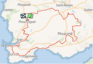
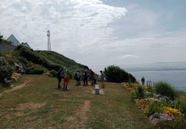
Trail Mountain bike of 57 km to be discovered at Brittany, Finistère, Ploumoguer. This trail is proposed by tracegps.
Description
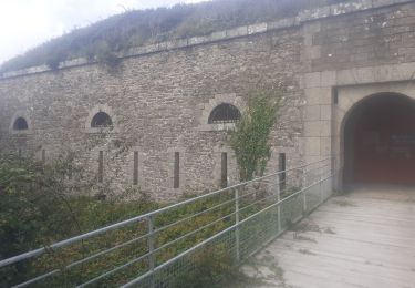
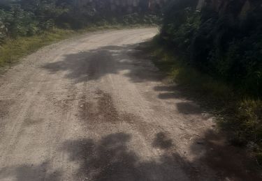
Départ de la mairie de Ploumoguer. Ce circuit à pour but de s'éloigner du bord de mer, afin de ne pas rencontrer beaucoup de promeneur. La traversée de Plouzané, se fait par des chemins que l'on ne soupçonne pas d'exister. Après Plouzané, visite coté sud des carrières. Le retour à Ploumoguer par les chapelles de Bodonnou et des Voleurs est rapide.
Positioning
Comments
Trails nearby
![Trail Walking Lampaul-Plouarzel - N°12a Lampaul-Plouarzel (Plage de Porspaul) - Conquet - Photo](https://media.geolcdn.com/t/375/260/ext.jpg?maxdim=2&url=https%3A%2F%2Fstatic1.geolcdn.com%2Fsiteimages%2Fupload%2Ffiles%2F1553511878bg_sport_marche.png)
![Walking Walking](https://static1.geolcdn.com/sitytour/trail-icons/101.png)
Walking
![](/images/other/stat-length.png)
![](https://static1.geolcdn.com/siteimages/upload/files/16400158638029165_repeat_loop_refresh_sync_direction_icon.png)
![Trail Walking Ploumoguer - Blanc sablons - Photo](https://media.geolcdn.com/t/375/260/9f8a13a6-9108-4438-83a6-64ac4ed746a2.jpg&format=jpg&maxdim=2)
![Walking Walking](https://static1.geolcdn.com/sitytour/trail-icons/101.png)
Walking
![](/images/other/stat-length.png)
![](https://static1.geolcdn.com/siteimages/upload/files/16400158638029165_repeat_loop_refresh_sync_direction_icon.png)
![Trail On foot Le Conquet - AT Face Port Conquet Pte Ker Morvan 10km 200m - Photo](https://media.geolcdn.com/t/375/260/ext.jpg?maxdim=2&url=https%3A%2F%2Fstatic1.geolcdn.com%2Fsiteimages%2Fupload%2Ffiles%2F1545311037marcheuse_200dpi.jpg)
![On foot On foot](https://static1.geolcdn.com/sitytour/trail-icons/100.png)
On foot
![](/images/other/stat-length.png)
![](https://static1.geolcdn.com/siteimages/upload/files/16400158638029165_repeat_loop_refresh_sync_direction_icon.png)
![Trail Walking Le Conquet - 10.09.23 Le Conquet -- Plougonvelin - Photo](https://media.geolcdn.com/t/375/260/be704191-b29d-4776-8e69-0a60ded41783.jpg&format=jpg&maxdim=2)
![Walking Walking](https://static1.geolcdn.com/sitytour/trail-icons/101.png)
Walking
![](/images/other/stat-length.png)
![](https://static1.geolcdn.com/siteimages/upload/files/16400158638029165_repeat_loop_refresh_sync_direction_icon.png)
![Trail Walking Lampaul-Plouarzel - 09.09.23 Lampaul- Plouarzel -- Le Conquet - Photo](https://media.geolcdn.com/t/375/260/888d86e8-0fc8-4dcf-a126-61bf014bddca.jpg&format=jpg&maxdim=2)
![Walking Walking](https://static1.geolcdn.com/sitytour/trail-icons/101.png)
Walking
![](/images/other/stat-length.png)
![](https://static1.geolcdn.com/siteimages/upload/files/16400158638029165_repeat_loop_refresh_sync_direction_icon.png)
![Trail Walking Le Conquet - Le conquet blancs sablons Trezien - Photo](https://media.geolcdn.com/t/375/260/905a5083-f0f2-466e-8fa0-b8ec674abc06.jpg&format=jpg&maxdim=2)
![Walking Walking](https://static1.geolcdn.com/sitytour/trail-icons/101.png)
Walking
![](/images/other/stat-length.png)
![](https://static1.geolcdn.com/siteimages/upload/files/16400158638029165_repeat_loop_refresh_sync_direction_icon.png)
![Trail Walking Le Conquet - Le conquet kermorvan - Photo](https://media.geolcdn.com/t/375/260/03089a66-c39c-48c6-9931-1211906b4ea8.jpg&format=jpg&maxdim=2)
![Walking Walking](https://static1.geolcdn.com/sitytour/trail-icons/101.png)
Walking
![](/images/other/stat-length.png)
![](https://static1.geolcdn.com/siteimages/upload/files/16400158638029165_repeat_loop_refresh_sync_direction_icon.png)
![Trail Nordic walking Le Conquet - au sud du Conquet - Photo](https://media.geolcdn.com/t/375/260/7bfd0afd-c986-434b-b249-395550ba3672.jpg&format=jpg&maxdim=2)
![Nordic walking Nordic walking](https://static1.geolcdn.com/sitytour/trail-icons/102.png)
Nordic walking
![](/images/other/stat-length.png)
![](https://static1.geolcdn.com/siteimages/upload/files/16400158638029165_repeat_loop_refresh_sync_direction_icon.png)
![Trail Walking Lampaul-Plouarzel - Lanpaul - Lochrist - Photo](https://media.geolcdn.com/t/375/260/ef6f4209-61ed-4c81-8584-8b20cf3e3c1d.jpg&format=jpg&maxdim=2)
![Walking Walking](https://static1.geolcdn.com/sitytour/trail-icons/101.png)
Walking
![](/images/other/stat-length.png)
![](https://static1.geolcdn.com/siteimages/upload/files/16400158638029165_repeat_loop_refresh_sync_direction_icon.png)