![](/images/other/stat-length.png)
![Trail Mountain bike Angos - Angos - Sarouilles - Lac de l'Arrêt Darré - Photo](https://media.geolcdn.com/t/1900/400/ext.pjpeg?maxdim=2&url=https%3A%2F%2Fservices.sitytrail.com%2FGeolivesWS%2FDownloadMedia.ashx%3FTrailID%3D173031%26Media%3D14543_2.jpg)
Angos - Sarouilles - Lac de l'Arrêt Darré
tracegps
User
![Length](/images/other/stat-length.png)
Length
26 km
![Max alt](https://static1.geolcdn.com/siteimages/upload/files/1508320355ic_sort_altitude_max_24dp.png)
Max alt
434 m
![Uphill gradient](https://static1.geolcdn.com/siteimages/upload/files/1508320355ic_sort_den_pos_24dp.png)
Uphill gradient
573 m
![Km-Effort](/images/other/stat-length.png)
Km-Effort
34 km
![Min alt](https://static1.geolcdn.com/siteimages/upload/files/1508320355ic_sort_altitude_min_24dp.png)
Min alt
244 m
![Downhill gradient](https://static1.geolcdn.com/siteimages/upload/files/1508320355ic_sort_den_neg_24dp.png)
Downhill gradient
575 m
![Boucle](https://static1.geolcdn.com/siteimages/upload/files/16400158638029165_repeat_loop_refresh_sync_direction_icon.png)
Boucle
Yes
Creation date :
2014-12-10 00:00:00.0
Updated on :
2014-12-10 00:00:00.0
![Mountain bike](https://static1.geolcdn.com/sitytour/trail-icons/202.png)
1h49
Difficulty : Difficult
![Scan this QR Code to open this trail in the SityTrail application](https://capi.geolives.com/qq0zvz2zws4bq2lad0pu/sitytour/trails/173031/qr.png?size=200)
FREE GPS app for hiking
About
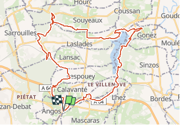
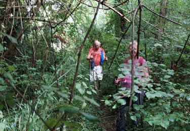
Trail Mountain bike of 26 km to be discovered at Occitania, Hautespyrenees, Angos. This trail is proposed by tracegps.
Description
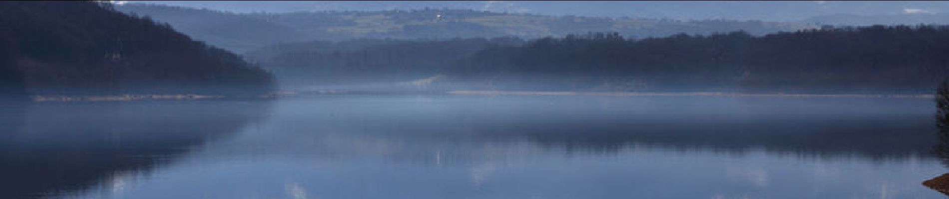
Circuit varié avec une vue imprenable sur les Pyrénées depuis le Lac du l'Arrêt Darré. Il est d'une difficulté que je qualifierai de Moyenne , la difficulté étant fonction du niveau de forme de chacun. Mon Etrex affichait 541m de dénivelé. Bonne balade.
Positioning
Country:
France
Region :
Occitania
Department/Province :
Hautespyrenees
Municipality :
Angos
Location:
Unknown
Start:(Dec)
Start:(UTM)
268998 ; 4786280 (31T) N.
Comments
Trails nearby
![Trail Walking Lhez - lhezlespontsfaif - Photo](https://media.geolcdn.com/t/375/260/ext.jpg?maxdim=2&url=https%3A%2F%2Fservices.sitytrail.com%2FGeolivesWS%2FDownloadMedia.ashx%3FTrailID%3D919394%26Media%3Dfix__20180308184351.jpg)
![Walking Walking](https://static1.geolcdn.com/sitytour/trail-icons/101.png)
lhezlespontsfaif
Walking
Very easy
(1)
Lhez,
Occitania,
Hautespyrenees,
France
![](/images/other/stat-length.png)
11.6 km | 14.9 km-effort
3h 15min
![](https://static1.geolcdn.com/siteimages/upload/files/16400158638029165_repeat_loop_refresh_sync_direction_icon.png)
Yes
![Trail Walking Lhez - lhezlespontsfaif - Photo](https://media.geolcdn.com/t/375/260/ext.jpg?maxdim=2&url=https%3A%2F%2Fservices.sitytrail.com%2FGeolivesWS%2FDownloadMedia.ashx%3FTrailID%3D989266%26Media%3Dfix__20180308184351.jpg)
![Walking Walking](https://static1.geolcdn.com/sitytour/trail-icons/101.png)
lhezlespontsfaif
Walking
Very easy
Lhez,
Occitania,
Hautespyrenees,
France
![](/images/other/stat-length.png)
11.6 km | 14.9 km-effort
3h 15min
![](https://static1.geolcdn.com/siteimages/upload/files/16400158638029165_repeat_loop_refresh_sync_direction_icon.png)
Yes
![Trail On foot Barbazan-Debat - Le Bois de Rebisclou - Photo](https://media.geolcdn.com/t/375/260/0953bc9f-744d-418a-bbb1-ae0b8beb8cae.jpeg&format=jpg&maxdim=2)
![On foot On foot](https://static1.geolcdn.com/sitytour/trail-icons/100.png)
Le Bois de Rebisclou
On foot
Easy
Barbazan-Debat,
Occitania,
Hautespyrenees,
France
![](/images/other/stat-length.png)
9.6 km | 12.7 km-effort
2h 53min
![](https://static1.geolcdn.com/siteimages/upload/files/16400158638029165_repeat_loop_refresh_sync_direction_icon.png)
Yes
![Trail Walking Lhez - Lhez-Les ponts G4 fait en 2021 - Photo](https://media.geolcdn.com/t/375/260/79d492d5-d685-4dae-a0dc-edadd3762085.jpg&format=jpg&maxdim=2)
![Walking Walking](https://static1.geolcdn.com/sitytour/trail-icons/101.png)
Lhez-Les ponts G4 fait en 2021
Walking
Difficult
Lhez,
Occitania,
Hautespyrenees,
France
![](/images/other/stat-length.png)
11.2 km | 14.4 km-effort
3h 22min
![](https://static1.geolcdn.com/siteimages/upload/files/16400158638029165_repeat_loop_refresh_sync_direction_icon.png)
Yes
![Trail Walking Bernac-Debat - bernac les deux fait - Photo](https://media.geolcdn.com/t/375/260/1e412c3f-5b4b-4f0d-a7ad-8d93d1e3b864.jpg&format=jpg&maxdim=2)
![Walking Walking](https://static1.geolcdn.com/sitytour/trail-icons/101.png)
bernac les deux fait
Walking
Very easy
Bernac-Debat,
Occitania,
Hautespyrenees,
France
![](/images/other/stat-length.png)
7.8 km | 9.2 km-effort
2h 40min
![](https://static1.geolcdn.com/siteimages/upload/files/16400158638029165_repeat_loop_refresh_sync_direction_icon.png)
Yes
![Trail Walking Lhez - lhezfaiapied - Photo](https://media.geolcdn.com/t/375/260/ext.jpg?maxdim=2&url=https%3A%2F%2Fservices.sitytrail.com%2FGeolivesWS%2FDownloadMedia.ashx%3FTrailID%3D1010375%26Media%3Dfix__20180725094559.jpg)
![Walking Walking](https://static1.geolcdn.com/sitytour/trail-icons/101.png)
lhezfaiapied
Walking
Very easy
Lhez,
Occitania,
Hautespyrenees,
France
![](/images/other/stat-length.png)
9.5 km | 12.4 km-effort
2h 59min
![](https://static1.geolcdn.com/siteimages/upload/files/16400158638029165_repeat_loop_refresh_sync_direction_icon.png)
Yes
![Trail Walking Séméac - la barthe circuit rouge - Photo](https://media.geolcdn.com/t/375/260/ext.jpg?maxdim=2&url=https%3A%2F%2Fservices.sitytrail.com%2FGeolivesWS%2FDownloadMedia.ashx%3FTrailID%3D324256%26Media%3D20140714174851.jpg)
![Walking Walking](https://static1.geolcdn.com/sitytour/trail-icons/101.png)
la barthe circuit rouge
Walking
Very easy
Séméac,
Occitania,
Hautespyrenees,
France
![](/images/other/stat-length.png)
3.4 km | 4.7 km-effort
59min
![](https://static1.geolcdn.com/siteimages/upload/files/16400158638029165_repeat_loop_refresh_sync_direction_icon.png)
Yes
![Trail Walking Lhez - LHEZG42021 - Photo](https://media.geolcdn.com/t/375/260/a2a5ad57-a158-4fc3-be5b-dbf324450cde.jpg&format=jpg&maxdim=2)
![Walking Walking](https://static1.geolcdn.com/sitytour/trail-icons/101.png)
LHEZG42021
Walking
Medium
Lhez,
Occitania,
Hautespyrenees,
France
![](/images/other/stat-length.png)
7.9 km | 9.7 km-effort
5h 22min
![](https://static1.geolcdn.com/siteimages/upload/files/16400158638029165_repeat_loop_refresh_sync_direction_icon.png)
Yes
![Trail Walking Lhez - lhez les ponts G4 2022 - Photo](https://media.geolcdn.com/t/375/260/323386f1-786c-43c9-99b7-c835ae2b29f4.jpg&format=jpg&maxdim=2)
![Walking Walking](https://static1.geolcdn.com/sitytour/trail-icons/101.png)
lhez les ponts G4 2022
Walking
Difficult
Lhez,
Occitania,
Hautespyrenees,
France
![](/images/other/stat-length.png)
11.9 km | 15.5 km-effort
5h 17min
![](https://static1.geolcdn.com/siteimages/upload/files/16400158638029165_repeat_loop_refresh_sync_direction_icon.png)
Yes