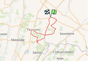
![](/images/other/stat-length.png)
![Trail Cycle Saramon - Circuit découverte 2 - Saramon - Photo](https://media.geolcdn.com/t/1900/400/ext.pjpeg?maxdim=2&url=https%3A%2F%2Fservices.sitytrail.com%2FGeolivesWS%2FDownloadMedia.ashx%3FTrailID%3D172948%26Media%3D14427_5.jpg)
Circuit découverte 2 - Saramon
tracegps
User
![Length](/images/other/stat-length.png)
![Max alt](https://static1.geolcdn.com/siteimages/upload/files/1508320355ic_sort_altitude_max_24dp.png)
![Uphill gradient](https://static1.geolcdn.com/siteimages/upload/files/1508320355ic_sort_den_pos_24dp.png)
![Km-Effort](/images/other/stat-length.png)
![Min alt](https://static1.geolcdn.com/siteimages/upload/files/1508320355ic_sort_altitude_min_24dp.png)
![Downhill gradient](https://static1.geolcdn.com/siteimages/upload/files/1508320355ic_sort_den_neg_24dp.png)
![Boucle](https://static1.geolcdn.com/siteimages/upload/files/16400158638029165_repeat_loop_refresh_sync_direction_icon.png)
![Cycle](https://static1.geolcdn.com/sitytour/trail-icons/200.png)
3h00
Difficulty : Difficult
![Scan this QR Code to open this trail in the SityTrail application](https://capi.geolives.com/qq0zvz2zws4bq2lad0pu/sitytour/trails/172948/qr.png?size=200)
FREE GPS app for hiking
About
Trail Cycle of 50 km to be discovered at Occitania, Gers, Saramon. This trail is proposed by tracegps.
Description
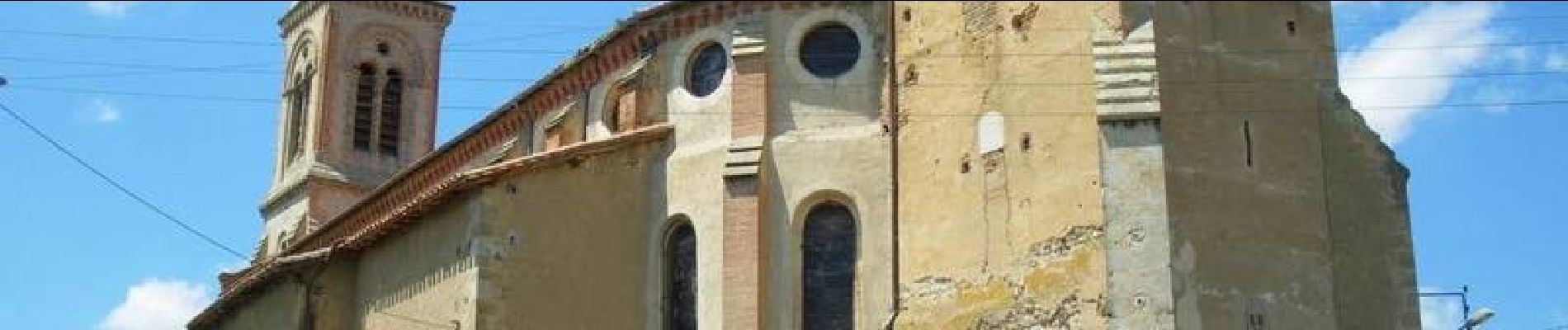
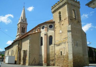
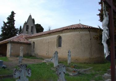
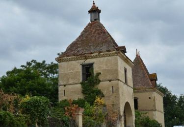
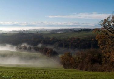
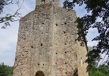
Départ de la place, grande rue, face au Syndicat d'initiative. Partez par "la chaussée", magnifique allée de platanes, en direction de Lombez. Avant le village de Mongauzy, au sommet d'une côte, allez vers St Elix en jetant un coup d'œil sur Saramon. Ce chemin de crête vous offre de vastes panoramas sur la campagne jusqu'au village de St.Elix, tournez vers Pellefigue. Vous allez retrouver ensuite la D 234, pour descendre au village de Simorre. Vous voilà à l'une des étapes essentielles de ce circuit. L'église fortifiée qui trône au milieu du village s'impose à vos yeux. Faites un saut au S.I qui vous fournira toutes les informations historiques et touristiques sur le village et ses alentours. Prenez la direction de Villefranche-Masseube. Tournez vers Masseube. Au bas de Meilhan la D.283 vous conduira au Maquis de Meilhan, haut-lieu de mémoire sur l'un des événements tragiques de la guerre 39-45: une halte grave et émouvante. Rebroussez le chemin vers la D 27 et vous vous retrouvez sur l'une de nos "petites" routes. A Betcave, montez vers l'église. Sur ce chemin qui traverse une campagne sauvage et profonde, vous trouvez "La Ferme Pédagogique du Tuco" qui témoigne d'une vie rurale. Vous retrouvez à Moncorneil-Grazan la vallée de l'Arrats. A Tachoires, vous passez devant un petit édifice qui est, dit-on, la plus petite mairie de France (20 m2). Vous empruntez la route des coteaux, replonger dans la vallée de la Lauze et remonter vers Simorre pour profiter encore de beaux points de vue sur la campagne. A Simorre, tout droit vers Saramon et la boucle est bouclée. Retrouvez le descriptif complet du circuit proposé par le Syndicat d'Initiative de Saramon sur leur site.
Positioning
Comments
Trails nearby
![Trail Walking Boulaur - Un tour à Boulaur par Saramon - Photo](https://media.geolcdn.com/t/375/260/ext.jpg?maxdim=2&url=https%3A%2F%2Fservices.sitytrail.com%2FGeolivesWS%2FDownloadMedia.ashx%3FTrailID%3D111509%26Media%3D7500_2.jpg)
![Walking Walking](https://static1.geolcdn.com/sitytour/trail-icons/101.png)
Walking
![](/images/other/stat-length.png)
![](https://static1.geolcdn.com/siteimages/upload/files/16400158638029165_repeat_loop_refresh_sync_direction_icon.png)
![Trail Cycle Saramon - Circuit de 40 Km- Saramon - Photo](https://media.geolcdn.com/t/375/260/ext.jpg?maxdim=2&url=https%3A%2F%2Fservices.sitytrail.com%2FGeolivesWS%2FDownloadMedia.ashx%3FTrailID%3D172950%26Media%3D14429_5.jpg)
![Cycle Cycle](https://static1.geolcdn.com/sitytour/trail-icons/200.png)
Cycle
![](/images/other/stat-length.png)
![](https://static1.geolcdn.com/siteimages/upload/files/16400158638029165_repeat_loop_refresh_sync_direction_icon.png)
![Trail Cycle Saramon - Circuit de 48 Km- Saramon - Photo](https://media.geolcdn.com/t/375/260/ext.jpg?maxdim=2&url=https%3A%2F%2Fservices.sitytrail.com%2FGeolivesWS%2FDownloadMedia.ashx%3FTrailID%3D172949%26Media%3D14428_1.jpg)
![Cycle Cycle](https://static1.geolcdn.com/sitytour/trail-icons/200.png)
Cycle
![](/images/other/stat-length.png)
![](https://static1.geolcdn.com/siteimages/upload/files/16400158638029165_repeat_loop_refresh_sync_direction_icon.png)
![Trail Cycle Saramon - Circuit découverte 1 - Saramon - Photo](https://media.geolcdn.com/t/375/260/ext.jpg?maxdim=2&url=https%3A%2F%2Fservices.sitytrail.com%2FGeolivesWS%2FDownloadMedia.ashx%3FTrailID%3D172947%26Media%3D14426_4.jpg)
![Cycle Cycle](https://static1.geolcdn.com/sitytour/trail-icons/200.png)
Cycle
![](/images/other/stat-length.png)
![](https://static1.geolcdn.com/siteimages/upload/files/16400158638029165_repeat_loop_refresh_sync_direction_icon.png)
![Trail Cycle Saramon - Circuit découverte 3 - Saramon - Photo](https://media.geolcdn.com/t/375/260/ext.jpg?maxdim=2&url=https%3A%2F%2Fservices.sitytrail.com%2FGeolivesWS%2FDownloadMedia.ashx%3FTrailID%3D172946%26Media%3D14425_5.jpg)
![Cycle Cycle](https://static1.geolcdn.com/sitytour/trail-icons/200.png)
Cycle
![](/images/other/stat-length.png)
![](https://static1.geolcdn.com/siteimages/upload/files/16400158638029165_repeat_loop_refresh_sync_direction_icon.png)
![Trail Cycle Saramon - Circuit de 44 Km- Saramon - Photo](https://media.geolcdn.com/t/375/260/ext.jpg?maxdim=2&url=https%3A%2F%2Fservices.sitytrail.com%2FGeolivesWS%2FDownloadMedia.ashx%3FTrailID%3D172945%26Media%3D14424_5.jpg)
![Cycle Cycle](https://static1.geolcdn.com/sitytour/trail-icons/200.png)
Cycle
![](/images/other/stat-length.png)
![](https://static1.geolcdn.com/siteimages/upload/files/16400158638029165_repeat_loop_refresh_sync_direction_icon.png)
![Trail Mountain bike Simorre - Du cours de la Lauze à Faget-Abatial - Photo](https://media.geolcdn.com/t/375/260/ext.jpg?maxdim=2&url=https%3A%2F%2Fservices.sitytrail.com%2FGeolivesWS%2FDownloadMedia.ashx%3FTrailID%3D317104%26Media%3D16252_2.jpg)
![Mountain bike Mountain bike](https://static1.geolcdn.com/sitytour/trail-icons/202.png)
Mountain bike
![](/images/other/stat-length.png)
![](https://static1.geolcdn.com/siteimages/upload/files/16400158638029165_repeat_loop_refresh_sync_direction_icon.png)
![Trail Walking Saramon - saramon boulor lartigue - Photo](https://media.geolcdn.com/t/375/260/ext.jpg?maxdim=2&url=https%3A%2F%2Fstatic1.geolcdn.com%2Fsiteimages%2Fupload%2Ffiles%2F1553511878bg_sport_marche.png)
![Walking Walking](https://static1.geolcdn.com/sitytour/trail-icons/101.png)
Walking
![](/images/other/stat-length.png)
![](https://static1.geolcdn.com/siteimages/upload/files/16400158638029165_repeat_loop_refresh_sync_direction_icon.png)
![Trail Walking Boulaur - Le chemin des Pèlerins a Boulaur - Photo](https://media.geolcdn.com/t/375/260/ext.jpg?maxdim=2&url=https%3A%2F%2Fstatic1.geolcdn.com%2Fsiteimages%2Fupload%2Ffiles%2F1553511878bg_sport_marche.png)
![Walking Walking](https://static1.geolcdn.com/sitytour/trail-icons/101.png)
Walking
![](/images/other/stat-length.png)
![](https://static1.geolcdn.com/siteimages/upload/files/16400158638029165_repeat_loop_refresh_sync_direction_icon.png)