![](/images/other/stat-length.png)
![Trail Mountain bike Laval - Laval par le Genest et Olivet - Photo](https://media.geolcdn.com/t/1900/400/ext.pjpeg?maxdim=2&url=https%3A%2F%2Fservices.sitytrail.com%2FGeolivesWS%2FDownloadMedia.ashx%3FTrailID%3D172863%26Media%3D14315_5.jpg)
Laval par le Genest et Olivet
tracegps
User
![Length](/images/other/stat-length.png)
Length
42 km
![Max alt](https://static1.geolcdn.com/siteimages/upload/files/1508320355ic_sort_altitude_max_24dp.png)
Max alt
167 m
![Uphill gradient](https://static1.geolcdn.com/siteimages/upload/files/1508320355ic_sort_den_pos_24dp.png)
Uphill gradient
480 m
![Km-Effort](/images/other/stat-length.png)
Km-Effort
48 km
![Min alt](https://static1.geolcdn.com/siteimages/upload/files/1508320355ic_sort_altitude_min_24dp.png)
Min alt
77 m
![Downhill gradient](https://static1.geolcdn.com/siteimages/upload/files/1508320355ic_sort_den_neg_24dp.png)
Downhill gradient
479 m
![Boucle](https://static1.geolcdn.com/siteimages/upload/files/16400158638029165_repeat_loop_refresh_sync_direction_icon.png)
Boucle
Yes
Creation date :
2014-12-10 00:00:00.0
Updated on :
2014-12-10 00:00:00.0
![Mountain bike](https://static1.geolcdn.com/sitytour/trail-icons/202.png)
3h00
Difficulty : Medium
![Scan this QR Code to open this trail in the SityTrail application](https://capi.geolives.com/qq0zvz2zws4bq2lad0pu/sitytour/trails/172863/qr.png?size=200)
FREE GPS app for hiking
About
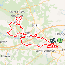
Trail Mountain bike of 42 km to be discovered at Pays de la Loire, Mayenne, Laval. This trail is proposed by tracegps.
Description
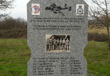
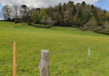
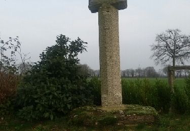
Passage par les marches de Bretagne. Site à voir : l'abbaye de Clermont à coté d'Olivet. Circuit à faire en période de sécheresse sinon quelques passages très boueux.
Positioning
Country:
France
Region :
Pays de la Loire
Department/Province :
Mayenne
Municipality :
Laval
Location:
Unknown
Start:(Dec)
Start:(UTM)
663950 ; 5327336 (30U) N.
Comments
Trails nearby
![Trail Mountain bike Laval - Saint Berthevin par le golf de Change et Ecologia à Louverné - Photo](https://media.geolcdn.com/t/375/260/ext.jpg?maxdim=2&url=https%3A%2F%2Fservices.sitytrail.com%2FGeolivesWS%2FDownloadMedia.ashx%3FTrailID%3D118719%26Media%3D12908_2.jpg)
![Mountain bike Mountain bike](https://static1.geolcdn.com/sitytour/trail-icons/202.png)
Saint Berthevin par le golf de Change et Ecologia à Louverné
Mountain bike
Difficult
(1)
Laval,
Pays de la Loire,
Mayenne,
France
![](/images/other/stat-length.png)
40 km | 46 km-effort
2h 30min
![](https://static1.geolcdn.com/siteimages/upload/files/16400158638029165_repeat_loop_refresh_sync_direction_icon.png)
Yes
![Trail Walking Laval - Tour du pays de Laval(bois de l'Huisserie , Nuillé sur Vicoin) - Photo](https://media.geolcdn.com/t/375/260/ext.jpg?maxdim=2&url=https%3A%2F%2Fservices.sitytrail.com%2FGeolivesWS%2FDownloadMedia.ashx%3FTrailID%3D725470%26Media%3Dfix__20170402181328.jpg)
![Walking Walking](https://static1.geolcdn.com/sitytour/trail-icons/101.png)
Tour du pays de Laval(bois de l'Huisserie , Nuillé sur Vicoin)
Walking
Medium
Laval,
Pays de la Loire,
Mayenne,
France
![](/images/other/stat-length.png)
15.8 km | 19 km-effort
3h 15min
![](https://static1.geolcdn.com/siteimages/upload/files/16400158638029165_repeat_loop_refresh_sync_direction_icon.png)
No
![Trail Walking Laval - tour du pays de laval (Laval, bois de l'Huisserie)l - Photo](https://media.geolcdn.com/t/375/260/ext.jpg?maxdim=2&url=https%3A%2F%2Fservices.sitytrail.com%2FGeolivesWS%2FDownloadMedia.ashx%3FTrailID%3D697748%26Media%3Dfix__20170212170933.jpg)
![Walking Walking](https://static1.geolcdn.com/sitytour/trail-icons/101.png)
tour du pays de laval (Laval, bois de l'Huisserie)l
Walking
Easy
Laval,
Pays de la Loire,
Mayenne,
France
![](/images/other/stat-length.png)
14.7 km | 17.2 km-effort
2h 55min
![](https://static1.geolcdn.com/siteimages/upload/files/16400158638029165_repeat_loop_refresh_sync_direction_icon.png)
No
![Trail Walking Changé - Changé tour du golf - Photo](https://media.geolcdn.com/t/375/260/ext.jpg?maxdim=2&url=https%3A%2F%2Fservices.sitytrail.com%2FGeolivesWS%2FDownloadMedia.ashx%3FTrailID%3D554957%26Media%3Dfix__20160417171039.jpg)
![Walking Walking](https://static1.geolcdn.com/sitytour/trail-icons/101.png)
Changé tour du golf
Walking
Medium
Changé,
Pays de la Loire,
Mayenne,
France
![](/images/other/stat-length.png)
9.3 km | 10.9 km-effort
2h 0min
![](https://static1.geolcdn.com/siteimages/upload/files/16400158638029165_repeat_loop_refresh_sync_direction_icon.png)
Yes
![Trail Mountain bike Laval - Laval par le bois de l'Huisserie, le bois de Gamats et St Pierre le Potier - Photo](https://media.geolcdn.com/t/375/260/ext.jpg?maxdim=2&url=https%3A%2F%2Fservices.sitytrail.com%2FGeolivesWS%2FDownloadMedia.ashx%3FTrailID%3D129699%26Media%3D13238_3.jpg)
![Mountain bike Mountain bike](https://static1.geolcdn.com/sitytour/trail-icons/202.png)
Laval par le bois de l'Huisserie, le bois de Gamats et St Pierre le Potier
Mountain bike
Difficult
Laval,
Pays de la Loire,
Mayenne,
France
![](/images/other/stat-length.png)
42 km | 49 km-effort
3h 15min
![](https://static1.geolcdn.com/siteimages/upload/files/16400158638029165_repeat_loop_refresh_sync_direction_icon.png)
Yes
![Trail On foot Changé - Sentier de randonnée pédestre #10 - Photo](https://media.geolcdn.com/t/375/260/67db2f05-4ef1-49bc-b8cb-2aabe0b67e8f.jpeg&format=jpg&maxdim=2)
![On foot On foot](https://static1.geolcdn.com/sitytour/trail-icons/100.png)
Sentier de randonnée pédestre #10
On foot
Easy
Changé,
Pays de la Loire,
Mayenne,
France
![](/images/other/stat-length.png)
5.3 km | 6 km-effort
1h 22min
![](https://static1.geolcdn.com/siteimages/upload/files/16400158638029165_repeat_loop_refresh_sync_direction_icon.png)
No
![Trail Walking L'Huisserie - Autour de L'Huisserie vers Entammes - Photo](https://media.geolcdn.com/t/375/260/a6eda134-3a58-4ba9-a822-77c4c89ff710.jpg&format=jpg&maxdim=2)
![Walking Walking](https://static1.geolcdn.com/sitytour/trail-icons/101.png)
Autour de L'Huisserie vers Entammes
Walking
Medium
L'Huisserie,
Pays de la Loire,
Mayenne,
France
![](/images/other/stat-length.png)
12.1 km | 14.9 km-effort
2h 52min
![](https://static1.geolcdn.com/siteimages/upload/files/16400158638029165_repeat_loop_refresh_sync_direction_icon.png)
Yes
![Trail Walking L'Huisserie - Tour de l'Huisserie - Photo](https://media.geolcdn.com/t/375/260/ext.jpg?maxdim=2&url=https%3A%2F%2Fservices.sitytrail.com%2FGeolivesWS%2FDownloadMedia.ashx%3FTrailID%3D826332%26Media%3Dfix__20151227155200.jpg)
![Walking Walking](https://static1.geolcdn.com/sitytour/trail-icons/101.png)
Tour de l'Huisserie
Walking
Easy
L'Huisserie,
Pays de la Loire,
Mayenne,
France
![](/images/other/stat-length.png)
11 km | 13 km-effort
2h 10min
![](https://static1.geolcdn.com/siteimages/upload/files/16400158638029165_repeat_loop_refresh_sync_direction_icon.png)
Yes
![Trail Other activity Laval - fifi - Photo](https://media.geolcdn.com/t/375/260/ext.jpg?maxdim=2&url=https%3A%2F%2Fstatic1.geolcdn.com%2Fsiteimages%2Fupload%2Ffiles%2F1545311037marcheuse_200dpi.jpg)
![Other activity Other activity](https://static1.geolcdn.com/sitytour/trail-icons/900.png)
fifi
Other activity
Very easy
Laval,
Pays de la Loire,
Mayenne,
France
![](/images/other/stat-length.png)
32 km | 37 km-effort
28min
![](https://static1.geolcdn.com/siteimages/upload/files/16400158638029165_repeat_loop_refresh_sync_direction_icon.png)
No