![](/images/other/stat-length.png)
![Trail Mountain bike Gespunsart - De Gesponsart à Neufmanil - Photo](https://media.geolcdn.com/t/1900/400/ext.pjpeg?maxdim=2&url=https%3A%2F%2Fservices.sitytrail.com%2FGeolivesWS%2FDownloadMedia.ashx%3FTrailID%3D172854%26Media%3D14304_4.jpg)
De Gesponsart à Neufmanil
tracegps
User
![Length](/images/other/stat-length.png)
Length
15.2 km
![Max alt](https://static1.geolcdn.com/siteimages/upload/files/1508320355ic_sort_altitude_max_24dp.png)
Max alt
364 m
![Uphill gradient](https://static1.geolcdn.com/siteimages/upload/files/1508320355ic_sort_den_pos_24dp.png)
Uphill gradient
423 m
![Km-Effort](/images/other/stat-length.png)
Km-Effort
21 km
![Min alt](https://static1.geolcdn.com/siteimages/upload/files/1508320355ic_sort_altitude_min_24dp.png)
Min alt
171 m
![Downhill gradient](https://static1.geolcdn.com/siteimages/upload/files/1508320355ic_sort_den_neg_24dp.png)
Downhill gradient
421 m
![Boucle](https://static1.geolcdn.com/siteimages/upload/files/16400158638029165_repeat_loop_refresh_sync_direction_icon.png)
Boucle
Yes
Creation date :
2014-12-10 00:00:00.0
Updated on :
2014-12-10 00:00:00.0
![Mountain bike](https://static1.geolcdn.com/sitytour/trail-icons/202.png)
2h15
Difficulty : Difficult
![Scan this QR Code to open this trail in the SityTrail application](https://capi.geolives.com/qq0zvz2zws4bq2lad0pu/sitytour/trails/172854/qr.png?size=200)
FREE GPS app for hiking
About
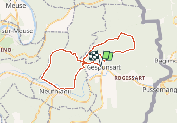
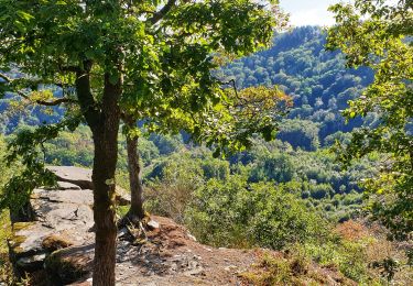
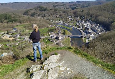
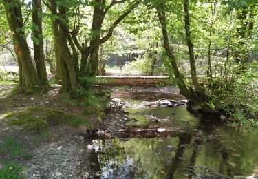
Trail Mountain bike of 15.2 km to be discovered at Grand Est, Ardennes, Gespunsart. This trail is proposed by tracegps.
Description
Boucle surtout dans les bois. Bons chemins en général. Petits passages de montée ardue. Difficulté selon météo. Démarrage à l'église de Gesponsart ou à Neufmanil (aux terrains de pétanque).
Positioning
Country:
France
Region :
Grand Est
Department/Province :
Ardennes
Municipality :
Gespunsart
Location:
Unknown
Start:(Dec)
Start:(UTM)
631447 ; 5520374 (31U) N.
Comments
Trails nearby
![Trail Walking Vresse-sur-Semois - Bohan. Natura 2000, des sites qui valent le détour ! Na2 - Photo](https://media.geolcdn.com/t/375/260/ext.jpg?maxdim=2&url=https%3A%2F%2Fservices.sitytrail.com%2FGeolivesWS%2FDownloadMedia.ashx%3FTrailID%3D161427%26Media%3D5b0af75e-f56d-4b09-8a76-627d51a6ce1b.JPG)
![Walking Walking](https://static1.geolcdn.com/sitytour/trail-icons/101.png)
Bohan. Natura 2000, des sites qui valent le détour ! Na2
Walking
Easy
(1)
Vresse-sur-Semois,
Wallonia,
Namur,
Belgium
![](/images/other/stat-length.png)
4.8 km | 7.8 km-effort
1h 41min
![](https://static1.geolcdn.com/siteimages/upload/files/16400158638029165_repeat_loop_refresh_sync_direction_icon.png)
Yes
![Trail Walking Haulmé - Thilay - Haulmé - Navaux - Photo](https://media.geolcdn.com/t/375/260/ext.jpg?maxdim=2&url=https%3A%2F%2Fservices.sitytrail.com%2FGeolivesWS%2FDownloadMedia.ashx%3FTrailID%3D214837%26Media%3D15355_6.jpg)
![Walking Walking](https://static1.geolcdn.com/sitytour/trail-icons/101.png)
Thilay - Haulmé - Navaux
Walking
Medium
(3)
Haulmé,
Grand Est,
Ardennes,
France
![](/images/other/stat-length.png)
15.3 km | 21 km-effort
3h 15min
![](https://static1.geolcdn.com/siteimages/upload/files/16400158638029165_repeat_loop_refresh_sync_direction_icon.png)
Yes
![Trail Walking Nouzonville - Rando. Nouzonville FFSP - Photo](https://media.geolcdn.com/t/375/260/ext.jpg?maxdim=2&url=https%3A%2F%2Fservices.sitytrail.com%2FGeolivesWS%2FDownloadMedia.ashx%3FTrailID%3D756986%26Media%3D20170521131908.jpg)
![Walking Walking](https://static1.geolcdn.com/sitytour/trail-icons/101.png)
Rando. Nouzonville FFSP
Walking
Medium
(1)
Nouzonville,
Grand Est,
Ardennes,
France
![](/images/other/stat-length.png)
15.9 km | 21 km-effort
3h 55min
![](https://static1.geolcdn.com/siteimages/upload/files/16400158638029165_repeat_loop_refresh_sync_direction_icon.png)
Yes
![Walking Walking](https://static1.geolcdn.com/sitytour/trail-icons/101.png)
Promenade de la Croix - Bohan
Walking
Medium
(1)
Vresse-sur-Semois,
Wallonia,
Namur,
Belgium
![](/images/other/stat-length.png)
5.2 km | 8.3 km-effort
2h 57min
![](https://static1.geolcdn.com/siteimages/upload/files/16400158638029165_repeat_loop_refresh_sync_direction_icon.png)
Yes
![Trail Walking Vresse-sur-Semois - Promenade de la Table des Fées à Bohan - Photo](https://media.geolcdn.com/t/375/260/60ef2e5c-f3fa-416c-a603-6417ffcdf58a.jpeg&format=jpg&maxdim=2)
![Walking Walking](https://static1.geolcdn.com/sitytour/trail-icons/101.png)
Promenade de la Table des Fées à Bohan
Walking
Medium
(1)
Vresse-sur-Semois,
Wallonia,
Namur,
Belgium
![](/images/other/stat-length.png)
4.8 km | 6.8 km-effort
2h 59min
![](https://static1.geolcdn.com/siteimages/upload/files/16400158638029165_repeat_loop_refresh_sync_direction_icon.png)
Yes
![Trail On foot Vresse-sur-Semois - La Vallée des baraques - Photo](https://media.geolcdn.com/t/375/260/ext.jpg?maxdim=2&url=https%3A%2F%2Fpivotmedia.tourismewallonie.be%2FOTH-A0-0058-0K6V%2FOTH-A0-0058-0K6V.jpg)
![On foot On foot](https://static1.geolcdn.com/sitytour/trail-icons/100.png)
La Vallée des baraques
On foot
Easy
Vresse-sur-Semois,
Wallonia,
Namur,
Belgium
![](/images/other/stat-length.png)
11.4 km | 17.1 km-effort
3h 52min
![](https://static1.geolcdn.com/siteimages/upload/files/16400158638029165_repeat_loop_refresh_sync_direction_icon.png)
Yes
![Trail On foot Vresse-sur-Semois - Le vera - Photo](https://media.geolcdn.com/t/375/260/ext.jpg?maxdim=2&url=https%3A%2F%2Fpivotmedia.tourismewallonie.be%2FOTH-A0-0069-3HF2%2FOTH-A0-0069-3HF2.jpg)
![On foot On foot](https://static1.geolcdn.com/sitytour/trail-icons/100.png)
![Trail On foot Vresse-sur-Semois - La Croix - Photo](https://media.geolcdn.com/t/375/260/ext.jpg?maxdim=2&url=https%3A%2F%2Fpivotmedia.tourismewallonie.be%2FOTH-A0-0069-3GE0%2FOTH-A0-0069-3GE0.jpg)
![On foot On foot](https://static1.geolcdn.com/sitytour/trail-icons/100.png)
La Croix
On foot
Easy
Vresse-sur-Semois,
Wallonia,
Namur,
Belgium
![](/images/other/stat-length.png)
4.9 km | 7.9 km-effort
1h 48min
![](https://static1.geolcdn.com/siteimages/upload/files/16400158638029165_repeat_loop_refresh_sync_direction_icon.png)
Yes
![Trail On foot Vresse-sur-Semois - Les dolimarts - Photo](https://media.geolcdn.com/t/375/260/ext.jpg?maxdim=2&url=https%3A%2F%2Fpivotmedia.tourismewallonie.be%2FOTH-A0-005T-1NO4%2FOTH-A0-005T-1NO4.jpg)
![On foot On foot](https://static1.geolcdn.com/sitytour/trail-icons/100.png)
Les dolimarts
On foot
Easy
Vresse-sur-Semois,
Wallonia,
Namur,
Belgium
![](/images/other/stat-length.png)
4.2 km | 6.4 km-effort
1h 27min
![](https://static1.geolcdn.com/siteimages/upload/files/16400158638029165_repeat_loop_refresh_sync_direction_icon.png)
Yes