![](/images/other/stat-length.png)
![Trail Mountain bike Villeneuve-sur-Lot - De Villeneuve sur Lot à Saint Aubin - Photo](https://media.geolcdn.com/t/1900/400/ext.pjpeg?maxdim=2&url=https%3A%2F%2Fservices.sitytrail.com%2FGeolivesWS%2FDownloadMedia.ashx%3FTrailID%3D172851%26Media%3D14300_1.jpg)
De Villeneuve sur Lot à Saint Aubin
tracegps
User
![Length](/images/other/stat-length.png)
Length
40 km
![Max alt](https://static1.geolcdn.com/siteimages/upload/files/1508320355ic_sort_altitude_max_24dp.png)
Max alt
224 m
![Uphill gradient](https://static1.geolcdn.com/siteimages/upload/files/1508320355ic_sort_den_pos_24dp.png)
Uphill gradient
788 m
![Km-Effort](/images/other/stat-length.png)
Km-Effort
51 km
![Min alt](https://static1.geolcdn.com/siteimages/upload/files/1508320355ic_sort_altitude_min_24dp.png)
Min alt
71 m
![Downhill gradient](https://static1.geolcdn.com/siteimages/upload/files/1508320355ic_sort_den_neg_24dp.png)
Downhill gradient
789 m
![Boucle](https://static1.geolcdn.com/siteimages/upload/files/16400158638029165_repeat_loop_refresh_sync_direction_icon.png)
Boucle
Yes
Creation date :
2014-12-10 00:00:00.0
Updated on :
2014-12-10 00:00:00.0
![Mountain bike](https://static1.geolcdn.com/sitytour/trail-icons/202.png)
3h00
Difficulty : Difficult
![Scan this QR Code to open this trail in the SityTrail application](https://capi.geolives.com/qq0zvz2zws4bq2lad0pu/sitytour/trails/172851/qr.png?size=200)
FREE GPS app for hiking
About
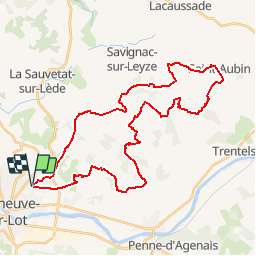
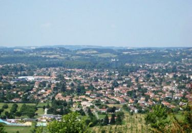
Trail Mountain bike of 40 km to be discovered at New Aquitaine, Lot-et-Garonne, Villeneuve-sur-Lot. This trail is proposed by tracegps.
Description
Boucle de 40km partant de l’église d'Eysses à Villeneuve sur Lot et passant par le village de Saint Aubin. Quelques beaux points de vue mais qui se méritent en particulier au "Pech Moutié" à coté de La Marsale et à la "plaine du pech du Rouet".
Positioning
Country:
France
Region :
New Aquitaine
Department/Province :
Lot-et-Garonne
Municipality :
Villeneuve-sur-Lot
Location:
Unknown
Start:(Dec)
Start:(UTM)
318758 ; 4920869 (31T) N.
Comments
Trails nearby
![Trail Walking Pujols - Pujols, panoramas sur les vallées du Lot et du Mail - Pays de la vallée du Lot - Photo](https://media.geolcdn.com/t/375/260/ext.jpg?maxdim=2&url=https%3A%2F%2Fservices.sitytrail.com%2FGeolivesWS%2FDownloadMedia.ashx%3FTrailID%3D111060%26Media%3D6429_1.jpg)
![Walking Walking](https://static1.geolcdn.com/sitytour/trail-icons/101.png)
Pujols, panoramas sur les vallées du Lot et du Mail - Pays de la vallée du Lot
Walking
Difficult
(1)
Pujols,
New Aquitaine,
Lot-et-Garonne,
France
![](/images/other/stat-length.png)
11.7 km | 17.3 km-effort
3h 15min
![](https://static1.geolcdn.com/siteimages/upload/files/16400158638029165_repeat_loop_refresh_sync_direction_icon.png)
Yes
![Trail On foot Pujols - Pujols - Vallée de la Mail - 10.5 - Photo](https://media.geolcdn.com/t/375/260/97153406-0c05-4b5f-b34a-208fbe2a09a2.jpeg&format=jpg&maxdim=2)
![On foot On foot](https://static1.geolcdn.com/sitytour/trail-icons/100.png)
Pujols - Vallée de la Mail - 10.5
On foot
Easy
Pujols,
New Aquitaine,
Lot-et-Garonne,
France
![](/images/other/stat-length.png)
7.3 km | 11.3 km-effort
2h 33min
![](https://static1.geolcdn.com/siteimages/upload/files/16400158638029165_repeat_loop_refresh_sync_direction_icon.png)
Yes
![Trail On foot Pujols - Pujols - Petit-Tour - 5,5km - Photo](https://media.geolcdn.com/t/375/260/f645a14f-f70e-4c93-bc7f-4dfdb58b1b24.jpeg&format=jpg&maxdim=2)
![On foot On foot](https://static1.geolcdn.com/sitytour/trail-icons/100.png)
Pujols - Petit-Tour - 5,5km
On foot
Easy
Pujols,
New Aquitaine,
Lot-et-Garonne,
France
![](/images/other/stat-length.png)
5 km | 7.4 km-effort
1h 40min
![](https://static1.geolcdn.com/siteimages/upload/files/16400158638029165_repeat_loop_refresh_sync_direction_icon.png)
No
![Trail Walking Pujols - La balade de Pujols 47 - Photo](https://media.geolcdn.com/t/375/260/c3ed0a75-1a75-4388-8301-a233e7ccb1ce.jpg&format=jpg&maxdim=2)
![Walking Walking](https://static1.geolcdn.com/sitytour/trail-icons/101.png)
La balade de Pujols 47
Walking
Very easy
Pujols,
New Aquitaine,
Lot-et-Garonne,
France
![](/images/other/stat-length.png)
7.7 km | 11.7 km-effort
3h 5min
![](https://static1.geolcdn.com/siteimages/upload/files/16400158638029165_repeat_loop_refresh_sync_direction_icon.png)
Yes
![Trail Cycle Villeneuve-sur-Lot - de Villeneuve sur Lot à Moissac en passant par Aiguillon - Photo](https://media.geolcdn.com/t/375/260/ext.jpg?maxdim=2&url=https%3A%2F%2Fservices.sitytrail.com%2FGeolivesWS%2FDownloadMedia.ashx%3FTrailID%3D588391%26Media%3Df4638f96-87eb-466a-9d9d-69a168ebcbb2.JPG)
![Cycle Cycle](https://static1.geolcdn.com/sitytour/trail-icons/200.png)
de Villeneuve sur Lot à Moissac en passant par Aiguillon
Cycle
Medium
Villeneuve-sur-Lot,
New Aquitaine,
Lot-et-Garonne,
France
![](/images/other/stat-length.png)
129 km | 143 km-effort
6h 0min
![](https://static1.geolcdn.com/siteimages/upload/files/16400158638029165_repeat_loop_refresh_sync_direction_icon.png)
No
![Trail Walking Bias - La balade de Senelles - Bias - Photo](https://media.geolcdn.com/t/375/260/ext.jpg?maxdim=2&url=https%3A%2F%2Fservices.sitytrail.com%2FGeolivesWS%2FDownloadMedia.ashx%3FTrailID%3D318107%26Media%3D17568_3.jpg)
![Walking Walking](https://static1.geolcdn.com/sitytour/trail-icons/101.png)
La balade de Senelles - Bias
Walking
Easy
Bias,
New Aquitaine,
Lot-et-Garonne,
France
![](/images/other/stat-length.png)
4.4 km | 4.8 km-effort
1h 30min
![](https://static1.geolcdn.com/siteimages/upload/files/16400158638029165_repeat_loop_refresh_sync_direction_icon.png)
Yes
![Trail On foot Villeneuve-sur-Lot - Saint-Germain, l’autre colline de Villeneuve-sur-Lot - 10,3km - Photo](https://media.geolcdn.com/t/375/260/ext.jpg?maxdim=2&url=https%3A%2F%2Fstatic1.geolcdn.com%2Fsiteimages%2Fupload%2Ffiles%2F1545311037marcheuse_200dpi.jpg)
![On foot On foot](https://static1.geolcdn.com/sitytour/trail-icons/100.png)
Saint-Germain, l’autre colline de Villeneuve-sur-Lot - 10,3km
On foot
Easy
Villeneuve-sur-Lot,
New Aquitaine,
Lot-et-Garonne,
France
![](/images/other/stat-length.png)
10 km | 14.5 km-effort
3h 17min
![](https://static1.geolcdn.com/siteimages/upload/files/16400158638029165_repeat_loop_refresh_sync_direction_icon.png)
Yes
![Trail On foot Villeneuve-sur-Lot - Saint-Germain, aux portes de Villeneuve-sur-Lot - 4,2km - Photo](https://media.geolcdn.com/t/375/260/ext.jpg?maxdim=2&url=https%3A%2F%2Fstatic1.geolcdn.com%2Fsiteimages%2Fupload%2Ffiles%2F1545311037marcheuse_200dpi.jpg)
![On foot On foot](https://static1.geolcdn.com/sitytour/trail-icons/100.png)
Saint-Germain, aux portes de Villeneuve-sur-Lot - 4,2km
On foot
Easy
Villeneuve-sur-Lot,
New Aquitaine,
Lot-et-Garonne,
France
![](/images/other/stat-length.png)
4 km | 5.7 km-effort
1h 17min
![](https://static1.geolcdn.com/siteimages/upload/files/16400158638029165_repeat_loop_refresh_sync_direction_icon.png)
Yes
![Trail Equestrian Pujols - Pujols, la randonnée de Doumillac - Pays de la vallée du Lot - Photo](https://media.geolcdn.com/t/375/260/ext.jpg?maxdim=2&url=https%3A%2F%2Fservices.sitytrail.com%2FGeolivesWS%2FDownloadMedia.ashx%3FTrailID%3D112394%26Media%3D10517_2.jpg)
![Equestrian Equestrian](https://static1.geolcdn.com/sitytour/trail-icons/300.png)
Pujols, la randonnée de Doumillac - Pays de la vallée du Lot
Equestrian
Medium
Pujols,
New Aquitaine,
Lot-et-Garonne,
France
![](/images/other/stat-length.png)
13.1 km | 18.4 km-effort
2h 19min
![](https://static1.geolcdn.com/siteimages/upload/files/16400158638029165_repeat_loop_refresh_sync_direction_icon.png)
Yes