![](/images/other/stat-length.png)
![Trail Walking La Hague - Montagnes russes de Vauville à Jobourg - Photo](https://media.geolcdn.com/t/1900/400/ext.pjpeg?maxdim=2&url=https%3A%2F%2Fservices.sitytrail.com%2FGeolivesWS%2FDownloadMedia.ashx%3FTrailID%3D172780%26Media%3D14206_2.jpg)
Montagnes russes de Vauville à Jobourg
tracegps
User
![Length](/images/other/stat-length.png)
Length
27 km
![Max alt](https://static1.geolcdn.com/siteimages/upload/files/1508320355ic_sort_altitude_max_24dp.png)
Max alt
176 m
![Uphill gradient](https://static1.geolcdn.com/siteimages/upload/files/1508320355ic_sort_den_pos_24dp.png)
Uphill gradient
894 m
![Km-Effort](/images/other/stat-length.png)
Km-Effort
39 km
![Min alt](https://static1.geolcdn.com/siteimages/upload/files/1508320355ic_sort_altitude_min_24dp.png)
Min alt
3 m
![Downhill gradient](https://static1.geolcdn.com/siteimages/upload/files/1508320355ic_sort_den_neg_24dp.png)
Downhill gradient
895 m
![Boucle](https://static1.geolcdn.com/siteimages/upload/files/16400158638029165_repeat_loop_refresh_sync_direction_icon.png)
Boucle
Yes
Creation date :
2014-12-10 00:00:00.0
Updated on :
2014-12-10 00:00:00.0
![Walking](https://static1.geolcdn.com/sitytour/trail-icons/101.png)
5h30
Difficulty : Difficult
![Scan this QR Code to open this trail in the SityTrail application](https://capi.geolives.com/qq0zvz2zws4bq2lad0pu/sitytour/trails/172780/qr.png?size=200)
FREE GPS app for hiking
About
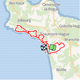
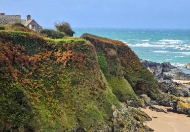
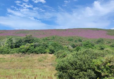
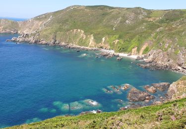
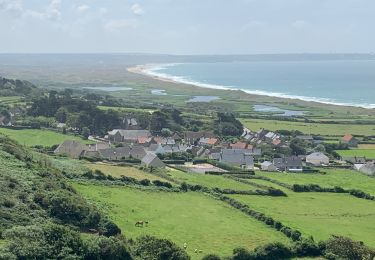
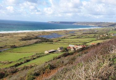
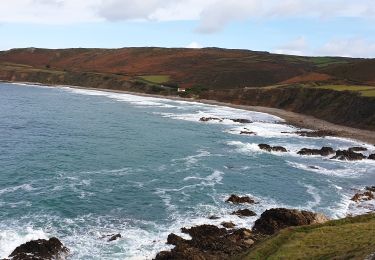
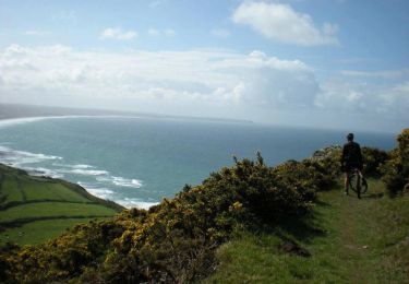
Trail Walking of 27 km to be discovered at Normandy, Manche, La Hague. This trail is proposed by tracegps.
Description
Départ; Parking plage de la Devise. Enchainement de 27 kilomètres de montées et de descentes. Une bonne après-midi de marche dans un paysage de lande grandiose et de côte rocheuse majestueuse. À déguster sans modération.
Positioning
Country:
France
Region :
Normandy
Department/Province :
Manche
Municipality :
La Hague
Location:
Vauville
Start:(Dec)
Start:(UTM)
583026 ; 5498680 (30U) N.
Comments
Trails nearby
![Trail Cycle La Hague - La Haguarde Bitumeuse 2011 - Gréville Hague - Photo](https://media.geolcdn.com/t/375/260/ext.jpg?maxdim=2&url=https%3A%2F%2Fservices.sitytrail.com%2FGeolivesWS%2FDownloadMedia.ashx%3FTrailID%3D106083%26Media%3D10276_1.jpg)
![Cycle Cycle](https://static1.geolcdn.com/sitytour/trail-icons/200.png)
La Haguarde Bitumeuse 2011 - Gréville Hague
Cycle
Medium
(1)
La Hague,
Normandy,
Manche,
France
![](/images/other/stat-length.png)
61 km | 72 km-effort
2h 0min
![](https://static1.geolcdn.com/siteimages/upload/files/16400158638029165_repeat_loop_refresh_sync_direction_icon.png)
Yes
![Trail Walking La Hague - Séjour Cotentin Etape 4 Biville - Les Pieux - Photo](https://media.geolcdn.com/t/375/260/20c319c1-9c7e-4f29-bee7-385fa39e6485.jpg&format=jpg&maxdim=2)
![Walking Walking](https://static1.geolcdn.com/sitytour/trail-icons/101.png)
Séjour Cotentin Etape 4 Biville - Les Pieux
Walking
Difficult
La Hague,
Normandy,
Manche,
France
![](/images/other/stat-length.png)
29 km | 35 km-effort
6h 55min
![](https://static1.geolcdn.com/siteimages/upload/files/16400158638029165_repeat_loop_refresh_sync_direction_icon.png)
No
![Trail Walking La Hague - ioupi biville 01 - Photo](https://media.geolcdn.com/t/375/260/ext.jpg?maxdim=2&url=https%3A%2F%2Fstatic1.geolcdn.com%2Fsiteimages%2Fupload%2Ffiles%2F1553511878bg_sport_marche.png)
![Walking Walking](https://static1.geolcdn.com/sitytour/trail-icons/101.png)
ioupi biville 01
Walking
Easy
(1)
La Hague,
Normandy,
Manche,
France
![](/images/other/stat-length.png)
9.5 km | 11.3 km-effort
2h 11min
![](https://static1.geolcdn.com/siteimages/upload/files/16400158638029165_repeat_loop_refresh_sync_direction_icon.png)
Yes
![Trail Walking La Hague - Vauville - Photo](https://media.geolcdn.com/t/375/260/2b220e39-b1b1-4526-a0cf-9eab92539eb2.jpg&format=jpg&maxdim=2)
![Walking Walking](https://static1.geolcdn.com/sitytour/trail-icons/101.png)
![Trail Walking La Hague - Vauville - Côte Soufflée A/R - Photo](https://media.geolcdn.com/t/375/260/eb27b005-2ab1-4642-aace-d7963dce8dc5.jpg&format=jpg&maxdim=2)
![Walking Walking](https://static1.geolcdn.com/sitytour/trail-icons/101.png)
Vauville - Côte Soufflée A/R
Walking
Very difficult
La Hague,
Normandy,
Manche,
France
![](/images/other/stat-length.png)
22 km | 33 km-effort
4h 32min
![](https://static1.geolcdn.com/siteimages/upload/files/16400158638029165_repeat_loop_refresh_sync_direction_icon.png)
Yes
![Trail Walking La Hague - Gag - Photo](https://media.geolcdn.com/t/375/260/b3b09df4-3380-48d8-b0c7-2a859452b91a.jpg&format=jpg&maxdim=2)
![Walking Walking](https://static1.geolcdn.com/sitytour/trail-icons/101.png)
![Trail Walking La Hague - Vauville, dunes de Biville Héauville - Photo](https://media.geolcdn.com/t/375/260/26dd8ef3-68e9-4a0b-a9e4-59cc22a7a231.jpg&format=jpg&maxdim=2)
![Walking Walking](https://static1.geolcdn.com/sitytour/trail-icons/101.png)
Vauville, dunes de Biville Héauville
Walking
Easy
La Hague,
Normandy,
Manche,
France
![](/images/other/stat-length.png)
21 km | 25 km-effort
4h 13min
![](https://static1.geolcdn.com/siteimages/upload/files/16400158638029165_repeat_loop_refresh_sync_direction_icon.png)
Yes
![Trail Walking La Hague - Herquemoulin-Cap de la Hague - Photo](https://media.geolcdn.com/t/375/260/5a35c261-cb44-47dd-89d5-6c3138309710.jpg&format=jpg&maxdim=2)
![Walking Walking](https://static1.geolcdn.com/sitytour/trail-icons/101.png)
Herquemoulin-Cap de la Hague
Walking
Difficult
La Hague,
Normandy,
Manche,
France
![](/images/other/stat-length.png)
16.9 km | 26 km-effort
4h 9min
![](https://static1.geolcdn.com/siteimages/upload/files/16400158638029165_repeat_loop_refresh_sync_direction_icon.png)
Yes
![Trail Mountain bike La Hague - La Banane à Vauville - Photo](https://media.geolcdn.com/t/375/260/ext.jpg?maxdim=2&url=https%3A%2F%2Fservices.sitytrail.com%2FGeolivesWS%2FDownloadMedia.ashx%3FTrailID%3D215233%26Media%3D15852_3.jpg)
![Mountain bike Mountain bike](https://static1.geolcdn.com/sitytour/trail-icons/202.png)
La Banane à Vauville
Mountain bike
Difficult
La Hague,
Normandy,
Manche,
France
![](/images/other/stat-length.png)
42 km | 56 km-effort
3h 30min
![](https://static1.geolcdn.com/siteimages/upload/files/16400158638029165_repeat_loop_refresh_sync_direction_icon.png)
Yes