Trail Mountain bike Breuillet - Les Vallées Breuilletoises 2012 - Photo

Les Vallées Breuilletoises 2012

 tracegps
tracegps

User

© OpenStreetMap contributors
Length
Length
37 km
Max alt
Max alt
169 m
Uphill gradient
Uphill gradient
637 m
Km-Effort
Km-Effort  
45 km
Min alt
Min alt
52 m
Downhill gradient
Downhill gradient
637 m
Boucle
Boucle
Yes
Creation date :
2014-12-10 00:00:00.0
Updated on :
2014-12-10 00:00:00.0

(0 Reviews)

Mountain bike
Mountain bike
2h00
Difficulty : Difficult

Scan this QR Code to open this trail in the SityTrail application

FREE GPS app for hiking

Logo SityTrail SityTrail

IGN / Geographical institutes

Download SityTrail from the App Store Download SityTrail from Google Play

Logo SityTrail SityTrail World

The world is yours!

Download SityTrail from the App Store Download SityTrail from Google Play Download SityTrail on Huawei AppGallery

About

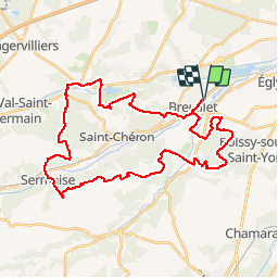
Trail Mountain bike of 37 km to be discovered at Ile-de-France, Essonne, Breuillet. This trail is proposed by tracegps.

Description

Circuit de 37 km pour un peu plus de 500 m de dénivelé avec en alternance chemin-forêt et un peu de bitume.

Elevation profile

Photos

Positioning

Country:
France
Region :
Ile-de-France
Department/Province :
Essonne
Municipality :
Breuillet
Location:
Unknown
Start:(UTM)
439486 ; 5379949 (31U) N.

Trails nearby

Trail Walking Saint-Sulpice-de-Favières - Les Pétales de Souzy - Photo
Walking
tracegps

Walking

Difficult
(1)
Saint-Sulpice-de-Favières, Ile-de-France, Essonne, France
23 km | 29 km-effort
4h 49min
Yes
Trail Walking Saint-Maurice-Montcouronne - Boucle St Maurice Montcouronne - Brigitte - Photo
Walking
GUIDE
chessyca

Walking

Very easy
Saint-Maurice-Montcouronne, Ile-de-France, Essonne, France
21 km | 24 km-effort
4h 19min
Yes
Trail On foot Saint-Yon - Sur les traces de la Renarde - Photo
On foot
GUIDE+

On foot

Very difficult
Saint-Yon, Ile-de-France, Essonne, France
38 km | 44 km-effort
10h 4min
No
Trail Walking Saint-Sulpice-de-Favières - St Sulpice - Photo
Walking
Auger91

Walking

Medium
(1)
Saint-Sulpice-de-Favières, Ile-de-France, Essonne, France
8 km | 10.1 km-effort
2h 18min
Yes
Trail Mountain bike Fontenay-lès-Briis - Soucy / Le Marais - Photo
Mountain bike
Bora431

Mountain bike

Medium
(2)
Fontenay-lès-Briis, Ile-de-France, Essonne, France
25 km | 30 km-effort
1h 52min
Yes
Trail Walking Boissy-sous-Saint-Yon - Carrière de Madagascar  - Photo
Walking
danbott

Walking

Very easy
(1)
Boissy-sous-Saint-Yon, Ile-de-France, Essonne, France
13.2 km | 16.5 km-effort
2h 59min
Yes
Trail Walking Saint-Chéron - Saint-Cheron - l'Orge - Photo
Walking
guydu41

Walking

Medium
Saint-Chéron, Ile-de-France, Essonne, France
8.3 km | 10.4 km-effort
2h 21min
Yes
Trail Walking Saint-Chéron - De Saint Chéron à Dourdan par les côteaux de la rive gauche - Photo
Walking
philippebenne

Walking

Difficult
(1)
Saint-Chéron, Ile-de-France, Essonne, France
13.5 km | 17 km-effort
3h 51min
No
Trail Walking Saint-Sulpice-de-Favières - Saint-Sulpice-de-Favières - Photo
Walking
guydu41

Walking

Medium
Saint-Sulpice-de-Favières, Ile-de-France, Essonne, France
7.5 km | 9.4 km-effort
1h 55min
Yes


Close
My subscriptions