![](/images/other/stat-length.png)
![Trail Mountain bike Revin - Dames de Meuse - Calvaire du Maquis des Manises - Laifour - Photo](https://media.geolcdn.com/t/1900/400/ext.pjpeg?maxdim=2&url=https%3A%2F%2Fservices.sitytrail.com%2FGeolivesWS%2FDownloadMedia.ashx%3FTrailID%3D172735%26Media%3D14133_5.jpg)
Dames de Meuse - Calvaire du Maquis des Manises - Laifour
tracegps
User
![Length](/images/other/stat-length.png)
![Max alt](https://static1.geolcdn.com/siteimages/upload/files/1508320355ic_sort_altitude_max_24dp.png)
![Uphill gradient](https://static1.geolcdn.com/siteimages/upload/files/1508320355ic_sort_den_pos_24dp.png)
![Km-Effort](/images/other/stat-length.png)
![Min alt](https://static1.geolcdn.com/siteimages/upload/files/1508320355ic_sort_altitude_min_24dp.png)
![Downhill gradient](https://static1.geolcdn.com/siteimages/upload/files/1508320355ic_sort_den_neg_24dp.png)
![Boucle](https://static1.geolcdn.com/siteimages/upload/files/16400158638029165_repeat_loop_refresh_sync_direction_icon.png)
![Mountain bike](https://static1.geolcdn.com/sitytour/trail-icons/202.png)
2h45
Difficulty : Difficult
![Scan this QR Code to open this trail in the SityTrail application](https://capi.geolives.com/qq0zvz2zws4bq2lad0pu/sitytour/trails/172735/qr.png?size=200)
FREE GPS app for hiking
About
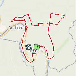
Trail Mountain bike of 22 km to be discovered at Grand Est, Ardennes, Revin. This trail is proposed by tracegps.
Description
Boucle commençant et finissant par la voie verte le long de la Meuse. Montée ardue à travers bois sur un chemin qui par deux fois est encombré de végétation sur 20 m (passer à travers). Au sommet, ne pas s'occuper du balisage orange. Dès qu'on est sur la route au panneau "Le père des chênes", on peut prendre à droite pour faire un crochet (boucle) de 10 minutes vers le calvaire des Manises. La trace GPS de ce crochet par le calvaire n'est pas enregistrée mais c'est très bien indiqué. Pour revenir suivre le sentier passant par les croix blanches de souvenir des massacres perpétrés ici, puis à droite vers la "Cabane de la queue du bois". A la cabane, remontez vers la route par le chemin évident.
Positioning
Comments
Trails nearby
![Trail Walking Les Mazures - La Vallée de la Faux et les Roches de l'Empereur - Photo](https://media.geolcdn.com/t/375/260/ext.jpg?maxdim=2&url=https%3A%2F%2Fservices.sitytrail.com%2FGeolivesWS%2FDownloadMedia.ashx%3FTrailID%3D110146%26Media%3D5343_5.jpg)
![Walking Walking](https://static1.geolcdn.com/sitytour/trail-icons/101.png)
Walking
![](/images/other/stat-length.png)
![](https://static1.geolcdn.com/siteimages/upload/files/16400158638029165_repeat_loop_refresh_sync_direction_icon.png)
![Trail Walking Monthermé - De Monthermé à Bogny sur Meuse par les sentiers de crêtes - Photo](https://media.geolcdn.com/t/375/260/ext.jpg?maxdim=2&url=https%3A%2F%2Fservices.sitytrail.com%2FGeolivesWS%2FDownloadMedia.ashx%3FTrailID%3D109030%26Media%3D2990_6.jpg)
![Walking Walking](https://static1.geolcdn.com/sitytour/trail-icons/101.png)
Walking
![](/images/other/stat-length.png)
![](https://static1.geolcdn.com/siteimages/upload/files/16400158638029165_repeat_loop_refresh_sync_direction_icon.png)
![Trail Walking Revin - Laifour-Montherme - Photo](https://media.geolcdn.com/t/375/260/ext.jpg?maxdim=2&url=https%3A%2F%2Fstatic1.geolcdn.com%2Fsiteimages%2Fupload%2Ffiles%2F1553511878bg_sport_marche.png)
![Walking Walking](https://static1.geolcdn.com/sitytour/trail-icons/101.png)
Walking
![](/images/other/stat-length.png)
![](https://static1.geolcdn.com/siteimages/upload/files/16400158638029165_repeat_loop_refresh_sync_direction_icon.png)
![Trail Walking Rocroi - revin saint nicolas bassin witaker - Photo](https://media.geolcdn.com/t/375/260/34767dce-ee8b-4315-b19c-69e706631eb5.jpg&format=jpg&maxdim=2)
![Walking Walking](https://static1.geolcdn.com/sitytour/trail-icons/101.png)
Walking
![](/images/other/stat-length.png)
![](https://static1.geolcdn.com/siteimages/upload/files/16400158638029165_repeat_loop_refresh_sync_direction_icon.png)
![Trail Walking Monthermé - La roche 7H Monthermé - Photo](https://media.geolcdn.com/t/375/260/9f5bae53-ca7e-45f9-9b5d-eda45fb0ca79.jpg&format=jpg&maxdim=2)
![Walking Walking](https://static1.geolcdn.com/sitytour/trail-icons/101.png)
Walking
![](/images/other/stat-length.png)
![](https://static1.geolcdn.com/siteimages/upload/files/16400158638029165_repeat_loop_refresh_sync_direction_icon.png)
![Trail Walking Monthermé - Monthermé 22,7 km tour des rochers - Photo](https://media.geolcdn.com/t/375/260/6faf8d21-8c16-4737-b87b-be715fc8c814.jpg&format=jpg&maxdim=2)
![Walking Walking](https://static1.geolcdn.com/sitytour/trail-icons/101.png)
Walking
![](/images/other/stat-length.png)
![](https://static1.geolcdn.com/siteimages/upload/files/16400158638029165_repeat_loop_refresh_sync_direction_icon.png)
![Trail Walking Monthermé - Monthermé - Photo](https://media.geolcdn.com/t/375/260/1167704e-b918-4908-a8da-997965903325.jpg&format=jpg&maxdim=2)
![Walking Walking](https://static1.geolcdn.com/sitytour/trail-icons/101.png)
![Trail Walking Revin - de Layfour à Anchamps - Photo](https://media.geolcdn.com/t/375/260/6644a90b-6b10-4064-893f-3442ceb4d9e6.jpg&format=jpg&maxdim=2)
![Walking Walking](https://static1.geolcdn.com/sitytour/trail-icons/101.png)
Walking
![](/images/other/stat-length.png)
![](https://static1.geolcdn.com/siteimages/upload/files/16400158638029165_repeat_loop_refresh_sync_direction_icon.png)
![Trail Walking Monthermé - AUTOUR DE MONTHERMÉ, la boucle de la Meuse - Photo](https://media.geolcdn.com/t/375/260/7078bc98-043e-41d8-8080-5c4275522860.jpg&format=jpg&maxdim=2)
![Walking Walking](https://static1.geolcdn.com/sitytour/trail-icons/101.png)
Walking
![](/images/other/stat-length.png)
![](https://static1.geolcdn.com/siteimages/upload/files/16400158638029165_repeat_loop_refresh_sync_direction_icon.png)