![](/images/other/stat-length.png)
![Trail Walking Prinsuéjols-Malbouzon - Tour des Monts d'Aubrac - De la Ferme des Gentianes - Finieyrols à Aumont-Aubrac - Photo](https://media.geolcdn.com/t/1900/400/ext.pjpeg?maxdim=2&url=https%3A%2F%2Fservices.sitytrail.com%2FGeolivesWS%2FDownloadMedia.ashx%3FTrailID%3D172694%26Media%3D14072_2.jpg)
Tour des Monts d'Aubrac - De la Ferme des Gentianes - Finieyrols à Aumont-Aubrac
tracegps
User
![Length](/images/other/stat-length.png)
![Max alt](https://static1.geolcdn.com/siteimages/upload/files/1508320355ic_sort_altitude_max_24dp.png)
![Uphill gradient](https://static1.geolcdn.com/siteimages/upload/files/1508320355ic_sort_den_pos_24dp.png)
![Km-Effort](/images/other/stat-length.png)
![Min alt](https://static1.geolcdn.com/siteimages/upload/files/1508320355ic_sort_altitude_min_24dp.png)
![Downhill gradient](https://static1.geolcdn.com/siteimages/upload/files/1508320355ic_sort_den_neg_24dp.png)
![Boucle](https://static1.geolcdn.com/siteimages/upload/files/16400158638029165_repeat_loop_refresh_sync_direction_icon.png)
![Walking](https://static1.geolcdn.com/sitytour/trail-icons/101.png)
3h30
Difficulty : Medium
![Scan this QR Code to open this trail in the SityTrail application](https://capi.geolives.com/qq0zvz2zws4bq2lad0pu/sitytour/trails/172694/qr.png?size=200)
FREE GPS app for hiking
About
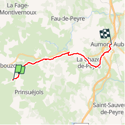
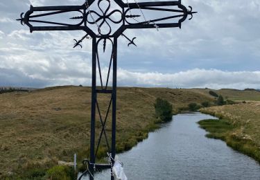
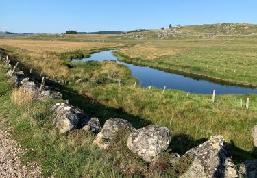
Trail Walking of 16.5 km to be discovered at Occitania, Lozère, Prinsuéjols-Malbouzon. This trail is proposed by tracegps.
Description
6ème et dernière étape de ce circuit. Finieyrols / Ferme des Gentianes - Aumont-Aubrac : 16,5 km. Nous poursuivons par le GR65 à l'encontre des pèlerins de St Jacques de Compostelle ! Nous retrouvons progressivement les paysages du début et nous apprécions les sous-bois bien frais...car il fait beau et chaud ! Voilà ! C'est fini... Belles randos à vous !!
Positioning
Comments
Trails nearby
![Trail Walking Prinsuéjols-Malbouzon - Prinsuejouls GR 65 - Photo](https://media.geolcdn.com/t/375/260/27679fa8-2676-42c2-9bc1-244f0333ecc6.jpg&format=jpg&maxdim=2)
![Walking Walking](https://static1.geolcdn.com/sitytour/trail-icons/101.png)
Walking
![](/images/other/stat-length.png)
![](https://static1.geolcdn.com/siteimages/upload/files/16400158638029165_repeat_loop_refresh_sync_direction_icon.png)
![Trail Walking Marchastel - Rieutort lac san andeol cascade deroc - Photo](https://media.geolcdn.com/t/375/260/33c320b5-cb8a-49f6-87c9-e02583e6c71a.jpg&format=jpg&maxdim=2)
![Walking Walking](https://static1.geolcdn.com/sitytour/trail-icons/101.png)
Walking
![](/images/other/stat-length.png)
![](https://static1.geolcdn.com/siteimages/upload/files/16400158638029165_repeat_loop_refresh_sync_direction_icon.png)
![Trail Walking Prinsuéjols-Malbouzon - Mon chemin de St Guilhem étape 2 - Photo](https://media.geolcdn.com/t/375/260/f65b24b5-3ed1-4a17-add2-d789cc20be07.jpg&format=jpg&maxdim=2)
![Walking Walking](https://static1.geolcdn.com/sitytour/trail-icons/101.png)
Walking
![](/images/other/stat-length.png)
![](https://static1.geolcdn.com/siteimages/upload/files/16400158638029165_repeat_loop_refresh_sync_direction_icon.png)
![Trail Walking Prinsuéjols-Malbouzon - Étape 2 Saint Gilhem - Photo](https://media.geolcdn.com/t/375/260/6632e795-50e4-46a6-bd0b-6f3a7d69c56f.jpg&format=jpg&maxdim=2)
![Walking Walking](https://static1.geolcdn.com/sitytour/trail-icons/101.png)
Walking
![](/images/other/stat-length.png)
![](https://static1.geolcdn.com/siteimages/upload/files/16400158638029165_repeat_loop_refresh_sync_direction_icon.png)
![Trail Walking Prinsuéjols-Malbouzon - Malbauzon - Photo](https://media.geolcdn.com/t/375/260/00d62d64-65d3-4102-9f24-7ece2435752b.jpg&format=jpg&maxdim=2)
![Walking Walking](https://static1.geolcdn.com/sitytour/trail-icons/101.png)
Walking
![](/images/other/stat-length.png)
![](https://static1.geolcdn.com/siteimages/upload/files/16400158638029165_repeat_loop_refresh_sync_direction_icon.png)
![Trail Walking Marchastel - Phot’Aubrac 2023 - Photo](https://media.geolcdn.com/t/375/260/bf4ad1f0-4880-4694-a7cf-d053c33db66e.jpg&format=jpg&maxdim=2)
![Walking Walking](https://static1.geolcdn.com/sitytour/trail-icons/101.png)
Walking
![](/images/other/stat-length.png)
![](https://static1.geolcdn.com/siteimages/upload/files/16400158638029165_repeat_loop_refresh_sync_direction_icon.png)
![Trail Walking Marchastel - Le Bes Rieutord Montgros variante - Photo](https://media.geolcdn.com/t/375/260/e8632685-678d-44bb-88ba-9c05548f987a.jpg&format=jpg&maxdim=2)
![Walking Walking](https://static1.geolcdn.com/sitytour/trail-icons/101.png)
Walking
![](/images/other/stat-length.png)
![](https://static1.geolcdn.com/siteimages/upload/files/16400158638029165_repeat_loop_refresh_sync_direction_icon.png)
![Trail On foot Marchastel - Marchastel - Lac Saint-Andéol - Photo](https://media.geolcdn.com/t/375/260/fcd2fa6e-1122-44d8-a1c9-27e2eb22d32c.jpeg&format=jpg&maxdim=2)
![On foot On foot](https://static1.geolcdn.com/sitytour/trail-icons/100.png)
On foot
![](/images/other/stat-length.png)
![](https://static1.geolcdn.com/siteimages/upload/files/16400158638029165_repeat_loop_refresh_sync_direction_icon.png)
![Trail Walking Prinsuéjols-Malbouzon - 2021 AUBRAC Étape 6 - Photo](https://media.geolcdn.com/t/375/260/847fb1d3-8256-4113-8cfd-2660f969252f.jpg&format=jpg&maxdim=2)
![Walking Walking](https://static1.geolcdn.com/sitytour/trail-icons/101.png)
Walking
![](/images/other/stat-length.png)
![](https://static1.geolcdn.com/siteimages/upload/files/16400158638029165_repeat_loop_refresh_sync_direction_icon.png)