![](/images/other/stat-length.png)
![Trail Walking Nasbinals - Tour des Monts d'Aubrac - De Nasbinals à la Ferme des Gentianes - Finieyrols - Photo](https://media.geolcdn.com/t/1900/400/ext.pjpeg?maxdim=2&url=https%3A%2F%2Fservices.sitytrail.com%2FGeolivesWS%2FDownloadMedia.ashx%3FTrailID%3D172693%26Media%3D14071_6.jpg)
Tour des Monts d'Aubrac - De Nasbinals à la Ferme des Gentianes - Finieyrols
tracegps
User
![Length](/images/other/stat-length.png)
Length
13.8 km
![Max alt](https://static1.geolcdn.com/siteimages/upload/files/1508320355ic_sort_altitude_max_24dp.png)
Max alt
1256 m
![Uphill gradient](https://static1.geolcdn.com/siteimages/upload/files/1508320355ic_sort_den_pos_24dp.png)
Uphill gradient
278 m
![Km-Effort](/images/other/stat-length.png)
Km-Effort
17.5 km
![Min alt](https://static1.geolcdn.com/siteimages/upload/files/1508320355ic_sort_altitude_min_24dp.png)
Min alt
1149 m
![Downhill gradient](https://static1.geolcdn.com/siteimages/upload/files/1508320355ic_sort_den_neg_24dp.png)
Downhill gradient
271 m
![Boucle](https://static1.geolcdn.com/siteimages/upload/files/16400158638029165_repeat_loop_refresh_sync_direction_icon.png)
Boucle
No
Creation date :
2014-12-10 00:00:00.0
Updated on :
2014-12-10 00:00:00.0
![Walking](https://static1.geolcdn.com/sitytour/trail-icons/101.png)
3h30
Difficulty : Medium
![Scan this QR Code to open this trail in the SityTrail application](https://capi.geolives.com/qq0zvz2zws4bq2lad0pu/sitytour/trails/172693/qr.png?size=200)
FREE GPS app for hiking
About
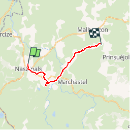
Trail Walking of 13.8 km to be discovered at Occitania, Lozère, Nasbinals. This trail is proposed by tracegps.
Description
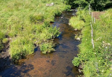
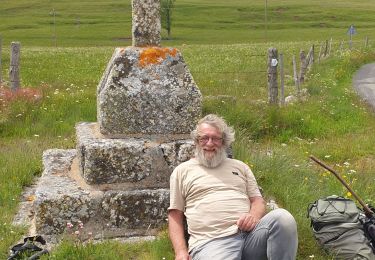
5ème étape de ce circuit qui en comporte 6. Nasbinals - cascade du Déroc - Ferme des Gentianes : 14 km. Etape repos ! Nous quittons Nasbinals par le Gr65 que nous quittons avant Montgros pour aller visiter la cascade puis long pique-nique au bord du Bès. Arrivée tranquille à la ferme des Gentianes.
Positioning
Country:
France
Region :
Occitania
Department/Province :
Lozère
Municipality :
Nasbinals
Location:
Unknown
Start:(Dec)
Start:(UTM)
503660 ; 4946015 (31T) N.
Comments
Trails nearby
![Trail Walking Marchastel - Rieutort lac san andeol cascade deroc - Photo](https://media.geolcdn.com/t/375/260/33c320b5-cb8a-49f6-87c9-e02583e6c71a.jpg&format=jpg&maxdim=2)
![Walking Walking](https://static1.geolcdn.com/sitytour/trail-icons/101.png)
Rieutort lac san andeol cascade deroc
Walking
Easy
(1)
Marchastel,
Occitania,
Lozère,
France
![](/images/other/stat-length.png)
17.5 km | 20 km-effort
4h 52min
![](https://static1.geolcdn.com/siteimages/upload/files/16400158638029165_repeat_loop_refresh_sync_direction_icon.png)
Yes
![Trail Walking Nasbinals - Nasbinals Montorzier Aubrac GR65 - Photo](https://media.geolcdn.com/t/375/260/1ac3a438-86b6-472c-99e2-7da904ac9db5.jpg&format=jpg&maxdim=2)
![Walking Walking](https://static1.geolcdn.com/sitytour/trail-icons/101.png)
Nasbinals Montorzier Aubrac GR65
Walking
Medium
Nasbinals,
Occitania,
Lozère,
France
![](/images/other/stat-length.png)
25 km | 31 km-effort
6h 28min
![](https://static1.geolcdn.com/siteimages/upload/files/16400158638029165_repeat_loop_refresh_sync_direction_icon.png)
Yes
![Trail On foot Nasbinals - chemin de Saint-Jacques-de-Compostelle pour randonneurs avec animaux (chien, ane, cheval) ou VTT - Photo](https://media.geolcdn.com/t/375/260/ce1c8375-c87d-45df-90e9-7235318ed55e.jpeg&format=jpg&maxdim=2)
![On foot On foot](https://static1.geolcdn.com/sitytour/trail-icons/100.png)
chemin de Saint-Jacques-de-Compostelle pour randonneurs avec animaux (chien, ...
On foot
Easy
Nasbinals,
Occitania,
Lozère,
France
![](/images/other/stat-length.png)
5.7 km | 7.3 km-effort
1h 38min
![](https://static1.geolcdn.com/siteimages/upload/files/16400158638029165_repeat_loop_refresh_sync_direction_icon.png)
No
![Trail Walking Saint-Urcize - St Urcize Carbonade Goutal Recoules - Photo](https://media.geolcdn.com/t/375/260/d5696f6e-bd72-472a-8c47-6bfe1d54378a.jpg&format=jpg&maxdim=2)
![Walking Walking](https://static1.geolcdn.com/sitytour/trail-icons/101.png)
St Urcize Carbonade Goutal Recoules
Walking
Easy
Saint-Urcize,
Auvergne-Rhône-Alpes,
Cantal,
France
![](/images/other/stat-length.png)
18.8 km | 24 km-effort
5h 7min
![](https://static1.geolcdn.com/siteimages/upload/files/16400158638029165_repeat_loop_refresh_sync_direction_icon.png)
Yes
![Trail Walking Recoules-d'Aubrac - Pont de Gourmier Grandval - Photo](https://media.geolcdn.com/t/375/260/ffa21da4-3882-4a5f-ba26-03b7d7246554.jpg&format=jpg&maxdim=2)
![Walking Walking](https://static1.geolcdn.com/sitytour/trail-icons/101.png)
Pont de Gourmier Grandval
Walking
Easy
Recoules-d'Aubrac,
Occitania,
Lozère,
France
![](/images/other/stat-length.png)
18.6 km | 23 km-effort
5h 19min
![](https://static1.geolcdn.com/siteimages/upload/files/16400158638029165_repeat_loop_refresh_sync_direction_icon.png)
Yes
![Trail Walking Saint-Urcize - St urcize - Photo](https://media.geolcdn.com/t/375/260/84e5b137-319d-4d6f-808d-85721d4634b7.jpg&format=jpg&maxdim=2)
![Walking Walking](https://static1.geolcdn.com/sitytour/trail-icons/101.png)
St urcize
Walking
Easy
Saint-Urcize,
Auvergne-Rhône-Alpes,
Cantal,
France
![](/images/other/stat-length.png)
16.4 km | 22 km-effort
5h 55min
![](https://static1.geolcdn.com/siteimages/upload/files/16400158638029165_repeat_loop_refresh_sync_direction_icon.png)
No
![Trail Walking Recoules-d'Aubrac - Au temps des fleurs et des genêts - Photo](https://media.geolcdn.com/t/375/260/5a185ad9-06d4-44d6-9906-03e9d4e1b2f0.jpg&format=jpg&maxdim=2)
![Walking Walking](https://static1.geolcdn.com/sitytour/trail-icons/101.png)
Au temps des fleurs et des genêts
Walking
Easy
Recoules-d'Aubrac,
Occitania,
Lozère,
France
![](/images/other/stat-length.png)
16.6 km | 21 km-effort
4h 24min
![](https://static1.geolcdn.com/siteimages/upload/files/16400158638029165_repeat_loop_refresh_sync_direction_icon.png)
Yes
![Trail Walking Nasbinals - Nasbinals - Photo](https://media.geolcdn.com/t/375/260/353c23b4-b06c-4ac9-9f3b-add84e5d6eb2.jpg&format=jpg&maxdim=2)
![Walking Walking](https://static1.geolcdn.com/sitytour/trail-icons/101.png)
![Trail sport Nasbinals - Nasbinal - Aubrac - Photo](https://media.geolcdn.com/t/375/260/ext.jpg?maxdim=2&url=https%3A%2F%2Fsecurestorage.geolives.com%2Fsitytour%2Ftrail-bg%2Fdefault.jpg)
Nasbinal - Aubrac
sport
Very easy
(1)
Nasbinals,
Occitania,
Lozère,
France
![](/images/other/stat-length.png)
42 km | 50 km-effort
Unknown
![](https://static1.geolcdn.com/siteimages/upload/files/16400158638029165_repeat_loop_refresh_sync_direction_icon.png)
No