![](/images/other/stat-length.png)
![Trail Walking Saint-Agnan-en-Vercors - À travers les Erges, point 1704 - Photo](https://media.geolcdn.com/t/1900/400/ext.pjpeg?maxdim=2&url=https%3A%2F%2Fservices.sitytrail.com%2FGeolivesWS%2FDownloadMedia.ashx%3FTrailID%3D172566%26Media%3D13934_1.jpg)
À travers les Erges, point 1704
tracegps
User
![Length](/images/other/stat-length.png)
![Max alt](https://static1.geolcdn.com/siteimages/upload/files/1508320355ic_sort_altitude_max_24dp.png)
![Uphill gradient](https://static1.geolcdn.com/siteimages/upload/files/1508320355ic_sort_den_pos_24dp.png)
![Km-Effort](/images/other/stat-length.png)
![Min alt](https://static1.geolcdn.com/siteimages/upload/files/1508320355ic_sort_altitude_min_24dp.png)
![Downhill gradient](https://static1.geolcdn.com/siteimages/upload/files/1508320355ic_sort_den_neg_24dp.png)
![Boucle](https://static1.geolcdn.com/siteimages/upload/files/16400158638029165_repeat_loop_refresh_sync_direction_icon.png)
![Walking](https://static1.geolcdn.com/sitytour/trail-icons/101.png)
5h00
Difficulty : Medium
![Scan this QR Code to open this trail in the SityTrail application](https://capi.geolives.com/qq0zvz2zws4bq2lad0pu/sitytour/trails/172566/qr.png?size=200)
FREE GPS app for hiking
About
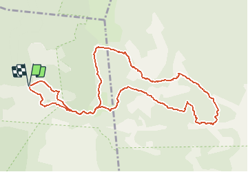
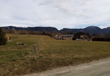
Trail Walking of 12.1 km to be discovered at Auvergne-Rhône-Alpes, Drôme, Saint-Agnan-en-Vercors. This trail is proposed by tracegps.
Description
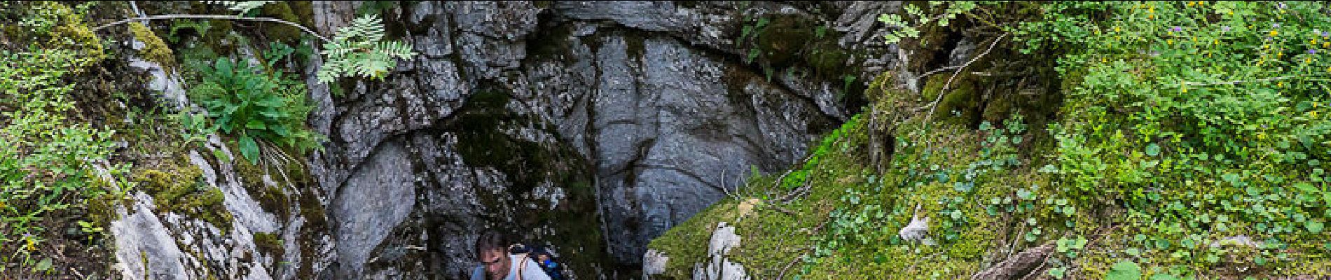
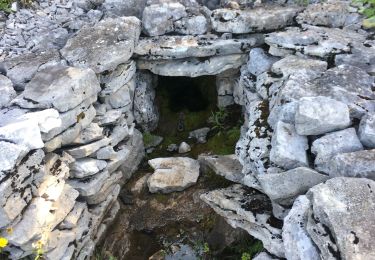
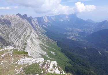
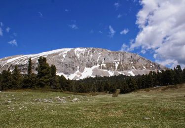
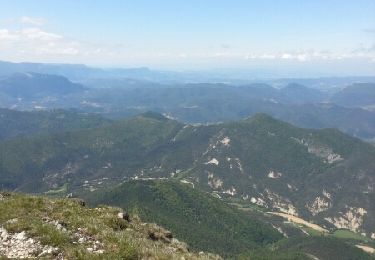
Une randonnée à travers les Erges, particulièrement sauvage après le Jas de la Plume, a permis la visite de plusieurs témoignages de l'activité charbonnière, intense sur ce secteur des plateaux du Vercors. Parfois à l'écart de l'itinéraire, plusieurs scialets et autres pots impressionnants, ont rappelé le considérable travail d'exploration des spéléos de l'APARV et de l'ASV. La direction générale de l'itinéraire orientée vers l'éminence 1704, passe par le cœur des Erges pour suivre un talweg bien marqué. Après un crochet vers le Nord, la traversé du versant Sud du point 1704 permettra de retrouver la Draye des Bergers. La quittant vers 1480 m, l'amont de la combe de juin 2011, permet de trouver une vieille sente dans la direction du Sud d'Arbounouse. Le GR91 retrouvé, ramène vers le Pot du Play et le Col de la Berche, le point de départ. Description complète sur sentier-nature.com : À travers les Erges, point 1704 Avertissement [Orientation 3/3 ; Pénibilité 1/3]. Certains passages de cet itinéraire de montagne sont escarpés et/ou très exposés, il est déconseillé aux enfants non accompagnés et aux personnes sujettes au vertige. Pour votre sécurité, nous vous invitons à respecter les règles suivantes : être bien chaussé, ne pas s'engager par mauvais temps, ne pas s'écarter de l'itinéraire ni des sentiers. Cet itinéraire ce déroule tout ou partie dans la Réserve Naturelle des Hauts Plateaux du Vercors qui a pour mission d'étudier et de gérer ce territoire afin que les diverses activités qui s'y exercent (élevage, exploitation forestière, randonnée, etc.) soient compatibles avec la préservation de la faune, de la flore et du paysage. Participez à la protection de cet espace en respectant la réglementation.
Positioning
Comments
Trails nearby
![Trail Walking La Chapelle-en-Vercors - Belvedere de la Révoulat - Photo](https://media.geolcdn.com/t/375/260/ext.jpg?maxdim=2&url=https%3A%2F%2Fservices.sitytrail.com%2FGeolivesWS%2FDownloadMedia.ashx%3FTrailID%3D190649%26Media%3Dbea7fca0-eae7-4bcb-a9b2-0754c6f93b9f.JPG)
![Walking Walking](https://static1.geolcdn.com/sitytour/trail-icons/101.png)
Walking
![](/images/other/stat-length.png)
![](https://static1.geolcdn.com/siteimages/upload/files/16400158638029165_repeat_loop_refresh_sync_direction_icon.png)
![Trail Walking Saint-Agnan-en-Vercors - 26 tiolache - Photo](https://media.geolcdn.com/t/375/260/901b344f-b319-4266-9f0a-69075395b314.jpg&format=jpg&maxdim=2)
![Walking Walking](https://static1.geolcdn.com/sitytour/trail-icons/101.png)
Walking
![](/images/other/stat-length.png)
![](https://static1.geolcdn.com/siteimages/upload/files/16400158638029165_repeat_loop_refresh_sync_direction_icon.png)
![Trail Walking Saint-Agnan-en-Vercors - 26 st Agnan champ gros de la vache - Photo](https://media.geolcdn.com/t/375/260/3e876886-71b3-45d3-bba1-ada65af3bf18.jpg&format=jpg&maxdim=2)
![Walking Walking](https://static1.geolcdn.com/sitytour/trail-icons/101.png)
Walking
![](/images/other/stat-length.png)
![](https://static1.geolcdn.com/siteimages/upload/files/16400158638029165_repeat_loop_refresh_sync_direction_icon.png)
![Trail Walking Saint-Agnan-en-Vercors - Malaval - Photo](https://media.geolcdn.com/t/375/260/39c0c415-627d-42e7-b9a5-65769dc8255c.jpg&format=jpg&maxdim=2)
![Walking Walking](https://static1.geolcdn.com/sitytour/trail-icons/101.png)
Walking
![](/images/other/stat-length.png)
![](https://static1.geolcdn.com/siteimages/upload/files/16400158638029165_repeat_loop_refresh_sync_direction_icon.png)
![Trail Walking La Chapelle-en-Vercors - La Chapelle en Vercors - Vassieux (Première étape balade ânes) - Photo](https://media.geolcdn.com/t/375/260/b49bd35a-4f2e-4f1b-8661-fc564460d7b5.jpg&format=jpg&maxdim=2)
![Walking Walking](https://static1.geolcdn.com/sitytour/trail-icons/101.png)
Walking
![](/images/other/stat-length.png)
![](https://static1.geolcdn.com/siteimages/upload/files/16400158638029165_repeat_loop_refresh_sync_direction_icon.png)
![Trail Walking La Chapelle-en-Vercors - Le tour de la Chapelle en Vercors - Photo](https://media.geolcdn.com/t/375/260/e1825710-d5d4-4e77-b775-d1023e4c1e57.jpg&format=jpg&maxdim=2)
![Walking Walking](https://static1.geolcdn.com/sitytour/trail-icons/101.png)
Walking
![](/images/other/stat-length.png)
![](https://static1.geolcdn.com/siteimages/upload/files/16400158638029165_repeat_loop_refresh_sync_direction_icon.png)
![Trail Walking Saint-Agnan-en-Vercors - Seguret - Photo](https://media.geolcdn.com/t/375/260/92d4223c-759d-4f55-a478-bffef67a4884.jpg&format=jpg&maxdim=2)
![Walking Walking](https://static1.geolcdn.com/sitytour/trail-icons/101.png)
Walking
![](/images/other/stat-length.png)
![](https://static1.geolcdn.com/siteimages/upload/files/16400158638029165_repeat_loop_refresh_sync_direction_icon.png)
![Trail Walking Saint-Andéol - Les Hauts Plateaux du Vercors en âne - Etape 2 - Photo](https://media.geolcdn.com/t/375/260/ext.jpg?maxdim=2&url=https%3A%2F%2Fservices.sitytrail.com%2FGeolivesWS%2FDownloadMedia.ashx%3FTrailID%3D317955%26Media%3D17392_6.jpg)
![Walking Walking](https://static1.geolcdn.com/sitytour/trail-icons/101.png)
Walking
![](/images/other/stat-length.png)
![](https://static1.geolcdn.com/siteimages/upload/files/16400158638029165_repeat_loop_refresh_sync_direction_icon.png)
![Trail Walking La Chapelle-en-Vercors - tour du Vercors en 3 jours - Photo](https://media.geolcdn.com/t/375/260/ext.jpg?maxdim=2&url=https%3A%2F%2Fservices.sitytrail.com%2FGeolivesWS%2FDownloadMedia.ashx%3FTrailID%3D307775%26Media%3Dfix__20140530121133.jpg)
![Walking Walking](https://static1.geolcdn.com/sitytour/trail-icons/101.png)
Walking
![](/images/other/stat-length.png)
![](https://static1.geolcdn.com/siteimages/upload/files/16400158638029165_repeat_loop_refresh_sync_direction_icon.png)