Trail Walking Névache - Lac Laramon et Lac du Serpent - Névache - Photo

Lac Laramon et Lac du Serpent - Névache

 tracegps
tracegps

User

© OpenStreetMap contributors
Length
Length
15 km
Max alt
Max alt
2457 m
Uphill gradient
Uphill gradient
765 m
Km-Effort
Km-Effort  
25 km
Min alt
Min alt
1744 m
Downhill gradient
Downhill gradient
766 m
Boucle
Boucle
Yes
Creation date :
2014-12-10 00:00:00.0
Updated on :
2014-12-10 00:00:00.0

(0 Reviews)

Walking
Walking
5h00
Difficulty : Difficult

Scan this QR Code to open this trail in the SityTrail application

FREE GPS app for hiking

Logo SityTrail SityTrail

IGN / Geographical institutes

Download SityTrail from the App Store Download SityTrail from Google Play

Logo SityTrail SityTrail World

The world is yours!

Download SityTrail from the App Store Download SityTrail from Google Play Download SityTrail on Huawei AppGallery

About

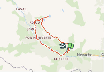
Trail Walking of 15 km to be discovered at Provence-Alpes-Côte d'Azur, Hautes-Alpes, Névache. This trail is proposed by tracegps.

Description

Une randonnée incontournable a partir de Névache. Au départ du pont de Rately, rejoindre la piste et prendre le GR pour atteindre, au bout d'une heure et 300 mètres de dénivelé, le GR "Tour du Mont Thabor" qui surplombe la vallée. Le prendre à gauche afin d'atteindre l'embranchement vers les lacs. Le retour s'effectue par le refuge de Ricou, les Chalets de Fontcouverte et le sentier qui longe la Clarée.

Elevation profile

Photos

Positioning

Country:
France
Region :
Provence-Alpes-Côte d'Azur
Department/Province :
Hautes-Alpes
Municipality :
Névache
Location:
Unknown
Start:(UTM)
309560 ; 4988148 (32T) N.

Trails nearby

Trail Walking Névache - Briançonnais Lac du Serpent - Photo
Walking
GUIDE
Orcal37

Walking

Medium
(2)
Névache, Provence-Alpes-Côte d'Azur, Hautes-Alpes, France
10 km | 18 km-effort
3h 10min
Yes
Trail Walking Névache - Col du Chardonnet - Névache - Photo
Walking
tracegps

Walking

Medium
(3)
Névache, Provence-Alpes-Côte d'Azur, Hautes-Alpes, France
12.3 km | 23 km-effort
4h 0min
Yes
Trail Walking Névache - Via Alpina - R127: Névache > Le Monêtier-les-Bains - Photo
Walking
tracegps

Walking

Difficult
(1)
Névache, Provence-Alpes-Côte d'Azur, Hautes-Alpes, France
15.5 km | 28 km-effort
5h 0min
No
Trail Walking Névache - Beraudes  - Photo
Walking
GUIDE
jouans

Walking

Medium
Névache, Provence-Alpes-Côte d'Azur, Hautes-Alpes, France
11.1 km | 22 km-effort
6h 33min
No
Trail Walking Névache - Gardiette  - Photo
Walking
GUIDE
jouans

Walking

Easy
Névache, Provence-Alpes-Côte d'Azur, Hautes-Alpes, France
16.6 km | 32 km-effort
7h 33min
Yes
Trail Walking Névache - Col roche noire  - Photo
Walking
GUIDE
jouans

Walking

Difficult
Névache, Provence-Alpes-Côte d'Azur, Hautes-Alpes, France
17.1 km | 31 km-effort
6h 37min
Yes
Trail Walking Névache - la roche du Chardonnet - Photo
Walking
GUIDE
amiral13

Walking

Medium
Névache, Provence-Alpes-Côte d'Azur, Hautes-Alpes, France
16.6 km | 29 km-effort
7h 26min
Yes
Trail Walking Névache - Lacs Laramon et Serpent - Photo
Walking
neoroll44

Walking

Medium
(2)
Névache, Provence-Alpes-Côte d'Azur, Hautes-Alpes, France
10.4 km | 21 km-effort
6h 0min
Yes
Trail Other activity Névache - Pointe des Cerces . Circuit du lac rouge - Photo
Other activity
GUIDE
nadd73

Other activity

Difficult
Névache, Provence-Alpes-Côte d'Azur, Hautes-Alpes, France
13.5 km | 32 km-effort
7h 53min
Yes


Close
My subscriptions