![](/images/other/stat-length.png)
![Trail Walking Barèges - Le Turon de Néouvielle - Photo](https://media.geolcdn.com/t/1900/400/ext.pjpeg?maxdim=2&url=https%3A%2F%2Fservices.sitytrail.com%2FGeolivesWS%2FDownloadMedia.ashx%3FTrailID%3D172478%26Media%3D13834_6.jpg)
Le Turon de Néouvielle
tracegps
User
![Length](/images/other/stat-length.png)
![Max alt](https://static1.geolcdn.com/siteimages/upload/files/1508320355ic_sort_altitude_max_24dp.png)
![Uphill gradient](https://static1.geolcdn.com/siteimages/upload/files/1508320355ic_sort_den_pos_24dp.png)
![Km-Effort](/images/other/stat-length.png)
![Min alt](https://static1.geolcdn.com/siteimages/upload/files/1508320355ic_sort_altitude_min_24dp.png)
![Downhill gradient](https://static1.geolcdn.com/siteimages/upload/files/1508320355ic_sort_den_neg_24dp.png)
![Boucle](https://static1.geolcdn.com/siteimages/upload/files/16400158638029165_repeat_loop_refresh_sync_direction_icon.png)
![Walking](https://static1.geolcdn.com/sitytour/trail-icons/101.png)
11h00
Difficulty : Difficult
![Scan this QR Code to open this trail in the SityTrail application](https://capi.geolives.com/qq0zvz2zws4bq2lad0pu/sitytour/trails/172478/qr.png?size=200)
FREE GPS app for hiking
About
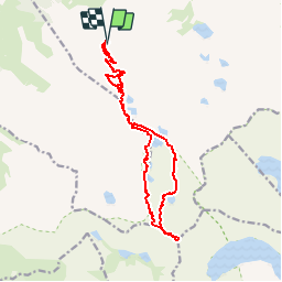
Trail Walking of 17.1 km to be discovered at Occitania, Hautespyrenees, Barèges. This trail is proposed by tracegps.
Description
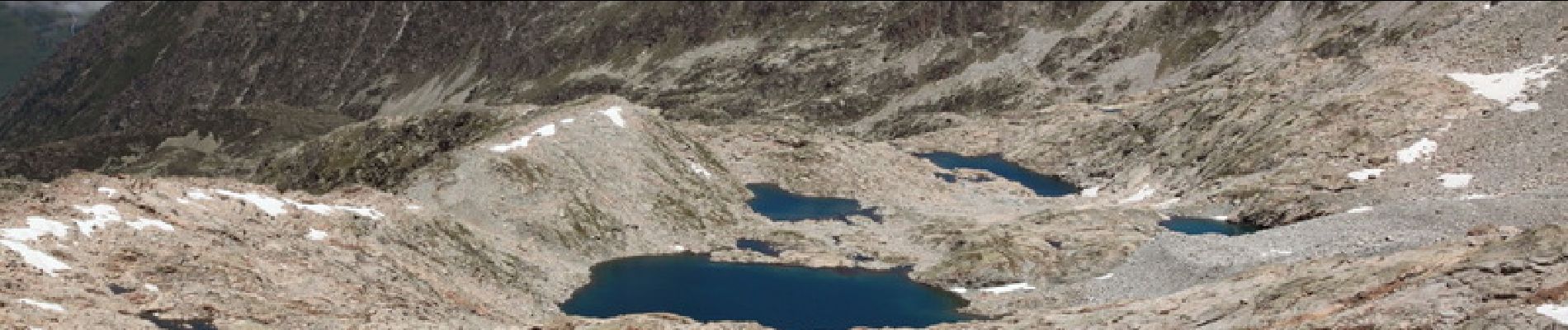
Cette randonnée vers le Turon du Néouvielle permet de longer un nombre impressionnant de lacs différents à l’aller (par les lacs d’Estrelat) comme au retour (par les lacs de Maniportet). Depuis le sommet à 3035m, on découvre un panorama exceptionnel comprenant notamment le Campbieil, le Pic Long (le sommet du massif du Néouvielle), le Marbore, la brèche de Roland, le Taillon, le Vignemale, le Balaitous, le Pic du Midi de Bigorre, le pic de Néouvielle... Au-dessus de 2450m, le cheminement se fait majoritairement sur des rochers ou blocs de différentes tailles et la progression n’est donc pas très rapide. A noter qu’un départ depuis le refuge de la Glère réduit le dénivelé positif de près de 500m.
Positioning
Comments
Trails nearby
![Trail Walking Barèges - Pic des Trois Conseillers - Photo](https://media.geolcdn.com/t/375/260/ext.jpg?maxdim=2&url=https%3A%2F%2Fservices.sitytrail.com%2FGeolivesWS%2FDownloadMedia.ashx%3FTrailID%3D172698%26Media%3D14081_6.jpg)
![Walking Walking](https://static1.geolcdn.com/sitytour/trail-icons/101.png)
Walking
![](/images/other/stat-length.png)
![](https://static1.geolcdn.com/siteimages/upload/files/16400158638029165_repeat_loop_refresh_sync_direction_icon.png)
![Trail Walking Barèges - Pic de Madamète en boucle par les lacs - Photo](https://media.geolcdn.com/t/375/260/ext.jpg?maxdim=2&url=https%3A%2F%2Fservices.sitytrail.com%2FGeolivesWS%2FDownloadMedia.ashx%3FTrailID%3D107077%26Media%3D11899_5.jpg)
![Walking Walking](https://static1.geolcdn.com/sitytour/trail-icons/101.png)
Walking
![](/images/other/stat-length.png)
![](https://static1.geolcdn.com/siteimages/upload/files/16400158638029165_repeat_loop_refresh_sync_direction_icon.png)
![Trail Horseback riding Sers - Plateau d’Aoube par la cabane d’Aoube - Photo](https://media.geolcdn.com/t/375/260/d0a193ac-ccc5-435d-ab72-b3f01c20ee9b.jpg&format=jpg&maxdim=2)
![Horseback riding Horseback riding](https://static1.geolcdn.com/sitytour/trail-icons/301.png)
Horseback riding
![](/images/other/stat-length.png)
![](https://static1.geolcdn.com/siteimages/upload/files/16400158638029165_repeat_loop_refresh_sync_direction_icon.png)
![Trail Walking Barèges - BAREGES le tour des plateaux G4 reco 3264577 - Photo](https://media.geolcdn.com/t/375/260/d3369853-4ed9-48c9-b0c7-23b9f6db24d3.jpg&format=jpg&maxdim=2)
![Walking Walking](https://static1.geolcdn.com/sitytour/trail-icons/101.png)
Walking
![](/images/other/stat-length.png)
![](https://static1.geolcdn.com/siteimages/upload/files/16400158638029165_repeat_loop_refresh_sync_direction_icon.png)
![Trail Walking Bagnères-de-Bigorre - tourmalet G2 heit - Photo](https://media.geolcdn.com/t/375/260/8cd371a0-9f70-473d-b4f9-0ddefaeeb150.jpg&format=jpg&maxdim=2)
![Walking Walking](https://static1.geolcdn.com/sitytour/trail-icons/101.png)
Walking
![](/images/other/stat-length.png)
![](https://static1.geolcdn.com/siteimages/upload/files/16400158638029165_repeat_loop_refresh_sync_direction_icon.png)
![Trail Walking Barèges - En boucle, Grand Tourmalet- Aygues Cluses-Col de Madamète- Lac Dets Coubous. - Photo](https://media.geolcdn.com/t/375/260/ext.jpg?maxdim=2&url=https%3A%2F%2Fstatic1.geolcdn.com%2Fsiteimages%2Fupload%2Ffiles%2F1553511878bg_sport_marche.png)
![Walking Walking](https://static1.geolcdn.com/sitytour/trail-icons/101.png)
Walking
![](/images/other/stat-length.png)
![](https://static1.geolcdn.com/siteimages/upload/files/16400158638029165_repeat_loop_refresh_sync_direction_icon.png)
![Trail Walking Barèges - Bareges St Justin - Photo](https://media.geolcdn.com/t/375/260/1c3cf81f-9908-4ac1-bcb6-4709b37a0797.jpg&format=jpg&maxdim=2)
![Walking Walking](https://static1.geolcdn.com/sitytour/trail-icons/101.png)
Walking
![](/images/other/stat-length.png)
![](https://static1.geolcdn.com/siteimages/upload/files/16400158638029165_repeat_loop_refresh_sync_direction_icon.png)
![Trail Walking Betpouey - Betpouey - Photo](https://media.geolcdn.com/t/375/260/de97bd3a-02fa-40ea-9373-8508fc6f8d96.jpg&format=jpg&maxdim=2)
![Walking Walking](https://static1.geolcdn.com/sitytour/trail-icons/101.png)
Walking
![](/images/other/stat-length.png)
![](https://static1.geolcdn.com/siteimages/upload/files/16400158638029165_repeat_loop_refresh_sync_direction_icon.png)
![Trail Walking Sers - BAREGES G4 le tour des plateaux](https://media.geolcdn.com/t/375/260/3b1a88cc-7c19-44dc-b1bc-bd751409e5bf.jpg&format=jpg&maxdim=2)
![Walking Walking](https://static1.geolcdn.com/sitytour/trail-icons/101.png)
Walking
![](/images/other/stat-length.png)
![](https://static1.geolcdn.com/siteimages/upload/files/16400158638029165_repeat_loop_refresh_sync_direction_icon.png)