![](/images/other/stat-length.png)
![Trail Walking Monnetier-Mornex - Salève, circuit par la vire de la Corraterie - Photo](https://media.geolcdn.com/t/1900/400/ext.pjpeg?maxdim=2&url=https%3A%2F%2Fservices.sitytrail.com%2FGeolivesWS%2FDownloadMedia.ashx%3FTrailID%3D172408%26Media%3D13754_1.jpg)
Salève, circuit par la vire de la Corraterie
tracegps
User
![Length](/images/other/stat-length.png)
![Max alt](https://static1.geolcdn.com/siteimages/upload/files/1508320355ic_sort_altitude_max_24dp.png)
![Uphill gradient](https://static1.geolcdn.com/siteimages/upload/files/1508320355ic_sort_den_pos_24dp.png)
![Km-Effort](/images/other/stat-length.png)
![Min alt](https://static1.geolcdn.com/siteimages/upload/files/1508320355ic_sort_altitude_min_24dp.png)
![Downhill gradient](https://static1.geolcdn.com/siteimages/upload/files/1508320355ic_sort_den_neg_24dp.png)
![Boucle](https://static1.geolcdn.com/siteimages/upload/files/16400158638029165_repeat_loop_refresh_sync_direction_icon.png)
![Walking](https://static1.geolcdn.com/sitytour/trail-icons/101.png)
3h30
Difficulty : Medium
![Scan this QR Code to open this trail in the SityTrail application](https://capi.geolives.com/qq0zvz2zws4bq2lad0pu/sitytour/trails/172408/qr.png?size=200)
FREE GPS app for hiking
About
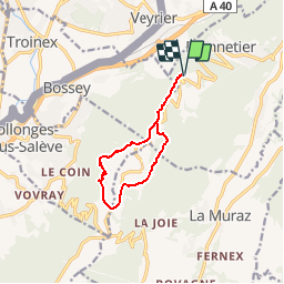
Trail Walking of 9.6 km to be discovered at Auvergne-Rhône-Alpes, Upper Savoy, Monnetier-Mornex. This trail is proposed by tracegps.
Description
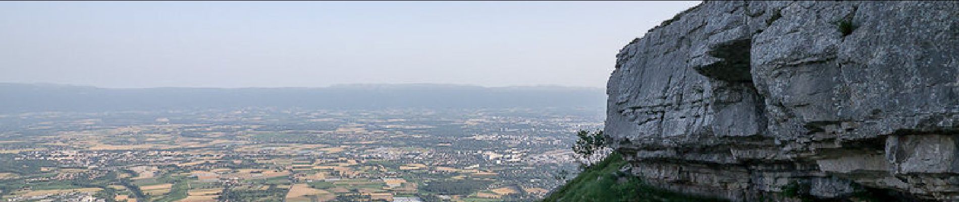
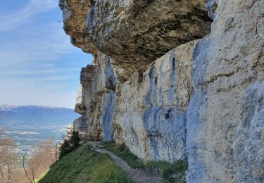
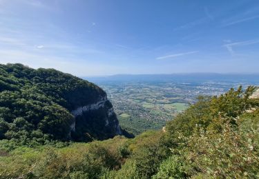
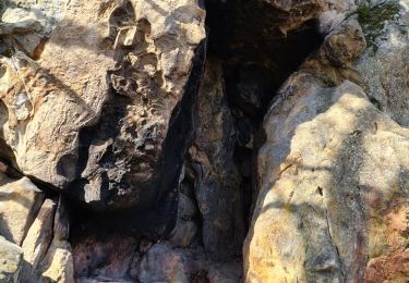
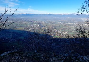
Salève. Depuis la gare supérieure du téléférique, l'itinéraire monte traverser le plateau du Salève, en passant par l'ancienne table d'orientation des Treize Arbres. En suivant le bord des escarpements, l'à pic des falaises réserve un point de vue saisissant sur Genève et le Lac Léman. Bientôt en lisière du bois, le sentier conduit à la grande vire de la Corraterie qui offre une magnifique traversée en encorbellement. Passant par le curieux Trou de la Tine, la randonnée se poursuit par la Bouillette. À l'écart du parcours, la visite de la Grotte d'Orjobet est incontournable. Le retour par les Crêts passe par la ferme de la Pile et la Grange Gaby. Le plateau du Salève rejoint, l'itinéraire emprunté à l'aller ramène au point de départ. Description complète sur sentier-nature.com : Salève, circuit par la vire de la Corraterie Avertissement [Exposition 1/3]. Certains passages de cet itinéraire de montagne sont escarpés et/ou très exposés, il est déconseillé aux enfants non accompagnés et aux personnes sujettes au vertige. Pour votre sécurité, nous vous invitons à respecter les règles suivantes : être bien chaussé, ne pas s'engager par mauvais temps, ne pas s'écarter de l'itinéraire ni des sentiers.
Positioning
Comments
Trails nearby
![Trail On foot Carouge (GE) - De Staël - Place Verte - Photo](https://media.geolcdn.com/t/375/260/097d8cc8-85e9-4d02-9d1d-72c864b74792.jpeg&format=jpg&maxdim=2)
![On foot On foot](https://static1.geolcdn.com/sitytour/trail-icons/100.png)
On foot
![](/images/other/stat-length.png)
![](https://static1.geolcdn.com/siteimages/upload/files/16400158638029165_repeat_loop_refresh_sync_direction_icon.png)
![Trail On foot Veyrier - Eaux d'Arve - Pinchat - Photo](https://media.geolcdn.com/t/375/260/01df3976-cbc6-4733-8377-6a29e56e0add.jpeg&format=jpg&maxdim=2)
![On foot On foot](https://static1.geolcdn.com/sitytour/trail-icons/100.png)
On foot
![](/images/other/stat-length.png)
![](https://static1.geolcdn.com/siteimages/upload/files/16400158638029165_repeat_loop_refresh_sync_direction_icon.png)
![Trail Walking Collonges-sous-Salève - Le Coin-Grottes d'Orjobet-La Corraterie-Grande Gorge-Le Coin - Photo](https://media.geolcdn.com/t/375/260/aabf5e02-cc0c-4aa0-939a-41b03f824e1c.jpg&format=jpg&maxdim=2)
![Walking Walking](https://static1.geolcdn.com/sitytour/trail-icons/101.png)
Walking
![](/images/other/stat-length.png)
![](https://static1.geolcdn.com/siteimages/upload/files/16400158638029165_repeat_loop_refresh_sync_direction_icon.png)
![Trail Walking Étrembières - Château Etrembières-Les Voûtes-Salève Observatoire - Photo](https://media.geolcdn.com/t/375/260/015a4621-3968-42ed-9ea3-83173bd5ccbc.jpg&format=jpg&maxdim=2)
![Walking Walking](https://static1.geolcdn.com/sitytour/trail-icons/101.png)
Walking
![](/images/other/stat-length.png)
![](https://static1.geolcdn.com/siteimages/upload/files/16400158638029165_repeat_loop_refresh_sync_direction_icon.png)
![Trail Walking La Muraz - La Croisette - Téléphérique - Photo](https://media.geolcdn.com/t/375/260/bbb7530c-646b-4278-a608-5976a2ccf5a8.jpg&format=jpg&maxdim=2)
![Walking Walking](https://static1.geolcdn.com/sitytour/trail-icons/101.png)
Walking
![](/images/other/stat-length.png)
![](https://static1.geolcdn.com/siteimages/upload/files/16400158638029165_repeat_loop_refresh_sync_direction_icon.png)
![Trail Walking Monnetier-Mornex - sentier de la Sauge - Photo](https://media.geolcdn.com/t/375/260/c35518be-b219-456a-b639-b0d81d9789ec.jpg&format=jpg&maxdim=2)
![Walking Walking](https://static1.geolcdn.com/sitytour/trail-icons/101.png)
Walking
![](/images/other/stat-length.png)
![](https://static1.geolcdn.com/siteimages/upload/files/16400158638029165_repeat_loop_refresh_sync_direction_icon.png)
![Trail Walking Collonges-sous-Salève - Le Salève en boucle, orjobet , corraterie, belvédère, grande gorge - Photo](https://media.geolcdn.com/t/375/260/201bd548-abfc-4c16-8a26-ab36aa21dc20.jpg&format=jpg&maxdim=2)
![Walking Walking](https://static1.geolcdn.com/sitytour/trail-icons/101.png)
Walking
![](/images/other/stat-length.png)
![](https://static1.geolcdn.com/siteimages/upload/files/16400158638029165_repeat_loop_refresh_sync_direction_icon.png)
![Trail Walking Collonges-sous-Salève - SALEVE - Photo](https://media.geolcdn.com/t/375/260/7cbc3f40-5ee2-427e-bcb6-ff3543321705.jpg&format=jpg&maxdim=2)
![Walking Walking](https://static1.geolcdn.com/sitytour/trail-icons/101.png)
Walking
![](/images/other/stat-length.png)
![](https://static1.geolcdn.com/siteimages/upload/files/16400158638029165_repeat_loop_refresh_sync_direction_icon.png)
![Trail Walking Collonges-sous-Salève - GRAND SALEVE: GROTTES ET SENTIER-BALCON - Photo](https://media.geolcdn.com/t/375/260/254bcac5-a0fe-43c3-a1c2-202e25644106.jpg&format=jpg&maxdim=2)
![Walking Walking](https://static1.geolcdn.com/sitytour/trail-icons/101.png)
Walking
![](/images/other/stat-length.png)
![](https://static1.geolcdn.com/siteimages/upload/files/16400158638029165_repeat_loop_refresh_sync_direction_icon.png)
Faite le 29/12/2022, très belle balade avec des vues superbes sur Genève et sur le Mont-Blanc.
rando facile pour qui ne craint pas le vide. Vues magnifiques sur le lac Leman et les Alpes.