![](/images/other/stat-length.png)
![Trail Mountain bike Bezins-Garraux - Autour du Mourtis - Bezins Garraux - Photo](https://media.geolcdn.com/t/1900/400/ext.pjpeg?maxdim=2&url=https%3A%2F%2Fstatic1.geolcdn.com%2Fsiteimages%2Fupload%2Ffiles%2F1524743154velo.jpg)
Autour du Mourtis - Bezins Garraux
tracegps
User
![Length](/images/other/stat-length.png)
![Max alt](https://static1.geolcdn.com/siteimages/upload/files/1508320355ic_sort_altitude_max_24dp.png)
![Uphill gradient](https://static1.geolcdn.com/siteimages/upload/files/1508320355ic_sort_den_pos_24dp.png)
![Km-Effort](/images/other/stat-length.png)
![Min alt](https://static1.geolcdn.com/siteimages/upload/files/1508320355ic_sort_altitude_min_24dp.png)
![Downhill gradient](https://static1.geolcdn.com/siteimages/upload/files/1508320355ic_sort_den_neg_24dp.png)
![Boucle](https://static1.geolcdn.com/siteimages/upload/files/16400158638029165_repeat_loop_refresh_sync_direction_icon.png)
![Mountain bike](https://static1.geolcdn.com/sitytour/trail-icons/202.png)
3h00
Difficulty : Difficult
![Scan this QR Code to open this trail in the SityTrail application](https://capi.geolives.com/qq0zvz2zws4bq2lad0pu/sitytour/trails/172404/qr.png?size=200)
FREE GPS app for hiking
About
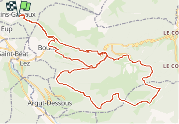
Trail Mountain bike of 32 km to be discovered at Occitania, Haute-Garonne, Bezins-Garraux. This trail is proposed by tracegps.
Description
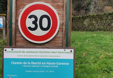
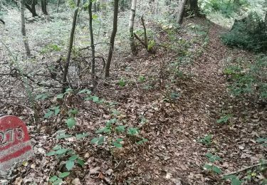
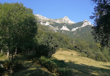
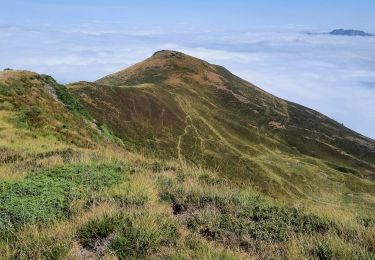
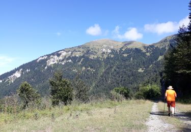
Très beau circuit autour de la station du Mourtis. Le départ se fait sur un chemin forestier facile et agréable. Rapidement, nous rejoignons la route du col de Menté pour environ 3km5 sur la route. Ensuite, nous empruntons une piste forestière qui nous permet de faire le tour complet des deux sommets qui surplombent la station avec un très beau passage sur une mono-trace dans une hêtraie centenaire. Une fois arrivée à la station, la partie difficile commence vraiment car pour redescendre à la voiture, nous utilisons la descente vtt qui servait avant aux compétitions de DH: très bon niveau en descente exigé! Le final se fait par la même piste qu'à l'allée.
Positioning
Comments
Trails nearby
![Trail Running Juzet-d'Izaut - TRAIL-Cagire - Photo](https://media.geolcdn.com/t/375/260/ext.jpg?maxdim=2&url=https%3A%2F%2Fstatic1.geolcdn.com%2Fsiteimages%2Fupload%2Ffiles%2F1524743154running.jpg)
![Running Running](https://static1.geolcdn.com/sitytour/trail-icons/103.png)
Running
![](/images/other/stat-length.png)
![](https://static1.geolcdn.com/siteimages/upload/files/16400158638029165_repeat_loop_refresh_sync_direction_icon.png)
![Trail On foot Juzet-d'Izaut - Voie du Piémont, Saint-Lizier - Saint-Bertrand-de-Comminges - Photo](https://media.geolcdn.com/t/375/260/3ae75a35-bd03-4436-8469-3713e4a4a607.jpeg&format=jpg&maxdim=2)
![On foot On foot](https://static1.geolcdn.com/sitytour/trail-icons/100.png)
On foot
![](/images/other/stat-length.png)
![](https://static1.geolcdn.com/siteimages/upload/files/16400158638029165_repeat_loop_refresh_sync_direction_icon.png)
![Trail Running Bezins-Garraux - Pic du Gar - Bezins - Photo](https://media.geolcdn.com/t/375/260/ext.jpg?maxdim=2&url=https%3A%2F%2Fservices.sitytrail.com%2FGeolivesWS%2FDownloadMedia.ashx%3FTrailID%3D215037%26Media%3D15605_6.jpg)
![Running Running](https://static1.geolcdn.com/sitytour/trail-icons/103.png)
Running
![](/images/other/stat-length.png)
![](https://static1.geolcdn.com/siteimages/upload/files/16400158638029165_repeat_loop_refresh_sync_direction_icon.png)
![Trail Walking Bezins-Garraux - Rando Pic du Gar - Photo](https://media.geolcdn.com/t/375/260/7334aa4e-c31d-4425-9416-b35a7b5153c2.jpg&format=jpg&maxdim=2)
![Walking Walking](https://static1.geolcdn.com/sitytour/trail-icons/101.png)
Walking
![](/images/other/stat-length.png)
![](https://static1.geolcdn.com/siteimages/upload/files/16400158638029165_repeat_loop_refresh_sync_direction_icon.png)
![Trail Walking Marignac - Départ Marignac, Mail blanc +furifere chemin de la liberté Eco Rando jeudi - Photo](https://media.geolcdn.com/t/375/260/eb34fd21-d630-4b7a-8b4d-c968dca07ec2.jpg&format=jpg&maxdim=2)
![Walking Walking](https://static1.geolcdn.com/sitytour/trail-icons/101.png)
Walking
![](/images/other/stat-length.png)
![](https://static1.geolcdn.com/siteimages/upload/files/16400158638029165_repeat_loop_refresh_sync_direction_icon.png)
![Trail Walking Chaum - SityTrail - GR86new - Photo](https://media.geolcdn.com/t/375/260/530158b7-46f5-4fcd-b151-0997ad9f9b33.jpg&format=jpg&maxdim=2)
![Walking Walking](https://static1.geolcdn.com/sitytour/trail-icons/101.png)
Walking
![](/images/other/stat-length.png)
![](https://static1.geolcdn.com/siteimages/upload/files/16400158638029165_repeat_loop_refresh_sync_direction_icon.png)
![Trail Walking Boutx - SityTrail - GR86new - Photo](https://media.geolcdn.com/t/375/260/5adde373-4d8e-4fc0-8e30-4ab63b54b94e.jpg&format=jpg&maxdim=2)
![Walking Walking](https://static1.geolcdn.com/sitytour/trail-icons/101.png)
Walking
![](/images/other/stat-length.png)
![](https://static1.geolcdn.com/siteimages/upload/files/16400158638029165_repeat_loop_refresh_sync_direction_icon.png)
![Trail Walking Marignac - pic du Burat depuis Marignac à Gouaux de Luchon - Photo](https://media.geolcdn.com/t/375/260/323b189f-6f6f-4b9a-ab43-ae0dcdbdfb8f.jpg&format=jpg&maxdim=2)
![Walking Walking](https://static1.geolcdn.com/sitytour/trail-icons/101.png)
Walking
![](/images/other/stat-length.png)
![](https://static1.geolcdn.com/siteimages/upload/files/16400158638029165_repeat_loop_refresh_sync_direction_icon.png)
![Trail Walking Boutx - la couage col de combe - Photo](https://media.geolcdn.com/t/375/260/7736cec5-9800-4fdd-aa64-246913bad39a.jpg&format=jpg&maxdim=2)
![Walking Walking](https://static1.geolcdn.com/sitytour/trail-icons/101.png)
Walking
![](/images/other/stat-length.png)
![](https://static1.geolcdn.com/siteimages/upload/files/16400158638029165_repeat_loop_refresh_sync_direction_icon.png)