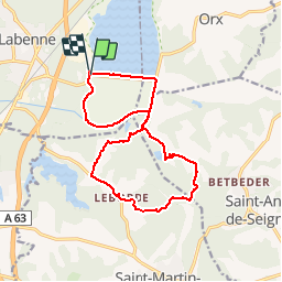
![](/images/other/stat-length.png)
![Trail Walking Labenne - Marais d'Orx et alentours - Photo](https://media.geolcdn.com/t/1900/400/ext.pjpeg?maxdim=2&url=https%3A%2F%2Fservices.sitytrail.com%2FGeolivesWS%2FDownloadMedia.ashx%3FTrailID%3D172398%26Media%3D13745_4.jpg)
Marais d'Orx et alentours
tracegps
User
![Length](/images/other/stat-length.png)
Length
15.5 km
![Max alt](https://static1.geolcdn.com/siteimages/upload/files/1508320355ic_sort_altitude_max_24dp.png)
Max alt
56 m
![Uphill gradient](https://static1.geolcdn.com/siteimages/upload/files/1508320355ic_sort_den_pos_24dp.png)
Uphill gradient
158 m
![Km-Effort](/images/other/stat-length.png)
Km-Effort
17.6 km
![Min alt](https://static1.geolcdn.com/siteimages/upload/files/1508320355ic_sort_altitude_min_24dp.png)
Min alt
-2 m
![Downhill gradient](https://static1.geolcdn.com/siteimages/upload/files/1508320355ic_sort_den_neg_24dp.png)
Downhill gradient
150 m
![Boucle](https://static1.geolcdn.com/siteimages/upload/files/16400158638029165_repeat_loop_refresh_sync_direction_icon.png)
Boucle
Yes
Creation date :
2014-12-10 00:00:00.0
Updated on :
2014-12-10 00:00:00.0
![Walking](https://static1.geolcdn.com/sitytour/trail-icons/101.png)
3h30
Difficulty : Medium
![Scan this QR Code to open this trail in the SityTrail application](https://capi.geolives.com/qq0zvz2zws4bq2lad0pu/sitytour/trails/172398/qr.png?size=200)
FREE GPS app for hiking
About
Trail Walking of 15.5 km to be discovered at New Aquitaine, Landes, Labenne. This trail is proposed by tracegps.
Description
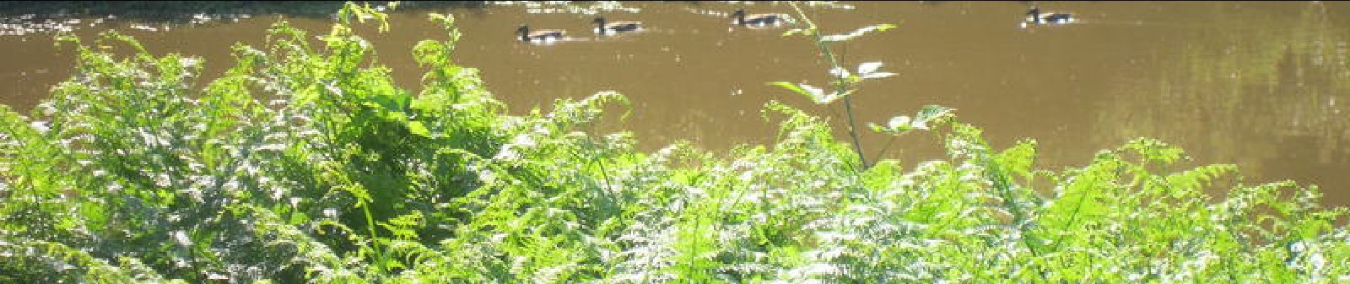
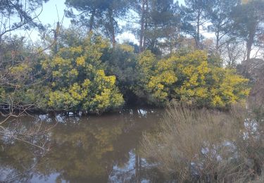
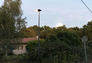
Une randonnée agréable notamment autour du marais (faune principalement). Un détour par les alentours avec un peu de route mais très sympathique. Si vous êtes photos, prenez un petit téléobjectif (70-200).
Positioning
Country:
France
Region :
New Aquitaine
Department/Province :
Landes
Municipality :
Labenne
Location:
Unknown
Start:(Dec)
Start:(UTM)
628507 ; 4827510 (30T) N.
Comments
Trails nearby
![Trail Walking Ondres - Pinède ondres - Photo](https://media.geolcdn.com/t/375/260/ext.jpg?maxdim=2&url=https%3A%2F%2Fstatic1.geolcdn.com%2Fsiteimages%2Fupload%2Ffiles%2F1553511878bg_sport_marche.png)
![Walking Walking](https://static1.geolcdn.com/sitytour/trail-icons/101.png)
Pinède ondres
Walking
Easy
(2)
Ondres,
New Aquitaine,
Landes,
France
![](/images/other/stat-length.png)
9.1 km | 10.1 km-effort
2h 14min
![](https://static1.geolcdn.com/siteimages/upload/files/16400158638029165_repeat_loop_refresh_sync_direction_icon.png)
Yes
![Trail On foot Labenne - Pinède Ondres Jaune - Photo](https://media.geolcdn.com/t/375/260/b4b1e7a3-b617-4f71-bdd9-7457a045d6c9.jpeg&format=jpg&maxdim=2)
![On foot On foot](https://static1.geolcdn.com/sitytour/trail-icons/100.png)
Pinède Ondres Jaune
On foot
Easy
Labenne,
New Aquitaine,
Landes,
France
![](/images/other/stat-length.png)
5.4 km | 6.1 km-effort
1h 22min
![](https://static1.geolcdn.com/siteimages/upload/files/16400158638029165_repeat_loop_refresh_sync_direction_icon.png)
No
![Trail Mountain bike Bénesse-Maremne - Tour benesse - Photo](https://media.geolcdn.com/t/375/260/5c70f6a6-62fc-4eb2-a177-d0b0bc0632ff.jpg&format=jpg&maxdim=2)
![Mountain bike Mountain bike](https://static1.geolcdn.com/sitytour/trail-icons/202.png)
Tour benesse
Mountain bike
Easy
Bénesse-Maremne,
New Aquitaine,
Landes,
France
![](/images/other/stat-length.png)
26 km | 29 km-effort
2h 23min
![](https://static1.geolcdn.com/siteimages/upload/files/16400158638029165_repeat_loop_refresh_sync_direction_icon.png)
Yes
![Trail Walking Ondres - Ondres nord 5.1 - Photo](https://media.geolcdn.com/t/375/260/ext.jpg?maxdim=2&url=https%3A%2F%2Fstatic1.geolcdn.com%2Fsiteimages%2Fupload%2Ffiles%2F1553511878bg_sport_marche.png)
![Walking Walking](https://static1.geolcdn.com/sitytour/trail-icons/101.png)
Ondres nord 5.1
Walking
Very easy
Ondres,
New Aquitaine,
Landes,
France
![](/images/other/stat-length.png)
9.1 km | 9.8 km-effort
3h 10min
![](https://static1.geolcdn.com/siteimages/upload/files/16400158638029165_repeat_loop_refresh_sync_direction_icon.png)
Yes
![Trail Cycle Ondres - Ondres Hossegor - Photo](https://media.geolcdn.com/t/375/260/ext.jpg?maxdim=2&url=https%3A%2F%2Fstatic1.geolcdn.com%2Fsiteimages%2Fupload%2Ffiles%2F1524743154velo.jpg)
![Cycle Cycle](https://static1.geolcdn.com/sitytour/trail-icons/200.png)
Ondres Hossegor
Cycle
Very easy
Ondres,
New Aquitaine,
Landes,
France
![](/images/other/stat-length.png)
38 km | 42 km-effort
3h 21min
![](https://static1.geolcdn.com/siteimages/upload/files/16400158638029165_repeat_loop_refresh_sync_direction_icon.png)
Yes
![Trail Walking Ondres - Ondres 1.2 - Photo](https://media.geolcdn.com/t/375/260/ext.jpg?maxdim=2&url=https%3A%2F%2Fstatic1.geolcdn.com%2Fsiteimages%2Fupload%2Ffiles%2F1553511878bg_sport_marche.png)
![Walking Walking](https://static1.geolcdn.com/sitytour/trail-icons/101.png)
Ondres 1.2
Walking
Very easy
Ondres,
New Aquitaine,
Landes,
France
![](/images/other/stat-length.png)
8.8 km | 9.7 km-effort
2h 30min
![](https://static1.geolcdn.com/siteimages/upload/files/16400158638029165_repeat_loop_refresh_sync_direction_icon.png)
Yes
![Trail Walking Ondres - Ondres Mardi 1 - Photo](https://media.geolcdn.com/t/375/260/ext.jpg?maxdim=2&url=https%3A%2F%2Fstatic1.geolcdn.com%2Fsiteimages%2Fupload%2Ffiles%2F1553511878bg_sport_marche.png)
![Walking Walking](https://static1.geolcdn.com/sitytour/trail-icons/101.png)
Ondres Mardi 1
Walking
Very easy
Ondres,
New Aquitaine,
Landes,
France
![](/images/other/stat-length.png)
7.9 km | 8.7 km-effort
2h 27min
![](https://static1.geolcdn.com/siteimages/upload/files/16400158638029165_repeat_loop_refresh_sync_direction_icon.png)
Yes
![Trail Walking Ondres - Ondres nord 5.1 - Photo](https://media.geolcdn.com/t/375/260/ext.jpg?maxdim=2&url=https%3A%2F%2Fstatic1.geolcdn.com%2Fsiteimages%2Fupload%2Ffiles%2F1553511878bg_sport_marche.png)
![Walking Walking](https://static1.geolcdn.com/sitytour/trail-icons/101.png)
Ondres nord 5.1
Walking
Very easy
Ondres,
New Aquitaine,
Landes,
France
![](/images/other/stat-length.png)
9.1 km | 9.8 km-effort
3h 10min
![](https://static1.geolcdn.com/siteimages/upload/files/16400158638029165_repeat_loop_refresh_sync_direction_icon.png)
Yes
![Trail Walking Saint-André-de-Seignanx - Autour du Marais d'Orx à Labenne - Photo](https://media.geolcdn.com/t/375/260/ext.jpg?maxdim=2&url=https%3A%2F%2Fservices.sitytrail.com%2FGeolivesWS%2FDownloadMedia.ashx%3FTrailID%3D110313%26Media%3D5741_1.jpg)
![Walking Walking](https://static1.geolcdn.com/sitytour/trail-icons/101.png)
Autour du Marais d'Orx à Labenne
Walking
Medium
Saint-André-de-Seignanx,
New Aquitaine,
Landes,
France
![](/images/other/stat-length.png)
5.5 km | 5.7 km-effort
1h 30min
![](https://static1.geolcdn.com/siteimages/upload/files/16400158638029165_repeat_loop_refresh_sync_direction_icon.png)
Yes