![](/images/other/stat-length.png)
![Trail Mountain bike Haulmé - Hazelles - Col du Loup - Bogny sur Meuse - Photo](https://media.geolcdn.com/t/1900/400/ext.pjpeg?maxdim=2&url=https%3A%2F%2Fservices.sitytrail.com%2FGeolivesWS%2FDownloadMedia.ashx%3FTrailID%3D172369%26Media%3D13712_1.jpg)
Hazelles - Col du Loup - Bogny sur Meuse
tracegps
User
![Length](/images/other/stat-length.png)
Length
14.1 km
![Max alt](https://static1.geolcdn.com/siteimages/upload/files/1508320355ic_sort_altitude_max_24dp.png)
Max alt
391 m
![Uphill gradient](https://static1.geolcdn.com/siteimages/upload/files/1508320355ic_sort_den_pos_24dp.png)
Uphill gradient
415 m
![Km-Effort](/images/other/stat-length.png)
Km-Effort
19.6 km
![Min alt](https://static1.geolcdn.com/siteimages/upload/files/1508320355ic_sort_altitude_min_24dp.png)
Min alt
207 m
![Downhill gradient](https://static1.geolcdn.com/siteimages/upload/files/1508320355ic_sort_den_neg_24dp.png)
Downhill gradient
410 m
![Boucle](https://static1.geolcdn.com/siteimages/upload/files/16400158638029165_repeat_loop_refresh_sync_direction_icon.png)
Boucle
Yes
Creation date :
2014-12-10 00:00:00.0
Updated on :
2014-12-10 00:00:00.0
![Mountain bike](https://static1.geolcdn.com/sitytour/trail-icons/202.png)
2h30
Difficulty : Difficult
![Scan this QR Code to open this trail in the SityTrail application](https://capi.geolives.com/qq0zvz2zws4bq2lad0pu/sitytour/trails/172369/qr.png?size=200)
FREE GPS app for hiking
About
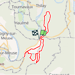
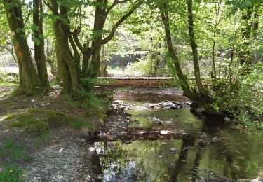
Trail Mountain bike of 14.1 km to be discovered at Grand Est, Ardennes, Haulmé. This trail is proposed by tracegps.
Description
Circuit surtout forestier avec une descente rapide sur une route peu fréquentée. On peut aussi le démarrer au Col du Loup (route entre Nouzonville et Les haut rivières- Thilay: D13).
Positioning
Country:
France
Region :
Grand Est
Department/Province :
Ardennes
Municipality :
Haulmé
Location:
Unknown
Start:(Dec)
Start:(UTM)
629846 ; 5523288 (31U) N.
Comments
Trails nearby
![Trail Walking Haulmé - Thilay - Haulmé - Navaux - Photo](https://media.geolcdn.com/t/375/260/ext.jpg?maxdim=2&url=https%3A%2F%2Fservices.sitytrail.com%2FGeolivesWS%2FDownloadMedia.ashx%3FTrailID%3D214837%26Media%3D15355_6.jpg)
![Walking Walking](https://static1.geolcdn.com/sitytour/trail-icons/101.png)
Thilay - Haulmé - Navaux
Walking
Medium
(3)
Haulmé,
Grand Est,
Ardennes,
France
![](/images/other/stat-length.png)
15.3 km | 21 km-effort
3h 15min
![](https://static1.geolcdn.com/siteimages/upload/files/16400158638029165_repeat_loop_refresh_sync_direction_icon.png)
Yes
![Trail Walking Monthermé - De Monthermé à Bogny sur Meuse par les sentiers de crêtes - Photo](https://media.geolcdn.com/t/375/260/ext.jpg?maxdim=2&url=https%3A%2F%2Fservices.sitytrail.com%2FGeolivesWS%2FDownloadMedia.ashx%3FTrailID%3D109030%26Media%3D2990_6.jpg)
![Walking Walking](https://static1.geolcdn.com/sitytour/trail-icons/101.png)
De Monthermé à Bogny sur Meuse par les sentiers de crêtes
Walking
Difficult
(2)
Monthermé,
Grand Est,
Ardennes,
France
![](/images/other/stat-length.png)
14.6 km | 23 km-effort
5h 0min
![](https://static1.geolcdn.com/siteimages/upload/files/16400158638029165_repeat_loop_refresh_sync_direction_icon.png)
Yes
![Trail Walking Nouzonville - Rando. Nouzonville FFSP - Photo](https://media.geolcdn.com/t/375/260/ext.jpg?maxdim=2&url=https%3A%2F%2Fservices.sitytrail.com%2FGeolivesWS%2FDownloadMedia.ashx%3FTrailID%3D756986%26Media%3D20170521131908.jpg)
![Walking Walking](https://static1.geolcdn.com/sitytour/trail-icons/101.png)
Rando. Nouzonville FFSP
Walking
Medium
(1)
Nouzonville,
Grand Est,
Ardennes,
France
![](/images/other/stat-length.png)
15.9 km | 21 km-effort
3h 55min
![](https://static1.geolcdn.com/siteimages/upload/files/16400158638029165_repeat_loop_refresh_sync_direction_icon.png)
Yes
![Trail Walking Bogny-sur-Meuse - La promenade du Liry et des Quatre Fils Aymon - Photo](https://media.geolcdn.com/t/375/260/ext.jpg?maxdim=2&url=https%3A%2F%2Fstatic1.geolcdn.com%2Fsiteimages%2Fupload%2Ffiles%2F1553511878bg_sport_marche.png)
![Walking Walking](https://static1.geolcdn.com/sitytour/trail-icons/101.png)
La promenade du Liry et des Quatre Fils Aymon
Walking
Medium
(1)
Bogny-sur-Meuse,
Grand Est,
Ardennes,
France
![](/images/other/stat-length.png)
11.4 km | 16.9 km-effort
3h 0min
![](https://static1.geolcdn.com/siteimages/upload/files/16400158638029165_repeat_loop_refresh_sync_direction_icon.png)
Yes
![Trail Walking Les Hautes-Rivières - Hautes Rivières Roches aux Corpias 24,8 - Photo](https://media.geolcdn.com/t/375/260/1bced7d6-1689-4307-97c5-abccba35c800.jpg&format=jpg&maxdim=2)
![Walking Walking](https://static1.geolcdn.com/sitytour/trail-icons/101.png)
Hautes Rivières Roches aux Corpias 24,8
Walking
Difficult
Les Hautes-Rivières,
Grand Est,
Ardennes,
France
![](/images/other/stat-length.png)
25 km | 39 km-effort
8h 34min
![](https://static1.geolcdn.com/siteimages/upload/files/16400158638029165_repeat_loop_refresh_sync_direction_icon.png)
Yes
![Trail On foot Vresse-sur-Semois - Les dolimarts - Photo](https://media.geolcdn.com/t/375/260/ext.jpg?maxdim=2&url=https%3A%2F%2Fpivotmedia.tourismewallonie.be%2FOTH-A0-005T-1NO4%2FOTH-A0-005T-1NO4.jpg)
![On foot On foot](https://static1.geolcdn.com/sitytour/trail-icons/100.png)
Les dolimarts
On foot
Easy
Vresse-sur-Semois,
Wallonia,
Namur,
Belgium
![](/images/other/stat-length.png)
4.2 km | 6.4 km-effort
1h 27min
![](https://static1.geolcdn.com/siteimages/upload/files/16400158638029165_repeat_loop_refresh_sync_direction_icon.png)
Yes
![Trail Other activity Nouzonville - Balade VTT sympa - Photo](https://media.geolcdn.com/t/375/260/ext.jpg?maxdim=2&url=https%3A%2F%2Fstatic1.geolcdn.com%2Fsiteimages%2Fupload%2Ffiles%2F1545311037marcheuse_200dpi.jpg)
![Other activity Other activity](https://static1.geolcdn.com/sitytour/trail-icons/900.png)
Balade VTT sympa
Other activity
Easy
(1)
Nouzonville,
Grand Est,
Ardennes,
France
![](/images/other/stat-length.png)
11.7 km | 13.8 km-effort
1h 18min
![](https://static1.geolcdn.com/siteimages/upload/files/16400158638029165_repeat_loop_refresh_sync_direction_icon.png)
Yes
![Trail Walking Gespunsart - Gespunsart 110324 - Photo](https://media.geolcdn.com/t/375/260/983592c9-ed59-484b-ab3f-739543686869.jpg&format=jpg&maxdim=2)
![Walking Walking](https://static1.geolcdn.com/sitytour/trail-icons/101.png)
Gespunsart 110324
Walking
Medium
Gespunsart,
Grand Est,
Ardennes,
France
![](/images/other/stat-length.png)
19 km | 24 km-effort
4h 17min
![](https://static1.geolcdn.com/siteimages/upload/files/16400158638029165_repeat_loop_refresh_sync_direction_icon.png)
Yes
![Trail Walking Monthermé - La roche 7H Monthermé - Photo](https://media.geolcdn.com/t/375/260/9f5bae53-ca7e-45f9-9b5d-eda45fb0ca79.jpg&format=jpg&maxdim=2)
![Walking Walking](https://static1.geolcdn.com/sitytour/trail-icons/101.png)
La roche 7H Monthermé
Walking
Medium
Monthermé,
Grand Est,
Ardennes,
France
![](/images/other/stat-length.png)
5.9 km | 9 km-effort
2h 24min
![](https://static1.geolcdn.com/siteimages/upload/files/16400158638029165_repeat_loop_refresh_sync_direction_icon.png)
Yes